

<< Our Photo Pages >> Garn Fawr (Pembrokeshire) - Hillfort in Wales in Pembrokeshire
Submitted by pab on Saturday, 01 December 2007 Page Views: 16466
Iron Age and Later PrehistorySite Name: Garn Fawr (Pembrokeshire)Country: Wales County: Pembrokeshire Type: Hillfort
Nearest Town: Fishguard Nearest Village: Trefasser
Map Ref: SM89613882
Latitude: 52.007833N Longitude: 5.066861W
Condition:
| 5 | Perfect |
| 4 | Almost Perfect |
| 3 | Reasonable but with some damage |
| 2 | Ruined but still recognisable as an ancient site |
| 1 | Pretty much destroyed, possibly visible as crop marks |
| 0 | No data. |
| -1 | Completely destroyed |
| 5 | Superb |
| 4 | Good |
| 3 | Ordinary |
| 2 | Not Good |
| 1 | Awful |
| 0 | No data. |
| 5 | Can be driven to, probably with disabled access |
| 4 | Short walk on a footpath |
| 3 | Requiring a bit more of a walk |
| 2 | A long walk |
| 1 | In the middle of nowhere, a nightmare to find |
| 0 | No data. |
| 5 | co-ordinates taken by GPS or official recorded co-ordinates |
| 4 | co-ordinates scaled from a detailed map |
| 3 | co-ordinates scaled from a bad map |
| 2 | co-ordinates of the nearest village |
| 1 | co-ordinates of the nearest town |
| 0 | no data |
Internal Links:
External Links:
I have visited· I would like to visit
jhmcq would like to visit
Humpage visited on 18th Feb 2024 - their rating: Cond: 2 Amb: 5 Access: 4
SandyG visited on 22nd Apr 2021 - their rating: Cond: 3 Amb: 5 Access: 4 Car parking is available nearby. Spectacular views from the fort.
PAB have visited here
Average ratings for this site from all visit loggers: Condition: 2.5 Ambience: 5 Access: 4
 (PID:35434)")
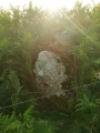
Garn Fawr is magnificently located overlooking Strumble Head and along the Pembrokeshire coast towards St David's Head.
As noted on the RCAHM site, it is 'a hill-top enclosure complex: a central walled area, about 100m by 85m, enclosed with a larger area defined by rock outcrops and further stone walls, about 220m by 140m, having a central roundhouse emplacement.' The smaller Garn Fechan is close by.
As can be seen from these pictures, the hilltop is surprisingly extensive - to really appreciate the setting and the defensive ditches, it is definitely worth looking at RCAMH's aerial pictures via this link.
You may be viewing yesterday's version of this page. To see the most up to date information please register for a free account.
 (PID:112522)")
 (PID:38343)")
 (PID:112520)")
 (PID:203576)")
 (PID:203575)")
 (PID:112521)")
 (PID:112519)")
 (PID:241114)")
 (PID:241113)")
 (PID:241112)")
 (PID:235801)")
 (PID:141813)")
 (PID:141812)")
 (PID:141811)")
 (PID:141810)")
 (PID:112518)")
Do not use the above information on other web sites or publications without permission of the contributor.
Click here to see more info for this site
Nearby sites
Key: Red: member's photo, Blue: 3rd party photo, Yellow: other image, Green: no photo - please go there and take one, Grey: site destroyed
Download sites to:
KML (Google Earth)
GPX (GPS waypoints)
CSV (Garmin/Navman)
CSV (Excel)
To unlock full downloads you need to sign up as a Contributory Member. Otherwise downloads are limited to 50 sites.
Turn off the page maps and other distractions
Nearby sites listing. In the following links * = Image available
170m S 174° Ysgubor Gaer Hillfort (SM89623865)
442m ENE 73° Garn Fechan* Hillfort (SM90043893)
818m WSW 258° Dinas Mawr, Pwllderi, Pencaer* Promontory Fort / Cliff Castle (SM88803869)
1.1km S 172° Castell Poeth Ancient Village or Settlement (SM89723773)
1.2km ENE 70° Garn Gilfach Standing Stone* Standing Stone (Menhir) (SM90803920)
1.3km E 88° Gilfach Farm Standing Stone* Standing Stone (Menhir) (SM90873880)
1.3km E 80° Garn Gilfach.* Rock Cut Tomb (SM909390)
1.9km ENE 63° Trenewydd well* Holy Well or Sacred Spring (SM913396)
2.2km S 189° Castell Bach (Pencaer) Hillfort (SM89193666)
3.1km SE 128° Ffynnondruidion* Chambered Tomb (SM920368)
3.3km S 169° St Nicholas Stones* Early Christian Sculptured Stone (SM901356)
3.3km S 169° St Nicholas Well (N Pembrokeshire)* Holy Well or Sacred Spring (SM901356)
3.4km SE 131° Fynnon Drudion* Standing Stone (Menhir) (SM921365)
3.6km ENE 76° Ffynnon Wnda* Holy Well or Sacred Spring (SM9317939536)
3.7km E 85° Carn Wnda Standing Stone* Standing Stone (Menhir) (SM9327239010)
3.7km ENE 75° St Gwyndaf Stones* Early Christian Sculptured Stone (SM932396)
3.7km E 81° Carn Wnda.* Chambered Tomb (SM93313923)
3.8km SSE 151° Rhos y Clegyrn* Stone Circle (SM9133035456)
4.0km SSE 163° Ffyst Samson* Chambered Tomb (SM90613491)
4.3km SE 137° Penmeiddyn Stone Row / Alignment (SM9241535584)
4.6km SE 125° Manorowen* Standing Stone (Menhir) (SM9324736021)
4.6km E 84° Parc-y-Cromlech* Chambered Tomb (SM94223907)
4.8km SSW 207° Castell Coch (Abercastle)* Promontory Fort / Cliff Castle (SM87243465)
5.2km E 84° Garn Wen 2* Chambered Tomb (SM94803910)
5.2km E 83° Garn Wen 3* Chambered Tomb (SM94803920)
View more nearby sites and additional images


 We would like to know more about this location. Please feel free to add a brief description and any relevant information in your own language.
 Wir möchten mehr über diese Stätte erfahren. Bitte zögern Sie nicht, eine kurze Beschreibung und relevante Informationen in Deutsch hinzuzufügen.
 Nous aimerions en savoir encore un peu sur les lieux. S'il vous plaît n'hesitez pas à ajouter une courte description et tous les renseignements pertinents dans votre propre langue.
 Quisieramos informarnos un poco más de las lugares. No dude en añadir una breve descripción y otros datos relevantes en su propio idioma.