<< Our Photo Pages >> Castell Coch (Abercastle) - Promontory Fort / Cliff Castle in Wales in Pembrokeshire
Submitted by pab on Monday, 09 March 2009 Page Views: 11993
Iron Age and Later PrehistorySite Name: Castell Coch (Abercastle)Country: Wales County: Pembrokeshire Type: Promontory Fort / Cliff Castle
Nearest Town: Fishguard Nearest Village: Abercastle
Map Ref: SM87243465
Latitude: 51.969493N Longitude: 5.098751W
Condition:
| 5 | Perfect |
| 4 | Almost Perfect |
| 3 | Reasonable but with some damage |
| 2 | Ruined but still recognisable as an ancient site |
| 1 | Pretty much destroyed, possibly visible as crop marks |
| 0 | No data. |
| -1 | Completely destroyed |
| 5 | Superb |
| 4 | Good |
| 3 | Ordinary |
| 2 | Not Good |
| 1 | Awful |
| 0 | No data. |
| 5 | Can be driven to, probably with disabled access |
| 4 | Short walk on a footpath |
| 3 | Requiring a bit more of a walk |
| 2 | A long walk |
| 1 | In the middle of nowhere, a nightmare to find |
| 0 | No data. |
| 5 | co-ordinates taken by GPS or official recorded co-ordinates |
| 4 | co-ordinates scaled from a detailed map |
| 3 | co-ordinates scaled from a bad map |
| 2 | co-ordinates of the nearest village |
| 1 | co-ordinates of the nearest town |
| 0 | no data |
Internal Links:
External Links:
I have visited· I would like to visit
PAB has visited here
 (PID:45729)")
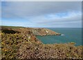
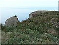
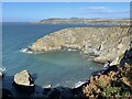
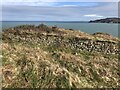
Iron Age Promontory Fort with 2 lines of ditch & rampart across the narrow neck of Pen Morfa headland. Meaning 'red castle' in Welsh, presumably because of the colouring of the rock.
The earth banks of one of the ditches have been supported with stone, but the RCAHMW entry (NPRN 305293) considers the line of banks and entrance to be in their the original positions.
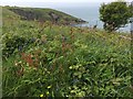
A wonderfully located site, just off the coastal path.
You may be viewing yesterday's version of this page. To see the most up to date information please register for a free account.
Do not use the above information on other web sites or publications without permission of the contributor.
Nearby Images from Geograph Britain and Ireland:
©2022(licence)
©2017(licence)
©2005(licence)
©2023(licence)
©2022(licence)
The above images may not be of the site on this page, they are loaded from Geograph.
Please Submit an Image of this site or go out and take one for us!
Click here to see more info for this site
Nearby sites
Key: Red: member's photo, Blue: 3rd party photo, Yellow: other image, Green: no photo - please go there and take one, Grey: site destroyed
Download sites to:
KML (Google Earth)
GPX (GPS waypoints)
CSV (Garmin/Navman)
CSV (Excel)
To unlock full downloads you need to sign up as a Contributory Member. Otherwise downloads are limited to 50 sites.
Turn off the page maps and other distractions
Nearby sites listing. In the following links * = Image available
2.6km WSW 242° Carreg Samson, Abercastle* Chambered Tomb (SM84843351)
2.8km NE 42° Castell Bach (Pencaer) Hillfort (SM89193666)
2.8km SSE 164° Mathry Church* Early Christian Sculptured Stone (SM879319)
2.9km S 186° Trewalter Llwyd* Chambered Tomb (SM868318)
3.0km S 190° Trewalter Llwyd Standing Stone* Standing Stone (Menhir) (SM86603174)
3.0km ENE 69° St Nicholas Stones* Early Christian Sculptured Stone (SM901356)
3.0km ENE 69° St Nicholas Well (N Pembrokeshire)* Holy Well or Sacred Spring (SM901356)
3.3km WSW 253° Castell Coch, Trefin* Promontory Fort / Cliff Castle (SM83993382)
3.4km E 83° Ffyst Samson* Chambered Tomb (SM90613491)
3.9km NE 36° Castell Poeth Ancient Village or Settlement (SM89723773)
4.2km ENE 76° Rhos y Clegyrn* Stone Circle (SM9133035456)
4.3km NNE 19° Dinas Mawr, Pwllderi, Pencaer* Promontory Fort / Cliff Castle (SM88803869)
4.5km WSW 238° Trefin Modern Stone Circle* Modern Stone Circle etc (SM83333242)
4.6km NNE 28° Ysgubor Gaer Hillfort (SM89623865)
4.8km NNE 27° Garn Fawr (Pembrokeshire)* Hillfort (SM89613882)
4.9km E 99° Castell Hendre-Wen Ancient Village or Settlement (SM92083370)
5.1km NNE 31° Garn Fechan* Hillfort (SM90043893)
5.1km SSE 154° Llain (near Mathry)* Standing Stone (Menhir) (SM8931129938)
5.2km ESE 105° Jordanston* Round Barrow(s) (SM922331)
5.2km ENE 67° Fynnon Drudion* Standing Stone (Menhir) (SM921365)
5.2km ENE 63° Ffynnondruidion* Chambered Tomb (SM920368)
5.2km SW 219° Mesur-y-dorth Stone* Early Christian Sculptured Stone (SM838307)
5.2km ENE 77° Penmeiddyn Stone Row / Alignment (SM9241535584)
5.4km S 171° Blaen-Llyn* Standing Stone (Menhir) (SM87882931)
5.5km NE 39° Gilfach Farm Standing Stone* Standing Stone (Menhir) (SM90873880)
View more nearby sites and additional images


 We would like to know more about this location. Please feel free to add a brief description and any relevant information in your own language.
 Wir möchten mehr über diese Stätte erfahren. Bitte zögern Sie nicht, eine kurze Beschreibung und relevante Informationen in Deutsch hinzuzufügen.
 Nous aimerions en savoir encore un peu sur les lieux. S'il vous plaît n'hesitez pas à ajouter une courte description et tous les renseignements pertinents dans votre propre langue.
 Quisieramos informarnos un poco más de las lugares. No dude en añadir una breve descripción y otros datos relevantes en su propio idioma.