


<< Our Photo Pages >> Trefin Modern Stone Circle - Modern Stone Circle etc in Wales in Pembrokeshire
Submitted by pab on Tuesday, 22 January 2008 Page Views: 14515
Modern SitesSite Name: Trefin Modern Stone CircleCountry: Wales County: Pembrokeshire Type: Modern Stone Circle etc
Nearest Village: Trefin
Map Ref: SM83333242
Latitude: 51.947964N Longitude: 5.154173W
Condition:
| 5 | Perfect |
| 4 | Almost Perfect |
| 3 | Reasonable but with some damage |
| 2 | Ruined but still recognisable as an ancient site |
| 1 | Pretty much destroyed, possibly visible as crop marks |
| 0 | No data. |
| -1 | Completely destroyed |
| 5 | Superb |
| 4 | Good |
| 3 | Ordinary |
| 2 | Not Good |
| 1 | Awful |
| 0 | No data. |
| 5 | Can be driven to, probably with disabled access |
| 4 | Short walk on a footpath |
| 3 | Requiring a bit more of a walk |
| 2 | A long walk |
| 1 | In the middle of nowhere, a nightmare to find |
| 0 | No data. |
| 5 | co-ordinates taken by GPS or official recorded co-ordinates |
| 4 | co-ordinates scaled from a detailed map |
| 3 | co-ordinates scaled from a bad map |
| 2 | co-ordinates of the nearest village |
| 1 | co-ordinates of the nearest town |
| 0 | no data |
Internal Links:
External Links:
I have visited· I would like to visit
TheCaptain visited on 5th Oct 2015 - their rating: Cond: 3 Amb: 4 Access: 5
h_fenton PAB have visited here
")
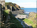
Coming from Careg Sampson at SM 848 335 continue down the lane to Trefin. After passing through the village you will see the circle ahead on high ground overlooking the bay. Parking is best in the small layby on the right as you drive uphill towards the circle. Walk on uphill from here towards a house on the right where there is a stile to the coastal footpath. Go over the stile to reach the site.
You may be viewing yesterday's version of this page. To see the most up to date information please register for a free account.
")
")
Do not use the above information on other web sites or publications without permission of the contributor.
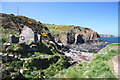
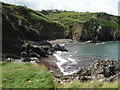
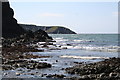
Nearby Images from Geograph Britain and Ireland:
©2010(licence)
©2010(licence)
©2009(licence)
©2007(licence)
©2009(licence)
The above images may not be of the site on this page, they are loaded from Geograph.
Please Submit an Image of this site or go out and take one for us!
Click here to see more info for this site
Nearby sites
Key: Red: member's photo, Blue: 3rd party photo, Yellow: other image, Green: no photo - please go there and take one, Grey: site destroyed
Download sites to:
KML (Google Earth)
GPX (GPS waypoints)
CSV (Garmin/Navman)
CSV (Excel)
To unlock full downloads you need to sign up as a Contributory Member. Otherwise downloads are limited to 50 sites.
Turn off the page maps and other distractions
Nearby sites listing. In the following links * = Image available
1.5km NNE 23° Castell Coch, Trefin* Promontory Fort / Cliff Castle (SM83993382)
1.7km SW 235° Llanrhian Standing Stones* Standing Stones (SM819315)
1.8km SW 232° Llanrhian Church* Early Christian Sculptured Stone (SM819314)
1.8km SSE 162° Mesur-y-dorth Stone* Early Christian Sculptured Stone (SM838307)
1.9km NE 52° Carreg Samson, Abercastle* Chambered Tomb (SM84843351)
3.3km E 99° Trewalter Llwyd Standing Stone* Standing Stone (Menhir) (SM86603174)
3.5km E 98° Trewalter Llwyd* Chambered Tomb (SM868318)
4.1km WSW 254° Abereiddy Promontory Fort* Promontory Fort / Cliff Castle (SM79373150)
4.1km S 188° White House (Treglemais)* Chambered Tomb (SM82582839)
4.3km SSE 149° Treffynnon* Chambered Tomb (SM85362866)
4.5km ENE 58° Castell Coch (Abercastle)* Promontory Fort / Cliff Castle (SM87243465)
4.6km E 94° Mathry Church* Early Christian Sculptured Stone (SM879319)
5.2km SSW 194° Llanhowel Church* Early Christian Sculptured Stone (SM818274)
5.5km ESE 122° Blaen-Llyn* Standing Stone (Menhir) (SM87882931)
5.7km SSW 200° Lecha Dolmen Chambered Tomb (SM81152711)
5.8km ESE 121° Trehale House Standing Stone Standing Stone (Menhir) (SM88152920)
6.1km S 184° Tremaenhir Standing Stones* Standing Stones (SM8268926318)
6.2km ESE 120° Trehale House Standing Stone (Menhir) (SM88542906)
6.2km SSE 155° Llandeloy Holy Well* Holy Well or Sacred Spring (SM857267)
6.3km ESE 122° Trehale Stone* Standing Stone (Menhir) (SM88582883)
6.5km ESE 110° Llain (near Mathry)* Standing Stone (Menhir) (SM8931129938)
6.8km ESE 120° Tre-Howell Burial Chamber or Dolmen (SM891288)
7.0km S 177° Ffynnon Dewi (Solva) Holy Well or Sacred Spring (SM83352544)
7.2km NE 52° Castell Bach (Pencaer) Hillfort (SM89193666)
7.3km ESE 122° St Edren's Cross* Early Christian Sculptured Stone (SM894283)
View more nearby sites and additional images


 We would like to know more about this location. Please feel free to add a brief description and any relevant information in your own language.
 Wir möchten mehr über diese Stätte erfahren. Bitte zögern Sie nicht, eine kurze Beschreibung und relevante Informationen in Deutsch hinzuzufügen.
 Nous aimerions en savoir encore un peu sur les lieux. S'il vous plaît n'hesitez pas à ajouter une courte description et tous les renseignements pertinents dans votre propre langue.
 Quisieramos informarnos un poco más de las lugares. No dude en añadir una breve descripción y otros datos relevantes en su propio idioma.