

<< Our Photo Pages >> Carn Brea Hut circles and Tumulus - Round Barrow(s) in England in Cornwall
Submitted by coldrum on Sunday, 27 July 2008 Page Views: 3704
Neolithic and Bronze AgeSite Name: Carn Brea Hut circles and TumulusCountry: England County: Cornwall Type: Round Barrow(s)
Nearest Village: Sennen Cove
Map Ref: SW3853428372
Latitude: 50.097764N Longitude: 5.657436W
Condition:
| 5 | Perfect |
| 4 | Almost Perfect |
| 3 | Reasonable but with some damage |
| 2 | Ruined but still recognisable as an ancient site |
| 1 | Pretty much destroyed, possibly visible as crop marks |
| 0 | No data. |
| -1 | Completely destroyed |
| 5 | Superb |
| 4 | Good |
| 3 | Ordinary |
| 2 | Not Good |
| 1 | Awful |
| 0 | No data. |
| 5 | Can be driven to, probably with disabled access |
| 4 | Short walk on a footpath |
| 3 | Requiring a bit more of a walk |
| 2 | A long walk |
| 1 | In the middle of nowhere, a nightmare to find |
| 0 | No data. |
| 5 | co-ordinates taken by GPS or official recorded co-ordinates |
| 4 | co-ordinates scaled from a detailed map |
| 3 | co-ordinates scaled from a bad map |
| 2 | co-ordinates of the nearest village |
| 1 | co-ordinates of the nearest town |
| 0 | no data |
Be the first person to rate this site - see the 'Contribute!' box in the right hand menu.
Internal Links:
External Links:
I have visited· I would like to visit
lucasn visited - their rating: Cond: 1 Amb: 4 Access: 4
")
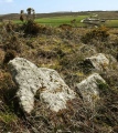
Hut Circles and Tumulus.
Update September 2022: This site is recorded as Historic England List ID 1004244, 'Stone hut circle 390m south east of Little Brea Farm'.
This entry tells us: "The monument includes a stone hut circle, situated on the lower northern slopes of the prominent coastal hill called Carn Brea. The stone hut circle survives as a circular central area of approximately 7m in diameter defined by 1.4m high and 1.7m thick walls with some inner and outer facing orthostats. The hut circle has been incorporated into a field boundary. The hut circle was first noted by Dudley."
You may be viewing yesterday's version of this page. To see the most up to date information please register for a free account.
")
")
")
")
")
")
")
")
")
")
")
")
Do not use the above information on other web sites or publications without permission of the contributor.
Click here to see more info for this site
Nearby sites
Key: Red: member's photo, Blue: 3rd party photo, Yellow: other image, Green: no photo - please go there and take one, Grey: site destroyed
Download sites to:
KML (Google Earth)
GPX (GPS waypoints)
CSV (Garmin/Navman)
CSV (Excel)
To unlock full downloads you need to sign up as a Contributory Member. Otherwise downloads are limited to 50 sites.
Turn off the page maps and other distractions
Nearby sites listing. In the following links * = Image available
167m NE 51° Chapel Carn Brea Stones* Standing Stone (Menhir) (SW38672847)
222m S 181° Chapel Carn Brea Cairns* Barrow Cemetery (SW38522815)
305m SSE 169° Chapel Carn Brea Tomb* Chambered Tomb (SW38582807)
393m S 172° Chapel Carn Brea Long Cairn* Long Barrow (SW38572798)
558m SW 224° Chapel Carn Brea Menhir* Standing Stone (Menhir) (SW3812927987)
667m SSW 193° Kerrow chambered cairn* Chambered Cairn (SW38352773)
689m E 80° Tredinney Cairn* Cairn (SW39222846)
712m S 178° Chycandra Settlement* Ancient Village or Settlement (SW38522766)
1.1km SSE 169° Treave Stonehenge* Modern Stone Circle etc (SW3869227316)
1.2km SE 124° Crows-an-Wra Cross* Ancient Cross (SW39532762)
1.3km ENE 65° Bartine boulder cairn* Cairn (SW39702885)
1.3km NE 41° Bartine Castle* Ancient Village or Settlement (SW39442933)
1.4km NNW 333° Lower Numphra Tumulus* Round Barrow(s) (SW3796529644)
1.4km WSW 241° Tregiffian Vean* Chambered Tomb (SW37252773)
1.5km ENE 66° St Euny's Well Way Ancient Trackway (SW399289)
1.5km SW 233° Trevedra Common Tumuli Barrow Cemetery (SW37292752)
1.5km ENE 67° St Euny's Well (Carn Euny)* Holy Well or Sacred Spring (SW39972890)
1.6km E 94° Brane Entrance Grave* Chambered Tomb (SW40132819)
1.7km ESE 117° Trevorgans Cross* Ancient Cross (SW39982755)
1.7km E 100° Brane Longbarrow* Artificial Mound (SW402280)
1.7km ENE 71° Chapel Euny Well 2* Holy Well or Sacred Spring (SW40212885)
1.8km W 278° Nanquidno Downs Tumulus and Hut Circles* Round Barrow(s) (SW368287)
1.8km ENE 72° Carn Euny Village* Ancient Village or Settlement (SW40242883)
1.8km ENE 71° Carn Euny Fogou* Souterrain (Fogou, Earth House) (SW40242887)
2.0km NNE 30° Leswidden stone* Ancient Cross (SW39653008)
View more nearby sites and additional images


 We would like to know more about this location. Please feel free to add a brief description and any relevant information in your own language.
 Wir möchten mehr über diese Stätte erfahren. Bitte zögern Sie nicht, eine kurze Beschreibung und relevante Informationen in Deutsch hinzuzufügen.
 Nous aimerions en savoir encore un peu sur les lieux. S'il vous plaît n'hesitez pas à ajouter une courte description et tous les renseignements pertinents dans votre propre langue.
 Quisieramos informarnos un poco más de las lugares. No dude en añadir una breve descripción y otros datos relevantes en su propio idioma.