

<< Our Photo Pages >> Gartacharra - Standing Stone (Menhir) in Scotland in Isle of Islay
Submitted by C_Michael_Hogan on Thursday, 15 February 2001 Page Views: 4692
Neolithic and Bronze AgeSite Name: GartacharraCountry: Scotland County: Isle of Islay Type: Standing Stone (Menhir)
Map Ref: NR252613 Landranger Map Number: 60
Latitude: 55.766739N Longitude: 6.382783W
Condition:
| 5 | Perfect |
| 4 | Almost Perfect |
| 3 | Reasonable but with some damage |
| 2 | Ruined but still recognisable as an ancient site |
| 1 | Pretty much destroyed, possibly visible as crop marks |
| 0 | No data. |
| -1 | Completely destroyed |
| 5 | Superb |
| 4 | Good |
| 3 | Ordinary |
| 2 | Not Good |
| 1 | Awful |
| 0 | No data. |
| 5 | Can be driven to, probably with disabled access |
| 4 | Short walk on a footpath |
| 3 | Requiring a bit more of a walk |
| 2 | A long walk |
| 1 | In the middle of nowhere, a nightmare to find |
| 0 | No data. |
| 5 | co-ordinates taken by GPS or official recorded co-ordinates |
| 4 | co-ordinates scaled from a detailed map |
| 3 | co-ordinates scaled from a bad map |
| 2 | co-ordinates of the nearest village |
| 1 | co-ordinates of the nearest town |
| 0 | no data |
Internal Links:
External Links:
I have visited· I would like to visit
hidebasket visited on 13th Aug 2023 - their rating: Cond: -1 Amb: 4 Access: 1 I believe it was knocked down in 2014 from an earthquake and is now completely gone.
Cultoonian visited on 12th Jun 2017 - their rating: Cond: 2 Amb: 4 Access: 3 Fallen down, probably since October 9, 2014. Earthquake Kilchoan. I have photo but can't upload (size 1.2 mb)
C_Michael_Hogan have visited here
Average ratings for this site from all visit loggers: Condition: 0.5 Ambience: 4 Access: 2
")
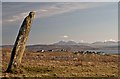
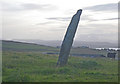
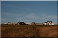
This magnificent and massive prehistoric monument is perched on high ground and is backlit by the sunrise from the southeast. A sliver of Loch Indaal is seen in the distance at image right.
Canmore site no. 37432.
You may be viewing yesterday's version of this page. To see the most up to date information please register for a free account.
Do not use the above information on other web sites or publications without permission of the contributor.
Nearby Images from Geograph Britain and Ireland:
©2013(licence)
©2013(licence)
©2009(licence)
©2013(licence)
©2009(licence)
The above images may not be of the site on this page, they are loaded from Geograph.
Please Submit an Image of this site or go out and take one for us!
Click here to see more info for this site
Nearby sites
Key: Red: member's photo, Blue: 3rd party photo, Yellow: other image, Green: no photo - please go there and take one, Grey: site destroyed
Download sites to:
KML (Google Earth)
GPX (GPS waypoints)
CSV (Garmin/Navman)
CSV (Excel)
To unlock full downloads you need to sign up as a Contributory Member. Otherwise downloads are limited to 50 sites.
![]()
Turn off the page maps and other distractions
Nearby sites listing. In the following links * = Image available
1.4km SW 221° Cnoc Thornasaig Standing Stone (Menhir) (NR242603)
2.9km WSW 249° Cnoc Nan Guaillean Standing Stone* Standing Stone (Menhir) (NR22406042)
3.4km NNE 26° Foreland House Standing Stone (Menhir) (NR269643)
3.7km S 182° Port Charlotte* Chambered Cairn (NR2482957613)
4.6km WSW 241° Gleann Droighneach Standing Stone (Menhir) (NR21055938)
4.6km ENE 60° Uiskentuie* Standing Stone (Menhir) (NR29386336)
4.9km WSW 252° Kilchiaran cup marked stone* Rock Art (NR20436010)
5.5km N 7° Glacan Daraich Ancient Village or Settlement (NR262667)
6.2km ENE 66° Tayandock* Standing Stone (Menhir) (NR31016341)
6.4km SW 216° Giant's Grave (Islay)* Chambered Cairn (NR211564)
6.7km NNW 328° Ballinaby* Stone Row / Alignment (NR2200167206)
7.1km SW 229° Cultoon* Stone Circle (NR19565697)
7.3km SW 220° Lossit Burn Stone Circle (NR202560)
8.9km ENE 67° Knockdon Standing Stone (Menhir) (NR33616424)
10.6km E 86° Gortanilivorrie Standing Stone (Menhir) (NR35816138)
10.7km NNE 14° St Nem's Churchyard (Kilnave)* Ancient Cross (NR285715)
10.7km E 90° Neriby (Bridgend) Standing Stone (Menhir) (NR35956053)
11.7km NE 52° Beinn Cham Standing Stones (NR349679)
11.7km NNE 12° Ardnave Loch* Crannog (NR28317263)
12.7km NE 45° Clach an Tiompain Standing Stone (Menhir) (NR34756977)
12.8km ENE 57° Baile Tarbhach Standing Stone (Menhir) (NR36366762)
14.6km SSE 149° Kintra (Islay) Standing Stone (Menhir) (NR319483)
14.6km SSE 152° Dun A'chail* Stone Fort or Dun (NR31274796)
15.1km ENE 73° Knocklearoch* Standing Stones (NR3989164860)
15.1km SSE 163° Gleann Bun An Easa* Misc. Earthwork (NR2863146542)
View more nearby sites and additional images


 We would like to know more about this location. Please feel free to add a brief description and any relevant information in your own language.
 Wir möchten mehr über diese Stätte erfahren. Bitte zögern Sie nicht, eine kurze Beschreibung und relevante Informationen in Deutsch hinzuzufügen.
 Nous aimerions en savoir encore un peu sur les lieux. S'il vous plaît n'hesitez pas à ajouter une courte description et tous les renseignements pertinents dans votre propre langue.
 Quisieramos informarnos un poco más de las lugares. No dude en añadir una breve descripción y otros datos relevantes en su propio idioma.