

<< Our Photo Pages >> Caratacus Stone - Standing Stone (Menhir) in England in Somerset
Submitted by celia_haddon on Sunday, 18 January 2004 Page Views: 24783
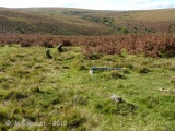
Neolithic and Bronze AgeSite Name: Caratacus StoneCountry: England County: Somerset Type: Standing Stone (Menhir)
Nearest Town: Dulverton Nearest Village: Winsford
Map Ref: SS88973355 Landranger Map Number: 180
Latitude: 51.090481N Longitude: 3.586768W
Condition:
| 5 | Perfect |
| 4 | Almost Perfect |
| 3 | Reasonable but with some damage |
| 2 | Ruined but still recognisable as an ancient site |
| 1 | Pretty much destroyed, possibly visible as crop marks |
| 0 | No data. |
| -1 | Completely destroyed |
| 5 | Superb |
| 4 | Good |
| 3 | Ordinary |
| 2 | Not Good |
| 1 | Awful |
| 0 | No data. |
| 5 | Can be driven to, probably with disabled access |
| 4 | Short walk on a footpath |
| 3 | Requiring a bit more of a walk |
| 2 | A long walk |
| 1 | In the middle of nowhere, a nightmare to find |
| 0 | No data. |
| 5 | co-ordinates taken by GPS or official recorded co-ordinates |
| 4 | co-ordinates scaled from a detailed map |
| 3 | co-ordinates scaled from a bad map |
| 2 | co-ordinates of the nearest village |
| 1 | co-ordinates of the nearest town |
| 0 | no data |
Internal Links:
External Links:
I have visited· I would like to visit
AndyG visited on 17th Aug 2019 - their rating: Cond: 3 Amb: 4 Access: 4 Atmospheric site when visiting in the dark and rain while hiking to an overnight camp.
bishop_pam visited on 23rd Apr 2019 - their rating: Cond: 3 Amb: 3 Access: 4
lucasn visited on 20th Aug 2018 - their rating: Cond: 3 Amb: 4 Access: 5
nicoladidsbury paulcall TheCaptain DaveRenshaw mdensham have visited here
Average ratings for this site from all visit loggers: Condition: 3 Ambience: 3.67 Access: 4.33
")
A shelter was built for it in 1906. Caratacus was the British leader of the rebellion against the Romans in 47-51 AD. The stone was first documented in 1219 as a Forest boundary and called the "Langeston".
Update May 2017: for further information, see Pastscape Monument No. 35777 and The Northern Antiquarian (TNA) page for Caratacus Stone, Winsford, Somerset. The TNA gives directions on how to find this stone, together with a brief archaeology/history and some folklore.
Interestingly, Pastscape records: "The stone is first mentioned in a perambulation of the boundaries of the Royal Forest of Exmoor, dating from 1219, when it was known as the Langeston."
You may be viewing yesterday's version of this page. To see the most up to date information please register for a free account.
")
")
")
")
")
")
")
")
")
")
")
Do not use the above information on other web sites or publications without permission of the contributor.
Click here to see more info for this site
Nearby sites
Key: Red: member's photo, Blue: 3rd party photo, Yellow: other image, Green: no photo - please go there and take one, Grey: site destroyed
Download sites to:
KML (Google Earth)
GPX (GPS waypoints)
CSV (Garmin/Navman)
CSV (Excel)
To unlock full downloads you need to sign up as a Contributory Member. Otherwise downloads are limited to 50 sites.
Turn off the page maps and other distractions
Nearby sites listing. In the following links * = Image available
1.6km WNW 298° Wambarrows* Barrow Cemetery (SS87613431)
2.6km SW 235° Tarr Steps Prehistoric Bridge* Ancient Trackway (SS86773211)
3.8km S 188° Brewer's Castle Hillfort (SS88332977)
4.0km S 185° Mounsey Castle Hillfort (SS88562955)
5.0km W 279° Withypool Hill Barrow* Round Barrow(s) (SS84013445)
5.2km W 277° Withypool Circle* Stone Circle (SS83833431)
5.6km SW 218° West Anstey Barrows* Barrow Cemetery (SS85452918)
5.7km SSE 159° Oldberry Castle Hillfort (SS90932820)
5.8km SW 223° West Anstey Long Stone* Standing Stone (Menhir) (SS84932942)
6.8km ENE 59° Lype Hill Barrows* Barrow Cemetery (SS949370)
7.2km W 277° Green Barrow* Round Barrow(s) (SS81793456)
7.6km N 354° Codsend Moor Multiple Stone Rows / Avenue (SS88364110)
7.8km ENE 73° Cutcombe Barrow* Round Barrow(s) (SS9649635711)
7.8km NNW 335° Hoar Moor (W) Standing Stone (Menhir) (SS85864075)
8.0km NNW 339° Hoar Moor (E)* Standing Stone (Menhir) (SS86214106)
8.1km N 0° Dunkery Beacon* Barrow Cemetery (SS892416)
8.1km NNW 349° Rowbarrow Group* Barrow Cemetery (SS87544154)
8.6km W 260° Twitchen barrows* Barrow Cemetery (SS804323)
8.9km N 359° Sweetworthy settlement* Ancient Village or Settlement (SS890425)
9.0km NNW 337° Wilmersham Common South* Multiple Stone Rows / Avenue (SS85664197)
9.2km NNW 337° Wilmersham Common North* Stone Row / Alignment (SS8561242129)
9.3km N 10° Robin How* Cairn (SS90764273)
9.4km NNW 329° Almsworthy* Stone Circle (SS8430941698)
9.4km N 10° Joaney How Cairn (SS90814279)
10.0km NW 316° Wester Mill Multiple Stone Rows / Avenue (SS822409)
View more nearby sites and additional images


 We would like to know more about this location. Please feel free to add a brief description and any relevant information in your own language.
 Wir möchten mehr über diese Stätte erfahren. Bitte zögern Sie nicht, eine kurze Beschreibung und relevante Informationen in Deutsch hinzuzufügen.
 Nous aimerions en savoir encore un peu sur les lieux. S'il vous plaît n'hesitez pas à ajouter une courte description et tous les renseignements pertinents dans votre propre langue.
 Quisieramos informarnos un poco más de las lugares. No dude en añadir una breve descripción y otros datos relevantes en su propio idioma.