<< Our Photo Pages >> Migneint Mile Slate Slab - Marker Stone in Wales in Conwy
Submitted by TAlanJones on Friday, 27 October 2023 Page Views: 162
Modern SitesSite Name: Migneint Mile Slate SlabCountry: Wales County: Conwy Type: Marker Stone
Nearest Town: Blaneau Ffestiniog Nearest Village: Ysbyty Ifan
Map Ref: SH78984480
Latitude: 52.986827N Longitude: 3.804226W
Condition:
| 5 | Perfect |
| 4 | Almost Perfect |
| 3 | Reasonable but with some damage |
| 2 | Ruined but still recognisable as an ancient site |
| 1 | Pretty much destroyed, possibly visible as crop marks |
| 0 | No data. |
| -1 | Completely destroyed |
| 5 | Superb |
| 4 | Good |
| 3 | Ordinary |
| 2 | Not Good |
| 1 | Awful |
| 0 | No data. |
| 5 | Can be driven to, probably with disabled access |
| 4 | Short walk on a footpath |
| 3 | Requiring a bit more of a walk |
| 2 | A long walk |
| 1 | In the middle of nowhere, a nightmare to find |
| 0 | No data. |
| 5 | co-ordinates taken by GPS or official recorded co-ordinates |
| 4 | co-ordinates scaled from a detailed map |
| 3 | co-ordinates scaled from a bad map |
| 2 | co-ordinates of the nearest village |
| 1 | co-ordinates of the nearest town |
| 0 | no data |
Internal Links:
External Links:
")
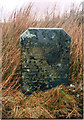
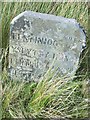
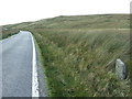
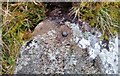
Situated on the northern side of the B4407 narrow road that leads to Ysbyty Ifan through the Migneint Moor, this is a relatively modern slab of slate that indicates the distances to local towns and villages. It stands at 0.75m and is 0.50m wide by 0.08m thick, and leans to the east giving it a quirky appearance
It is inscribed with Ffestiniog 7, Ysbyty Ifan 4 1/2, Pentrefoelas 7 1/2 and Betws y Coed 12.
A nice little (more modern) reminder of the purpose for some of our prehistoric menhirs.
You may be viewing yesterday's version of this page. To see the most up to date information please register for a free account.
")
Do not use the above information on other web sites or publications without permission of the contributor.
Nearby Images from Geograph Britain and Ireland:
©2019(licence)
©2016(licence)
©2016(licence)
©2009(licence)
©2017(licence)
The above images may not be of the site on this page, they are loaded from Geograph.
Please Submit an Image of this site or go out and take one for us!
Click here to see more info for this site
Nearby sites
Key: Red: member's photo, Blue: 3rd party photo, Yellow: other image, Green: no photo - please go there and take one, Grey: site destroyed
Download sites to:
KML (Google Earth)
GPX (GPS waypoints)
CSV (Garmin/Navman)
CSV (Excel)
To unlock full downloads you need to sign up as a Contributory Member. Otherwise downloads are limited to 50 sites.
Turn off the page maps and other distractions
Nearby sites listing. In the following links * = Image available
1.6km NNW 333° Llyn Conwy Island Cairn* Cairn (SH783462)
1.6km NNW 345° Bryniau Duon Cairn near Llyn Conwy* Cairn (SH786464)
1.7km NW 305° Bryn Owen Cairn* Cairn (SH776458)
3.0km WSW 247° Ffynnon Eidda* Holy Well or Sacred Spring (SH762437)
4.2km S 188° Carnedd Iago Stones* Standing Stone (Menhir) (SH7826840651)
4.3km S 188° Carnedd Iago Cairn* Cairn (SH7826340522)
4.4km SE 135° Carnedd Copa Arenig Fach* Cairn (SH8203841599)
4.4km SE 135° Carnedd Y Bachgen* Round Cairn (SH8206041600)
4.4km S 176° Nant yr Olchfa Cairn* Round Cairn (SH7919140367)
4.7km S 177° Nant yr Olchfa Hut Circle* Ancient Village or Settlement (SH79104012)
5.1km WSW 249° Y Garnedd cairn* Cairn (SH742431)
5.2km NE 35° Ysbyty Pont Blaen Eidda Cairn* Cairn (SH82064895)
5.2km SSE 164° Pont Tai Hirion Ancient Bridge* Ancient Trackway (SH803398)
5.2km WSW 236° Llyn Dubach Hut Circle* Ancient Village or Settlement (SH7458642048)
5.2km SSE 164° Afon Taihirion Standing Stone* Standing Stone (Menhir) (SH80303976)
5.3km W 262° Gamallt hut circles* Ancient Village or Settlement (SH737442)
5.5km WSW 236° Pont Yr Afon Hut Circle* Ancient Village or Settlement (SH7434241885)
5.5km WSW 257° Afon Gamallt Hut Circles and Enclosure* Ancient Village or Settlement (SH7359243730)
5.6km WSW 247° Llyn Morwynion Hut Circle ii* Ancient Village or Settlement (SH7373942695)
5.7km WSW 258° Gamallt Iron Age Settlement* Ancient Village or Settlement (SH734438)
5.7km WSW 245° Llyn Morwynion hut circle* Ancient Village or Settlement (SH738425)
5.7km SE 126° Bryn Du Cairn* Cairn (SH8346841315)
5.7km WSW 246° Llyn Morwynion Hut Circle Settlement* Ancient Village or Settlement (SH7372542594)
5.7km WSW 237° Rhaeadr y Cwm Hut Circle* Ancient Village or Settlement (SH7411741772)
5.8km N 359° St Tudclud (Penmachno)* Early Christian Sculptured Stone (SH78995059)
View more nearby sites and additional images


 We would like to know more about this location. Please feel free to add a brief description and any relevant information in your own language.
 Wir möchten mehr über diese Stätte erfahren. Bitte zögern Sie nicht, eine kurze Beschreibung und relevante Informationen in Deutsch hinzuzufügen.
 Nous aimerions en savoir encore un peu sur les lieux. S'il vous plaît n'hesitez pas à ajouter une courte description et tous les renseignements pertinents dans votre propre langue.
 Quisieramos informarnos un poco más de las lugares. No dude en añadir una breve descripción y otros datos relevantes en su propio idioma.