


<< Our Photo Pages >> Bryniau Duon Cairn near Llyn Conwy - Cairn in Wales in Conwy
Submitted by TAlanJones on Saturday, 26 September 2020 Page Views: 398
Neolithic and Bronze AgeSite Name: Bryniau Duon Cairn near Llyn ConwyCountry: Wales County: Conwy Type: Cairn
Nearest Village: Cwm Penmachno
Map Ref: SH786464
Latitude: 53.001116N Longitude: 3.810485W
Condition:
| 5 | Perfect |
| 4 | Almost Perfect |
| 3 | Reasonable but with some damage |
| 2 | Ruined but still recognisable as an ancient site |
| 1 | Pretty much destroyed, possibly visible as crop marks |
| 0 | No data. |
| -1 | Completely destroyed |
| 5 | Superb |
| 4 | Good |
| 3 | Ordinary |
| 2 | Not Good |
| 1 | Awful |
| 0 | No data. |
| 5 | Can be driven to, probably with disabled access |
| 4 | Short walk on a footpath |
| 3 | Requiring a bit more of a walk |
| 2 | A long walk |
| 1 | In the middle of nowhere, a nightmare to find |
| 0 | No data. |
| 5 | co-ordinates taken by GPS or official recorded co-ordinates |
| 4 | co-ordinates scaled from a detailed map |
| 3 | co-ordinates scaled from a bad map |
| 2 | co-ordinates of the nearest village |
| 1 | co-ordinates of the nearest town |
| 0 | no data |
Internal Links:
External Links:
")
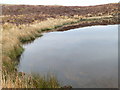
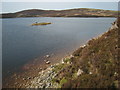
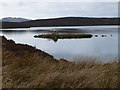
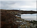
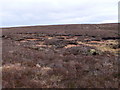
The cairn is situated on high ground to the east of Llyn Conwy. The outcrop beneath the cairn appears made primarily of white quartz. Although the cairn is in a state of poor preservation the remaining rocks that would have covered it seem to be quartz. This suggests that the cairn would have presented as a gleaming white monument on the hillside.
The cairn has a diameter of 7m and there is a 0.2m depression in the centre. It can be reached by following a fisherman's path to the east of the lake. Llyn Conwy can be reached via a trackway from Llyn Cottage just off the B4407 link road from Llan Ffestiniog to Ysbyty Ifan.
You may be viewing yesterday's version of this page. To see the most up to date information please register for a free account.
")
")
")
Do not use the above information on other web sites or publications without permission of the contributor.
Nearby Images from Geograph Britain and Ireland:
©2009(licence)
©2007(licence)
©2009(licence)
©2009(licence)
©2009(licence)
The above images may not be of the site on this page, they are loaded from Geograph.
Please Submit an Image of this site or go out and take one for us!
Click here to see more info for this site
Nearby sites
Key: Red: member's photo, Blue: 3rd party photo, Yellow: other image, Green: no photo - please go there and take one, Grey: site destroyed
Download sites to:
KML (Google Earth)
GPX (GPS waypoints)
CSV (Garmin/Navman)
CSV (Excel)
To unlock full downloads you need to sign up as a Contributory Member. Otherwise downloads are limited to 50 sites.
Turn off the page maps and other distractions
Nearby sites listing. In the following links * = Image available
360m SW 235° Llyn Conwy Island Cairn* Cairn (SH783462)
1.2km WSW 238° Bryn Owen Cairn* Cairn (SH776458)
1.6km SSE 165° Migneint Mile Slate Slab* Marker Stone (SH78984480)
3.6km SW 220° Ffynnon Eidda* Holy Well or Sacred Spring (SH762437)
4.2km N 4° St Tudclud (Penmachno)* Early Christian Sculptured Stone (SH78995059)
4.2km N 5° St Tudclud's Well (Penmachno)* Holy Well or Sacred Spring (SH791506)
4.3km NE 52° Ysbyty Pont Blaen Eidda Cairn* Cairn (SH82064895)
4.4km NNE 19° Y Foel Cairns* Cairn (SH80125056)
5.2km NW 309° Y Ro Wen Cairn* Cairn (SH746498)
5.4km WSW 244° Gamallt hut circles* Ancient Village or Settlement (SH737442)
5.5km SW 232° Y Garnedd cairn* Cairn (SH742431)
5.7km WSW 240° Afon Gamallt Hut Circles and Enclosure* Ancient Village or Settlement (SH7359243730)
5.8km S 182° Carnedd Iago Stones* Standing Stone (Menhir) (SH7826840651)
5.8km WSW 242° Gamallt Iron Age Settlement* Ancient Village or Settlement (SH734438)
5.9km S 182° Carnedd Iago Cairn* Cairn (SH7826340522)
5.9km SE 143° Carnedd Copa Arenig Fach* Cairn (SH8203841599)
5.9km SE 143° Carnedd Y Bachgen* Round Cairn (SH8206041600)
5.9km SW 221° Llyn Dubach Hut Circle* Ancient Village or Settlement (SH7458642048)
6.0km WSW 241° Gamallt Hut Circle east* Ancient Village or Settlement (SH7327843594)
6.1km S 173° Nant yr Olchfa Cairn* Round Cairn (SH7919140367)
6.1km SW 231° Llyn Morwynion Hut Circle ii* Ancient Village or Settlement (SH7373942695)
6.2km WSW 241° Afon Gamallt Hut Circle west* Ancient Village or Settlement (SH7313543535)
6.2km SW 231° Llyn Morwynion Hut Circle Settlement* Ancient Village or Settlement (SH7372542594)
6.2km SW 229° Llyn Morwynion hut circle* Ancient Village or Settlement (SH738425)
6.2km SW 222° Pont Yr Afon Hut Circle* Ancient Village or Settlement (SH7434241885)
View more nearby sites and additional images


 We would like to know more about this location. Please feel free to add a brief description and any relevant information in your own language.
 Wir möchten mehr über diese Stätte erfahren. Bitte zögern Sie nicht, eine kurze Beschreibung und relevante Informationen in Deutsch hinzuzufügen.
 Nous aimerions en savoir encore un peu sur les lieux. S'il vous plaît n'hesitez pas à ajouter une courte description et tous les renseignements pertinents dans votre propre langue.
 Quisieramos informarnos un poco más de las lugares. No dude en añadir una breve descripción y otros datos relevantes en su propio idioma.