<< Our Photo Pages >> Carreg Nant Y Foel - Natural Stone / Erratic / Other Natural Feature in Wales in Conwy
Submitted by TAlanJones on Thursday, 19 October 2023 Page Views: 198
Natural PlacesSite Name: Carreg Nant Y FoelCountry: Wales County: Conwy Type: Natural Stone / Erratic / Other Natural Feature
Nearest Village: Pentrefoelas
Map Ref: SH8690152540
Latitude: 53.058104N Longitude: 3.689004W
Condition:
| 5 | Perfect |
| 4 | Almost Perfect |
| 3 | Reasonable but with some damage |
| 2 | Ruined but still recognisable as an ancient site |
| 1 | Pretty much destroyed, possibly visible as crop marks |
| 0 | No data. |
| -1 | Completely destroyed |
| 5 | Superb |
| 4 | Good |
| 3 | Ordinary |
| 2 | Not Good |
| 1 | Awful |
| 0 | No data. |
| 5 | Can be driven to, probably with disabled access |
| 4 | Short walk on a footpath |
| 3 | Requiring a bit more of a walk |
| 2 | A long walk |
| 1 | In the middle of nowhere, a nightmare to find |
| 0 | No data. |
| 5 | co-ordinates taken by GPS or official recorded co-ordinates |
| 4 | co-ordinates scaled from a detailed map |
| 3 | co-ordinates scaled from a bad map |
| 2 | co-ordinates of the nearest village |
| 1 | co-ordinates of the nearest town |
| 0 | no data |
Internal Links:
External Links:
")
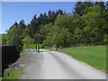
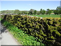
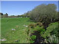
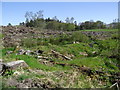
Situated to the west of Nant y Foel stream and close to a field boundary wall this stone provides an interesting feature as walkers pass by along the Hiraethog Trail. The trail leads northwards from Pentrefoelas village towards Llyn Alwen.
From the footpath the stone appears to be cubic in shape with seams of quartz running through it. It's dimensions are 1.40m N to S by 1.20m E to W, and 0.80M in height. It lies close to the stream that forms a natural boundary in the field.
An interesting looking stone with purpose, if any, unknown.
You may be viewing yesterday's version of this page. To see the most up to date information please register for a free account.
")
")
")
Do not use the above information on other web sites or publications without permission of the contributor.
Nearby Images from Geograph Britain and Ireland:
©2017(licence)
©2017(licence)
©2017(licence)
©2022(licence)
©2017(licence)
The above images may not be of the site on this page, they are loaded from Geograph.
Please Submit an Image of this site or go out and take one for us!
Click here to see more info for this site
Nearby sites
Key: Red: member's photo, Blue: 3rd party photo, Yellow: other image, Green: no photo - please go there and take one, Grey: site destroyed
Download sites to:
KML (Google Earth)
GPX (GPS waypoints)
CSV (Garmin/Navman)
CSV (Excel)
To unlock full downloads you need to sign up as a Contributory Member. Otherwise downloads are limited to 50 sites.
Turn off the page maps and other distractions
Nearby sites listing. In the following links * = Image available
935m SSE 161° Lon Mynydd Hiraethog* Ancient Trackway (SH8719051650)
1.2km NE 44° Hafod Y Garreg Earthworks and Cairns* Barrow Cemetery (SH8773053360)
1.3km NE 44° Hafod y Garreg Row* Stone Row / Alignment (SH87815345)
1.3km NE 48° Hafod Y Garreg Cist* Cist (SH8790053400)
1.3km NE 44° Ffridd Can Awen Cists* Cist (SH8786053480)
1.4km NE 36° Ffridd Can Awen Cairn* Cairn (SH8774053620)
1.4km NE 46° Hafod Y Carreg Cairn Field* Barrow Cemetery (SH8793053470)
1.7km NE 37° Cefnen Wen Cairn Field* Barrow Cemetery (SH8796053890)
2.0km NE 53° Hafod y Dre* Stone Row / Alignment (SH88535371)
2.1km NE 36° Cefnen Wen Cairn and Cist* Cairn (SH8817054170)
2.1km NE 38° Cefnen Wen Cairn East* Cairn (SH8824054160)
2.3km NNW 336° Maes Merddyn Ring Cairn 1* Ring Cairn (SH8600054660)
2.3km NNW 334° Maes Merddyn Ring Cairn 2* Ring Cairn (SH85925463)
2.7km NE 36° Bryniau Duon Cairn on Hiraethog Trail* Cairn (SH8855054670)
2.9km NE 34° Moel Rhiwlug Recumbent* Natural Stone / Erratic / Other Natural Feature (SH8855954892)
3.0km NNE 27° Moel Rhiwlug Cairn 2* Cairn (SH88295515)
3.0km ESE 124° Carreg Nanw* Modern Stone Circle etc (SH8940550794)
3.2km NNE 27° Moel Rhiwlug Cairn 1* Cairn (SH88445538)
3.6km NE 34° Pen Yr Orsedd Ring Cairn* Ring Cairn (SH8901055460)
3.7km ENE 65° Bwlch y Garnedd Hut Circle* Ancient Village or Settlement (SH90305401)
3.9km ENE 64° Bwlch y Garnedd Menhir Standing Stone (Menhir) (SH9045254194)
3.9km ENE 64° Lon Bwlch y Garnedd standing stones* Standing Stones (SH9046154197)
4.1km NNW 329° Bryn-Cyplau Cairn Circle East Ring Cairn (SH8489756103)
4.1km NNW 329° Bryn-Cyplau Cairn Circle West Ring Cairn (SH8486156102)
4.3km ENE 61° Bwlch y Garnedd Cairn 3 Cairn (SH90695450)
View more nearby sites and additional images


 We would like to know more about this location. Please feel free to add a brief description and any relevant information in your own language.
 Wir möchten mehr über diese Stätte erfahren. Bitte zögern Sie nicht, eine kurze Beschreibung und relevante Informationen in Deutsch hinzuzufügen.
 Nous aimerions en savoir encore un peu sur les lieux. S'il vous plaît n'hesitez pas à ajouter une courte description et tous les renseignements pertinents dans votre propre langue.
 Quisieramos informarnos un poco más de las lugares. No dude en añadir una breve descripción y otros datos relevantes en su propio idioma.