<< Our Photo Pages >> Edderton Stone Circle - Cairn in Scotland in Highlands
Submitted by brianlavelle on Saturday, 02 September 2023 Page Views: 113
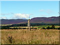
Neolithic and Bronze AgeSite Name: Edderton Stone Circle Alternative Name: Carriblair Stone CircleCountry: Scotland County: Highlands Type: Cairn
Nearest Town: Edderton Nearest Village: Carriblair
Map Ref: NH70908511
Latitude: 57.836834N Longitude: 4.176045W
Condition:
| 5 | Perfect |
| 4 | Almost Perfect |
| 3 | Reasonable but with some damage |
| 2 | Ruined but still recognisable as an ancient site |
| 1 | Pretty much destroyed, possibly visible as crop marks |
| 0 | No data. |
| -1 | Completely destroyed |
| 5 | Superb |
| 4 | Good |
| 3 | Ordinary |
| 2 | Not Good |
| 1 | Awful |
| 0 | No data. |
| 5 | Can be driven to, probably with disabled access |
| 4 | Short walk on a footpath |
| 3 | Requiring a bit more of a walk |
| 2 | A long walk |
| 1 | In the middle of nowhere, a nightmare to find |
| 0 | No data. |
| 5 | co-ordinates taken by GPS or official recorded co-ordinates |
| 4 | co-ordinates scaled from a detailed map |
| 3 | co-ordinates scaled from a bad map |
| 2 | co-ordinates of the nearest village |
| 1 | co-ordinates of the nearest town |
| 0 | no data |
Internal Links:
External Links:
I have visited· I would like to visit
brianlavelle visited on 10th May 2023 - their rating: Cond: 2 Amb: 3 Access: 5
")
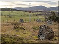
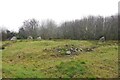
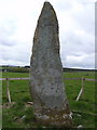
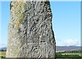
A fairly dilapidated stone circle with four or five stones remaining, of a reported ten. There are also the remains of a possible cist near the centre of the circle. The circle is about 80 metres southwest of the Clach Biorach (Edderton 1) Pictish stone and easily accessible from the road, although it is a little overgrown. The site was originally scheduled in 1970 and re-scheduled by Historic Environment Scotland in 2016.
You may be viewing yesterday's version of this page. To see the most up to date information please register for a free account.
")
")
Do not use the above information on other web sites or publications without permission of the contributor.
Nearby Images from Geograph Britain and Ireland:
©2019(licence)
©2020(licence)
©2010(licence)
©2008(licence)
©2008(licence)
The above images may not be of the site on this page, they are loaded from Geograph.
Please Submit an Image of this site or go out and take one for us!
Click here to see more info for this site
Nearby sites
Key: Red: member's photo, Blue: 3rd party photo, Yellow: other image, Green: no photo - please go there and take one, Grey: site destroyed
Download sites to:
KML (Google Earth)
GPX (GPS waypoints)
CSV (Garmin/Navman)
CSV (Excel)
To unlock full downloads you need to sign up as a Contributory Member. Otherwise downloads are limited to 50 sites.
Turn off the page maps and other distractions
Nearby sites listing. In the following links * = Image available
89m WSW 242° Edderton 1* Class I Pictish Symbol Stone (NH70828507)
1.4km SE 130° Edderton 2 Class III Pictish Cross Slab (NH7190984203)
2.5km SE 130° Red Burn Chambered Cairn (NH72788341)
2.6km WNW 284° Lower Lechanich South Chambered Tomb (NH684858)
2.6km WNW 286° Lower Lechanich North Chambered Tomb (NH684859)
2.8km W 275° Leachonich Broch or Nuraghe (NH68128546)
3.0km ESE 123° Edderton Hill Cairn (NH734834)
3.5km NW 309° Ardvannie* Chambered Cairn (NH68238740)
4.4km N 8° Clach a' Charra* Standing Stone (Menhir) (NH7164789493)
5.5km WNW 286° Dun Alascaig Broch or Nuraghe (NH65698682)
5.7km SSE 158° Morangie Forest Chambered Cairn (NH729798)
6.4km NW 323° Cairn, Fairy Glen, Bailenacile Cairn (NH672904)
6.4km NW 323° Allt nan Eun Chambered Cairn Chambered Cairn (NH672904)
7.1km NW 326° Achaidh Chambered Cairn* Chambered Cairn (NH671911)
7.6km NW 320° Kyleoag Chambered Cairn Chambered Cairn (NH662911)
7.7km ESE 111° Ardjachie Farm* Rock Art (NH7802882137)
8.0km SSE 150° Wester Lamington* Cairn (NH747780)
8.3km WNW 297° St Demhan's Cross* Early Christian Sculptured Stone (NH636892)
8.5km SSE 167° Scotsburn Wood East Chambered Tomb (NH726768)
8.5km S 170° Scotsburn Wood West Chambered Tomb (NH721767)
8.9km S 174° Scotsburn House Chambered Cairn Chambered Cairn (NH71537618)
9.0km S 174° Scotsburn House Dun* Stone Fort or Dun (NH71487616)
9.8km S 184° Kinrive West Chambered Cairn (NH69937538)
10.0km S 185° King's Head Cairn Chambered Cairn (NH69777513)
10.6km NW 306° Loch Migdale Henge (NH62429160)
View more nearby sites and additional images


 We would like to know more about this location. Please feel free to add a brief description and any relevant information in your own language.
 Wir möchten mehr über diese Stätte erfahren. Bitte zögern Sie nicht, eine kurze Beschreibung und relevante Informationen in Deutsch hinzuzufügen.
 Nous aimerions en savoir encore un peu sur les lieux. S'il vous plaît n'hesitez pas à ajouter une courte description et tous les renseignements pertinents dans votre propre langue.
 Quisieramos informarnos un poco más de las lugares. No dude en añadir una breve descripción y otros datos relevantes en su propio idioma.