<< Our Photo Pages >> St Demhan's Cross - Early Christian Sculptured Stone in Scotland in Sutherland
Submitted by Sunny100 on Sunday, 20 November 2011 Page Views: 5904
Early Medieval (Dark Age)Site Name: St Demhan's Cross Alternative Name: St Demhan's Stone, The Creich StoneCountry: Scotland County: Sutherland Type: Early Christian Sculptured Stone
Nearest Town: Dornoch Nearest Village: Bonar Bridge
Map Ref: NH636892
Latitude: 57.871374N Longitude: 4.301227W
Condition:
| 5 | Perfect |
| 4 | Almost Perfect |
| 3 | Reasonable but with some damage |
| 2 | Ruined but still recognisable as an ancient site |
| 1 | Pretty much destroyed, possibly visible as crop marks |
| 0 | No data. |
| -1 | Completely destroyed |
| 5 | Superb |
| 4 | Good |
| 3 | Ordinary |
| 2 | Not Good |
| 1 | Awful |
| 0 | No data. |
| 5 | Can be driven to, probably with disabled access |
| 4 | Short walk on a footpath |
| 3 | Requiring a bit more of a walk |
| 2 | A long walk |
| 1 | In the middle of nowhere, a nightmare to find |
| 0 | No data. |
| 5 | co-ordinates taken by GPS or official recorded co-ordinates |
| 4 | co-ordinates scaled from a detailed map |
| 3 | co-ordinates scaled from a bad map |
| 2 | co-ordinates of the nearest village |
| 1 | co-ordinates of the nearest town |
| 0 | no data |
Internal Links:
External Links:
")
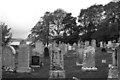
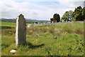
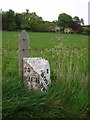
Close to the graveyard wall (east side) is an unhewn Bronze-Age standing stone that is almost 7 foot tall and 2 foot wide. Though the stone is prehistoric it was used by early Christians during the 6th-10th century CE when an elaborate Latin-style cross was carved onto its flat north face; sadly the cross is quite faint and worn now. At the base there is a large rounded stone which may be a support for the cross-slab.
The stone is thought to mark the grave of St Demhan, Demenac or Devenic an unknown Celtic saint. Some historians consider the cross to be similar to those seen on Pictish stones - so this monument should, perhaps, be thought of as being in that category.
You may be viewing yesterday's version of this page. To see the most up to date information please register for a free account.
")
")
Do not use the above information on other web sites or publications without permission of the contributor.
Nearby Images from Geograph Britain and Ireland:
©2010(licence)
©2011(licence)
©2019(licence)
©2022(licence)
©2014(licence)
The above images may not be of the site on this page, they are loaded from Geograph.
Please Submit an Image of this site or go out and take one for us!
Click here to see more info for this site
Nearby sites
Key: Red: member's photo, Blue: 3rd party photo, Yellow: other image, Green: no photo - please go there and take one, Grey: site destroyed
Download sites to:
KML (Google Earth)
GPX (GPS waypoints)
CSV (Garmin/Navman)
CSV (Excel)
To unlock full downloads you need to sign up as a Contributory Member. Otherwise downloads are limited to 50 sites.
Turn off the page maps and other distractions
Nearby sites listing. In the following links * = Image available
2.7km NNW 332° Loch Migdale Henge (NH62429160)
3.2km SE 137° Dun Alascaig Broch or Nuraghe (NH65698682)
3.2km NE 52° Kyleoag Chambered Cairn Chambered Cairn (NH662911)
3.8km ENE 70° Cairn, Fairy Glen, Bailenacile Cairn (NH672904)
3.8km ENE 70° Allt nan Eun Chambered Cairn Chambered Cairn (NH672904)
4.0km ENE 60° Achaidh Chambered Cairn* Chambered Cairn (NH671911)
4.7km W 278° Carn Deasgan Broch or Nuraghe (NH5990)
5.0km ESE 109° Ardvannie* Chambered Cairn (NH68238740)
5.8km ESE 123° Lower Lechanich North Chambered Tomb (NH684859)
5.9km SE 128° Leachonich Broch or Nuraghe (NH68128546)
5.9km ESE 123° Lower Lechanich South Chambered Tomb (NH684858)
8.0km E 86° Clach a' Charra* Standing Stone (Menhir) (NH7164789493)
8.3km ESE 118° Edderton 1* Class I Pictish Symbol Stone (NH70828507)
8.3km ESE 117° Edderton Stone Circle* Cairn (NH70908511)
8.8km W 278° Gruinards Broch or Nuraghe (NH549908)
9.6km NW 320° Invershin Farm* Standing Stone (Menhir) (NH5760796742)
9.7km ESE 119° Edderton 2 Class III Pictish Cross Slab (NH7190984203)
10.8km ESE 120° Red Burn Chambered Cairn (NH72788341)
11.4km ESE 119° Edderton Hill Cairn (NH734834)
12.0km NNE 33° Strath Tollidh* Broch or Nuraghe (NH705990)
12.2km W 265° St John the Baptist's Well (Fodderty)* Holy Well or Sacred Spring (NH514885)
12.7km NNW 334° Auchinduich* Stone Circle (NC58450084)
13.2km SE 133° Morangie Forest Chambered Cairn (NH729798)
13.3km S 179° Baldoon Chambered Cairn (NH63317591)
13.5km NW 316° Linsidemore* Stone Circle (NH54509918)
View more nearby sites and additional images


 We would like to know more about this location. Please feel free to add a brief description and any relevant information in your own language.
 Wir möchten mehr über diese Stätte erfahren. Bitte zögern Sie nicht, eine kurze Beschreibung und relevante Informationen in Deutsch hinzuzufügen.
 Nous aimerions en savoir encore un peu sur les lieux. S'il vous plaît n'hesitez pas à ajouter une courte description et tous les renseignements pertinents dans votre propre langue.
 Quisieramos informarnos un poco más de las lugares. No dude en añadir una breve descripción y otros datos relevantes en su propio idioma.