<< Our Photo Pages >> Callanish 9 - Standing Stones in Scotland in Isle of Lewis
Submitted by Anonymous on Sunday, 11 February 2001 Page Views: 6650
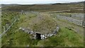
Neolithic and Bronze AgeSite Name: Callanish 9 Alternative Name: Druim nam Bidearan, Callanish IXCountry: Scotland County: Isle of Lewis Type: Standing Stones
Nearest Town: Stornoway Nearest Village: Callanish
Map Ref: NB233297 Landranger Map Number: 8
Latitude: 58.169139N Longitude: 6.707266W
Condition:
| 5 | Perfect |
| 4 | Almost Perfect |
| 3 | Reasonable but with some damage |
| 2 | Ruined but still recognisable as an ancient site |
| 1 | Pretty much destroyed, possibly visible as crop marks |
| 0 | No data. |
| -1 | Completely destroyed |
| 5 | Superb |
| 4 | Good |
| 3 | Ordinary |
| 2 | Not Good |
| 1 | Awful |
| 0 | No data. |
| 5 | Can be driven to, probably with disabled access |
| 4 | Short walk on a footpath |
| 3 | Requiring a bit more of a walk |
| 2 | A long walk |
| 1 | In the middle of nowhere, a nightmare to find |
| 0 | No data. |
| 5 | co-ordinates taken by GPS or official recorded co-ordinates |
| 4 | co-ordinates scaled from a detailed map |
| 3 | co-ordinates scaled from a bad map |
| 2 | co-ordinates of the nearest village |
| 1 | co-ordinates of the nearest town |
| 0 | no data |
Internal Links:
External Links:
I have visited· I would like to visit
tom_bullock has visited here
")
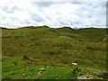
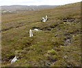
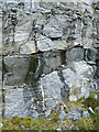
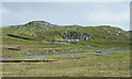
Very close to the cairn, which is indicated in OS Pathfinder Map 69, 2 long stones lie.
You may be viewing yesterday's version of this page. To see the most up to date information please register for a free account.
")
")
")
Do not use the above information on other web sites or publications without permission of the contributor.
Nearby Images from Geograph Britain and Ireland:
©2009(licence)
©2018(licence)
©2011(licence)
©2011(licence)
©2021(licence)
The above images may not be of the site on this page, they are loaded from Geograph.
Please Submit an Image of this site or go out and take one for us!
Click here to see more info for this site
Nearby sites
Key: Red: member's photo, Blue: 3rd party photo, Yellow: other image, Green: no photo - please go there and take one, Grey: site destroyed
Download sites to:
KML (Google Earth)
GPX (GPS waypoints)
CSV (Garmin/Navman)
CSV (Excel)
To unlock full downloads you need to sign up as a Contributory Member. Otherwise downloads are limited to 50 sites.
![]()
![]()
Turn off the page maps and other distractions
Nearby sites listing. In the following links * = Image available
238m NNE 29° Callanish 5* Stone Row / Alignment (NB23432990)
509m NNW 345° Callanish 7* Ancient Mine, Quarry or other Industry (NB232302)
775m NNW 332° Callanish 4* Stone Circle (NB2298830412)
1.2km ESE 109° Callanish 18* Standing Stone (Menhir) (NB24402923)
1.5km ENE 61° Callanish 6* Standing Stones (NB24653034)
2.3km N 6° Callanish 17* Stone Circle (NB237320)
2.4km NNW 341° Cnoc Fillibhir Mhor* Stone Row / Alignment (NB22683207)
3.0km NNW 335° Loch Roag Timber Circle (NB222325)
3.1km NNW 336° Callanish 2* Stone Circle (NB2221432614)
3.1km NNW 341° Callanish 3* Stone Circle (NB2251532710)
3.2km NNW 347° Callanish 14* Standing Stone (Menhir) (NB228329)
3.7km NNW 332° Callanish 19* Stone Circle (NB218331)
3.9km NW 325° Callanish* Stone Circle (NB2129833013)
3.9km NW 325° Callanish I* Stone Circle (NB2128633009)
3.9km N 351° Callanish 10* Stone Circle (NB22973362)
4.5km NNW 330° Callanish 16* Standing Stone (Menhir) (NB213338)
4.7km NNW 334° Callanish 13* Standing Stones (NB215341)
5.2km NNW 339° Olcote Kerbed Cairn* Cairn (NB2179634733)
5.5km NNW 338° Callanish 12* Standing Stone (Menhir) (NB2155634967)
6.1km NNW 346° Callanish 11* Standing Stone (Menhir) (NB22233569)
6.2km NNW 335° Cnoc a Phrionnsa* Chambered Cairn (NB211355)
7.4km NW 307° Callanish 15* Standing Stone (Menhir) (NB177345)
8.0km WNW 301° Dun Barraglom Broch or Nuraghe (NB16773435)
8.0km WNW 301° Barraglom Cup-Marked Rock Rock Art (NB167343)
8.0km WNW 298° Callanish 8A* Standing Stone (Menhir) (NB165340)
View more nearby sites and additional images


 We would like to know more about this location. Please feel free to add a brief description and any relevant information in your own language.
 Wir möchten mehr über diese Stätte erfahren. Bitte zögern Sie nicht, eine kurze Beschreibung und relevante Informationen in Deutsch hinzuzufügen.
 Nous aimerions en savoir encore un peu sur les lieux. S'il vous plaît n'hesitez pas à ajouter une courte description et tous les renseignements pertinents dans votre propre langue.
 Quisieramos informarnos un poco más de las lugares. No dude en añadir una breve descripción y otros datos relevantes en su propio idioma.