


<< Our Photo Pages >> Clash-an-dam - Stone Row / Alignment in Scotland in Caithness
Submitted by Anne T on Thursday, 05 May 2016 Page Views: 1100
Neolithic and Bronze AgeSite Name: Clash-an-damCountry: Scotland County: Caithness Type: Stone Row / Alignment
Nearest Town: Wick Nearest Village: Whaligoe
Map Ref: ND3125640434
Latitude: 58.346993N Longitude: 3.176084W
Condition:
| 5 | Perfect |
| 4 | Almost Perfect |
| 3 | Reasonable but with some damage |
| 2 | Ruined but still recognisable as an ancient site |
| 1 | Pretty much destroyed, possibly visible as crop marks |
| 0 | No data. |
| -1 | Completely destroyed |
| 5 | Superb |
| 4 | Good |
| 3 | Ordinary |
| 2 | Not Good |
| 1 | Awful |
| 0 | No data. |
| 5 | Can be driven to, probably with disabled access |
| 4 | Short walk on a footpath |
| 3 | Requiring a bit more of a walk |
| 2 | A long walk |
| 1 | In the middle of nowhere, a nightmare to find |
| 0 | No data. |
| 5 | co-ordinates taken by GPS or official recorded co-ordinates |
| 4 | co-ordinates scaled from a detailed map |
| 3 | co-ordinates scaled from a bad map |
| 2 | co-ordinates of the nearest village |
| 1 | co-ordinates of the nearest town |
| 0 | no data |
Be the first person to rate this site - see the 'Contribute!' box in the right hand menu.
Internal Links:
External Links:
I have visited· I would like to visit
SandyG visited on 3rd Sep 2016 - their rating: Cond: 2 Amb: 4 Access: 3 This is a tricky one to get to. Car parking is available at ND 31885 40851. Follow the old railway line south to ND 31592 40498. From here walk uphill across uneven open moorland. Alternatively access may be available from the nearby Groat’s Loch, South stone row.
")
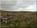
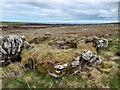
Recorded as Canmore Site ID 271100 in the parish of Wick, there are 17 small to medium sized stones making up six to seven rows, with no more than three stones in any one row.
The record adds: "fourteen of the stones stand on or close to a modern post-and-wire fence, and the remaining three are situated in poorly drained ground some 30m to the WSW. None of the stones is more than 0.55m in height, most are much shorter, and the distance between the rows varies from about 2.5m to 3m."
Update October 2019: This row is featured on the Stone Rows of Great Britain website - see their entry for Clash-an-Dam, which tells us this row has a length of 35 metres, is at an orientation of 67.5 degrees, and "forms part of a cluster including at least 9 stone rows near Loch Watenan and has definable visual links with the sea, nearby cairns, chambered cairns and stone rows".
The SRoGB entry includes a description, photographs and access information, plus links to other online resources for more information. They also have a separate page to discuss and illustrate the Sea Views at Clash-an-Dam, showing how the alignment is "positioned to provide evolving views of the sea".
SandyG, creator of the Stone Rows of Great Britain website, asks visitors to note that "this is a tricky one to get to". See his visit report or access information section on his webpage for this alignment for more information.
You may be viewing yesterday's version of this page. To see the most up to date information please register for a free account.
")
")
Do not use the above information on other web sites or publications without permission of the contributor.
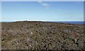
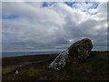
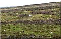
Nearby Images from Geograph Britain and Ireland:
©2018(licence)
©2022(licence)
©2018(licence)
©2022(licence)
©2022(licence)
The above images may not be of the site on this page, they are loaded from Geograph.
Please Submit an Image of this site or go out and take one for us!
Click here to see more info for this site
Nearby sites
Key: Red: member's photo, Blue: 3rd party photo, Yellow: other image, Green: no photo - please go there and take one, Grey: site destroyed
Download sites to:
KML (Google Earth)
GPX (GPS waypoints)
CSV (Garmin/Navman)
CSV (Excel)
To unlock full downloads you need to sign up as a Contributory Member. Otherwise downloads are limited to 50 sites.
![]()
Turn off the page maps and other distractions
Nearby sites listing. In the following links * = Image available
322m NW 313° Groat’s Loch, South* Stone Row / Alignment (ND3102340658)
397m NNW 336° Broughwin III* Stone Row / Alignment (ND3110040800)
459m NNW 334° Cairn east of Cairn Hanach* Cairn (ND31064085)
488m NNW 327° Cairn Hanach* Chambered Cairn (ND31004085)
530m N 359° Broughwin II* Multiple Stone Rows / Avenue (ND3125440965)
571m N 355° Broughwin IV* Multiple Stone Rows / Avenue (ND3121541004)
689m N 5° Cairn o'Get* Chambered Cairn (ND31334112)
789m N 3° Broughwin I* Multiple Stone Rows / Avenue (ND3130741222)
799m NNE 17° Watenan Farm* Multiple Stone Rows / Avenue (ND3150941193)
806m NE 36° Loch Watenan* Multiple Stone Rows / Avenue (ND31744108)
847m NNE 32° Watenan South Broch* Broch or Nuraghe (ND3171641147)
865m N 7° Garrywhin Multiple Stone Rows* Multiple Stone Rows / Avenue (ND3138241291)
942m N 359° Garrywhin Fort* Hillfort (ND3125341377)
972m SSW 193° Bruan* Broch or Nuraghe (ND31023949)
1.2km NNE 27° Watenan North Broch Broch or Nuraghe (ND3180441456)
1.2km NW 310° Warehouse Hill Broch or Nuraghe (ND3034841227)
1.2km NE 42° Marquel Stone Row / Alignment (ND32114134)
1.6km NE 47° Ulbster School Broch or Nuraghe (ND3243141497)
1.7km NNE 15° Watenan East* Stone Row / Alignment (ND31724204)
1.7km N 1° Watenan West* Stone Row / Alignment (ND31324218)
1.8km NNW 337° Warehouse South* Chambered Cairn (ND3057342081)
1.8km NNW 335° Warehouse West* Cairn (ND3050742107)
1.9km NNW 334° Warehouse Standing Stone* Standing Stone (Menhir) (ND3046242147)
1.9km NE 48° Heatherquoy Broch or Nuraghe (ND3271341714)
2.0km NNW 339° Warehouse North* Chambered Cairn (ND3056742276)
View more nearby sites and additional images


 We would like to know more about this location. Please feel free to add a brief description and any relevant information in your own language.
 Wir möchten mehr über diese Stätte erfahren. Bitte zögern Sie nicht, eine kurze Beschreibung und relevante Informationen in Deutsch hinzuzufügen.
 Nous aimerions en savoir encore un peu sur les lieux. S'il vous plaît n'hesitez pas à ajouter une courte description et tous les renseignements pertinents dans votre propre langue.
 Quisieramos informarnos un poco más de las lugares. No dude en añadir una breve descripción y otros datos relevantes en su propio idioma.