


<< Our Photo Pages >> Eithbed Tombs - Chambered Tomb in Wales in Pembrokeshire
Submitted by vicky on Monday, 30 September 2002 Page Views: 5496
Neolithic and Bronze AgeSite Name: Eithbed Tombs Alternative Name: Eithbedd TombsCountry: Wales County: Pembrokeshire Type: Chambered Tomb
Nearest Town: Newport Nearest Village: Rosebush
Map Ref: SN07982864 Landranger Map Number: 145
Latitude: 51.923078N Longitude: 4.793871W
Condition:
| 5 | Perfect |
| 4 | Almost Perfect |
| 3 | Reasonable but with some damage |
| 2 | Ruined but still recognisable as an ancient site |
| 1 | Pretty much destroyed, possibly visible as crop marks |
| 0 | No data. |
| -1 | Completely destroyed |
| 5 | Superb |
| 4 | Good |
| 3 | Ordinary |
| 2 | Not Good |
| 1 | Awful |
| 0 | No data. |
| 5 | Can be driven to, probably with disabled access |
| 4 | Short walk on a footpath |
| 3 | Requiring a bit more of a walk |
| 2 | A long walk |
| 1 | In the middle of nowhere, a nightmare to find |
| 0 | No data. |
| 5 | co-ordinates taken by GPS or official recorded co-ordinates |
| 4 | co-ordinates scaled from a detailed map |
| 3 | co-ordinates scaled from a bad map |
| 2 | co-ordinates of the nearest village |
| 1 | co-ordinates of the nearest town |
| 0 | no data |
Internal Links:
External Links:
")
In 1911 Bushell wrote:
'There were at Eithbed until very recently three circles; and probably three cromlechs also were associated with them. They are now no more.' The largest circle, described as being no less than 150ft in diameter was marked on early editions of the OS Map, but had been removed by 1908. Although according to Bushell it was still traceable on the ground. Suggestions have been made that this was perhaps a henge (Figgis, Prehistorc Preseli 2001).
Two other circles had also once stood a little to the south-west, one of which was destroyed in 1905 and the other of which was broken up in 1909 `to build an ugly house which stands close by'. Also within the complex were three cromlechs arranged in a line to the north-west of the smaller circles.
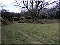
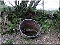
On a recent visit we were able to locate the remains of the cromlechs which now form part of a field boundary, providing a shelter for the local cows (see picture in the eGallery). All traces of the circles had disappeared but there were several stones along one side of the neighbouring field which looked as if they may have come from one of them.
You may be viewing yesterday's version of this page. To see the most up to date information please register for a free account.
")
")
Do not use the above information on other web sites or publications without permission of the contributor.
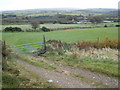
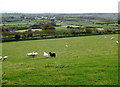
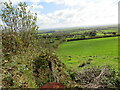
Nearby Images from Geograph Britain and Ireland:
©2008(licence)
©2008(licence)
©2022(licence)
©2008(licence)
©2008(licence)
The above images may not be of the site on this page, they are loaded from Geograph.
Please Submit an Image of this site or go out and take one for us!
Click here to see more info for this site
Nearby sites
Key: Red: member's photo, Blue: 3rd party photo, Yellow: other image, Green: no photo - please go there and take one, Grey: site destroyed
Download sites to:
KML (Google Earth)
GPX (GPS waypoints)
CSV (Garmin/Navman)
CSV (Excel)
To unlock full downloads you need to sign up as a Contributory Member. Otherwise downloads are limited to 50 sites.
Turn off the page maps and other distractions
Nearby sites listing. In the following links * = Image available
99m NE 43° Eithbed Enclosure* Ancient Village or Settlement (SN08052871)
657m NNE 15° Eithbed Cairn* Ring Cairn (SN08172927)
681m SSE 163° Maenclochog Standing Stones* Standing Stones (SN08152798)
985m ENE 66° Eithbed Stone Standing Stone (Menhir) (SN089290)
1.1km SE 135° Galchen Fach* Standing Stones (SN08752780)
1.3km ENE 63° Eithbed Circles* Stone Circle (SN092292)
1.4km SSE 169° Maenclochog Church Early Christian Sculptured Stone (SN082273)
1.4km W 263° Budloy Stone* Standing Stone (Menhir) (SN06562853)
1.5km NE 44° Mynydd Crwn Standing Stone Standing Stone (Menhir) (SN091297)
1.6km SSW 194° St Mary's Well (Maenclochog)* Holy Well or Sacred Spring (SN0752527055)
1.8km S 177° Cilmoor Stone* Standing Stone (Menhir) (SN08002688)
1.8km NNE 18° Cnwc Barrow 2 Round Barrow(s) (SN086303)
2.0km NNE 22° Cnwc Barrow 1 Round Barrow(s) (SN088305)
2.1km W 263° Dyffryn Syfynwy* Stone Circle (SN05922845)
2.2km SE 130° Temple Druid Henge (SN096272)
2.2km SE 130° Temple Druid Standing Stone* Standing Stone (Menhir) (SN0965427147)
2.3km SE 130° Prysg Farm Stone* Standing Stone (Menhir) (SN0968327102)
2.3km ESE 123° Temple Druid Modern Stone Circle etc (SN099273)
2.4km WNW 286° Bernard's Well Mountain* Ancient Village or Settlement (SN057294)
2.4km SSE 147° Castell Forlan Ancient Village or Settlement (SN09202657)
2.6km N 356° Mynydd Du* Cairn (SN079312)
2.7km WSW 254° St Brynach's Well* Holy Well or Sacred Spring (SN054280)
2.7km SE 126° St Teilo's Well* Holy Well or Sacred Spring (SN101270)
2.7km NW 315° Banc Du Causewayed Enclosure* Causewayed Enclosure (SN06123065)
2.9km NNE 27° Foel Cwmcerwyn* Cairn (SN094312)
View more nearby sites and additional images


 We would like to know more about this location. Please feel free to add a brief description and any relevant information in your own language.
 Wir möchten mehr über diese Stätte erfahren. Bitte zögern Sie nicht, eine kurze Beschreibung und relevante Informationen in Deutsch hinzuzufügen.
 Nous aimerions en savoir encore un peu sur les lieux. S'il vous plaît n'hesitez pas à ajouter une courte description et tous les renseignements pertinents dans votre propre langue.
 Quisieramos informarnos un poco más de las lugares. No dude en añadir una breve descripción y otros datos relevantes en su propio idioma.