

<< Our Photo Pages >> Ballymarlagh - Court Tomb in Ireland (Northern) in Co. Antrim
Submitted by SolarMegalith on Tuesday, 18 December 2012 Page Views: 3025
Neolithic and Bronze AgeSite Name: BallymarlaghCountry: Ireland (Northern) County: Co. Antrim Type: Court Tomb
Nearest Town: Belfast Nearest Village: Ballymena
Map Ref: D14040175
Latitude: 54.850518N Longitude: 6.225274W
Condition:
| 5 | Perfect |
| 4 | Almost Perfect |
| 3 | Reasonable but with some damage |
| 2 | Ruined but still recognisable as an ancient site |
| 1 | Pretty much destroyed, possibly visible as crop marks |
| 0 | No data. |
| -1 | Completely destroyed |
| 5 | Superb |
| 4 | Good |
| 3 | Ordinary |
| 2 | Not Good |
| 1 | Awful |
| 0 | No data. |
| 5 | Can be driven to, probably with disabled access |
| 4 | Short walk on a footpath |
| 3 | Requiring a bit more of a walk |
| 2 | A long walk |
| 1 | In the middle of nowhere, a nightmare to find |
| 0 | No data. |
| 5 | co-ordinates taken by GPS or official recorded co-ordinates |
| 4 | co-ordinates scaled from a detailed map |
| 3 | co-ordinates scaled from a bad map |
| 2 | co-ordinates of the nearest village |
| 1 | co-ordinates of the nearest town |
| 0 | no data |
Be the first person to rate this site - see the 'Contribute!' box in the right hand menu.
Internal Links:
External Links:
")
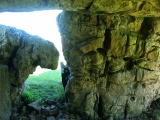
A Neolithic court tomb.
You may be viewing yesterday's version of this page. To see the most up to date information please register for a free account.
")
")
")
Do not use the above information on other web sites or publications without permission of the contributor.
Nearby Images from Geograph Britain and Ireland:
©2010(licence)
©2010(licence)
©2010(licence)
©2010(licence)
©2007(licence)
The above images may not be of the site on this page, they are loaded from Geograph.
Please Submit an Image of this site or go out and take one for us!
Click here to see more info for this site
Nearby sites
Click here to view sites on an interactive map of the areaKey: Red: member's photo, Blue: 3rd party photo, Yellow: other image, Green: no photo - please go there and take one, Grey: site destroyed
Download sites to:
KML (Google Earth)
GPX (GPS waypoints)
CSV (Garmin/Navman)
CSV (Excel)
To unlock full downloads you need to sign up as a Contributory Member. Otherwise downloads are limited to 50 sites.
Turn off the page maps and other distractions
Nearby sites listing. In the following links * = Image available
1.8km WSW 255° Ballymena Ring Fort Hillfort
3.9km NNE 29° St. Patrick's Stone* Standing Stone (Menhir) (NW310621)
6.1km SSE 155° Carncome Standing Stone* Standing Stone (Menhir)
11.4km SSE 146° Browndod Court Tomb* Court Tomb
13.1km SSE 150° Tobergill Stone Circle (J20839051)
13.3km N 357° Lisnamanny Stone Circle Stone Circle (D130150)
13.3km NE 54° Tamybuck Wedge Tomb* Wedge Tomb (NW401660)
13.7km N 359° Two Standing Stones in Lisnamanny* Standing Stones (D1345015470)
14.1km N 357° Lisnamanny Standing Stone* Standing Stone (Menhir) (D1305015860)
14.2km NE 41° Ticloy* Portal Tomb (D232127)
14.6km SSE 151° Donegore Hill Causewayed Enclosure
14.7km N 357° Standing Stone (Skerry West)* Standing Stone (Menhir) (NW289735)
14.7km NE 53° Antynanum* Court Tomb (D25561094)
15.0km SE 139° Doagh* Holed Stone (J2416590683)
15.1km W 275° Slievenagh* Stone Circle (C9895602726)
15.3km SSE 157° Donegore Moat* Artificial Mound
15.8km N 353° Standing Stone (Scotchomerbane)* Standing Stone (Menhir) (NW278746)
17.4km SE 142° Moyadam* Standing Stone (Menhir) (J2510388312)
19.3km ESE 105° Carndoo* Court Tomb (J32849731)
19.3km ENE 73° Dunteige* Wedge Tomb (D32350798)
19.5km ENE 65° Deer Park Farms* Standing Stone (Menhir) (NW470661)
19.7km ENE 64° Goakstown* Wedge Tomb
19.8km E 84° Larne Standing Stone* Standing Stone (Menhir)
19.9km ENE 75° Linford Barrows* Artificial Mound (D33230723)
19.9km ENE 75° Linford Round Cairn Round Cairn
View more nearby sites and additional images


 We would like to know more about this location. Please feel free to add a brief description and any relevant information in your own language.
 Wir möchten mehr über diese Stätte erfahren. Bitte zögern Sie nicht, eine kurze Beschreibung und relevante Informationen in Deutsch hinzuzufügen.
 Nous aimerions en savoir encore un peu sur les lieux. S'il vous plaît n'hesitez pas à ajouter une courte description et tous les renseignements pertinents dans votre propre langue.
 Quisieramos informarnos un poco más de las lugares. No dude en añadir una breve descripción y otros datos relevantes en su propio idioma.