

<< Our Photo Pages >> St Martin's Church (Laugharne) - Ancient Cross in Wales in Carmarthenshire
Submitted by Sunny100 on Monday, 03 October 2011 Page Views: 7157
Early Medieval (Dark Age)Site Name: St Martin's Church (Laugharne) Alternative Name: The Laugharne CrossCountry: Wales County: Carmarthenshire Type: Ancient Cross
Nearest Town: Carmarthen Nearest Village: Laugharne
Map Ref: SN302110
Latitude: 51.771849N Longitude: 4.462412W
Condition:
| 5 | Perfect |
| 4 | Almost Perfect |
| 3 | Reasonable but with some damage |
| 2 | Ruined but still recognisable as an ancient site |
| 1 | Pretty much destroyed, possibly visible as crop marks |
| 0 | No data. |
| -1 | Completely destroyed |
| 5 | Superb |
| 4 | Good |
| 3 | Ordinary |
| 2 | Not Good |
| 1 | Awful |
| 0 | No data. |
| 5 | Can be driven to, probably with disabled access |
| 4 | Short walk on a footpath |
| 3 | Requiring a bit more of a walk |
| 2 | A long walk |
| 1 | In the middle of nowhere, a nightmare to find |
| 0 | No data. |
| 5 | co-ordinates taken by GPS or official recorded co-ordinates |
| 4 | co-ordinates scaled from a detailed map |
| 3 | co-ordinates scaled from a bad map |
| 2 | co-ordinates of the nearest village |
| 1 | co-ordinates of the nearest town |
| 0 | no data |
Internal Links:
External Links:
I have visited· I would like to visit
PAB has visited here
 (PID:138001)")
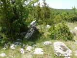
Inside St Martins church beside the A4066 in Laugharne there is a curious shaped cross-slab dating from the so-called Dark Ages, probably the 9th-10th century.
The slab stone is built into the east wall of the south transept and has an unusual Celtic design carved onto it; though some historians claim the designwork is of Viking origins. The cross is oddly shaped, reminiscent of a human body perhaps. There is thick ropework, in the form of looped interlacing, running up from the bottom to the cross-head, while close to the edges ordinary, less thick knotwork. The large round-shaped cross-head has a Latin-style cross in the centre with a small boss in the middle of that and oval looped links between the arms.
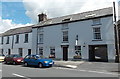
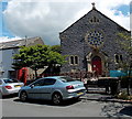
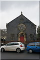
The church of St Martin dates from the 14th century when it was built by the Lord of the Manor of Laugharne Sir Guido de Brian. He also built the church St Margaret in Eglwys Cummin some 5 miles to the west. If you have five minutes to spare check out the famous grave of Dylan Thomas (d 1953) in the churchyard which is marked by a white cross.
You may be viewing yesterday's version of this page. To see the most up to date information please register for a free account.
 (PID:99668)")
 (PID:82669)")
Do not use the above information on other web sites or publications without permission of the contributor.
Nearby Images from Geograph Britain and Ireland:
©2014(licence)
©2014(licence)
©2015(licence)
©2011(licence)
©2015(licence)
The above images may not be of the site on this page, they are loaded from Geograph.
Please Submit an Image of this site or go out and take one for us!
Click here to see more info for this site
Nearby sites
Key: Red: member's photo, Blue: 3rd party photo, Yellow: other image, Green: no photo - please go there and take one, Grey: site destroyed
Download sites to:
KML (Google Earth)
GPX (GPS waypoints)
CSV (Garmin/Navman)
CSV (Excel)
To unlock full downloads you need to sign up as a Contributory Member. Otherwise downloads are limited to 50 sites.
Turn off the page maps and other distractions
Nearby sites listing. In the following links * = Image available
1.9km W 274° Llandawke Inscribed Stone* Early Christian Sculptured Stone (SN2827111214)
2.5km SW 221° Coygan Cave Cave or Rock Shelter (SN28480913)
3.2km NNE 16° Gors Llangynog* Standing Stones (SN312140)
3.2km NNE 21° Meini Llwydion, Llangynog* Standing Stones (SN3145513969)
3.2km W 261° Holy Stones Llansadurnan Sculptured Stone
3.9km N 7° Pont Ddu* Stone Row / Alignment (SN30791484)
4.3km E 91° Fron Ucha* Chambered Tomb (SN3455510744)
4.5km ESE 102° St Anthony's Well (Llansteffan)* Holy Well or Sacred Spring (SN34600993)
4.8km ENE 66° Maen Melyn, Llanybri* Standing Stone (Menhir) (SN34711279)
4.9km E 85° Waun y Felin Burial Chamber or Dolmen (SN351113)
5.0km E 97° Llansteffan Castle* Hillfort (SN352102)
5.5km E 89° Maen Llwyd, St Ishmail* Standing Stone (Menhir) (SN3569610910)
5.6km NNW 329° Eithin Fach Mound* Round Barrow(s) (SN27521589)
5.9km NW 306° Cross Stones, Llanddowror* Early Christian Sculptured Stone (SN25531458)
5.9km WNW 286° Castell Pen-Y-Coed Hillfort (SN24531278)
6.0km NW 308° Llanddowror Standing stone* Standing Stone (Menhir) (SN25621487)
6.3km NNE 33° Twlc y Filiast* Chambered Tomb (SN33811618)
6.3km WNW 298° Vaynor Farm Henge* Henge (SN24701417)
6.5km NNE 29° Bryn Cywyn* Ancient Village or Settlement (SN33551660)
7.7km WSW 244° Pendine Bone Cave* Cave or Rock Shelter (SN23200782)
7.9km E 87° Is-Coed* Standing Stone (Menhir) (SN381112)
8.1km WSW 243° Gilman Point fort* Promontory Fort / Cliff Castle (SN228076)
8.5km E 79° Maen Llwyd (Carmarthenshire)* Standing Stone (Menhir) (SN386123)
8.7km ENE 58° Meini Llwydion* Chambered Tomb (SN37721534)
8.8km WSW 245° Morfa Bychan* Chambered Cairn (SN22130749)
View more nearby sites and additional images


 We would like to know more about this location. Please feel free to add a brief description and any relevant information in your own language.
 Wir möchten mehr über diese Stätte erfahren. Bitte zögern Sie nicht, eine kurze Beschreibung und relevante Informationen in Deutsch hinzuzufügen.
 Nous aimerions en savoir encore un peu sur les lieux. S'il vous plaît n'hesitez pas à ajouter une courte description et tous les renseignements pertinents dans votre propre langue.
 Quisieramos informarnos un poco más de las lugares. No dude en añadir una breve descripción y otros datos relevantes en su propio idioma.