

<< Text Pages >> Holm of Papa Westray Central - Chambered Cairn in Scotland in Orkney
Submitted by pab on Thursday, 23 June 2016 Page Views: 8587
Neolithic and Bronze AgeSite Name: Holm of Papa Westray CentralCountry: Scotland County: Orkney Type: Chambered Cairn
Nearest Town: Pierowall, Westray Nearest Village: Papa Westray
Map Ref: HY50705185
Latitude: 59.350084N Longitude: 2.868666W
Condition:
| 5 | Perfect |
| 4 | Almost Perfect |
| 3 | Reasonable but with some damage |
| 2 | Ruined but still recognisable as an ancient site |
| 1 | Pretty much destroyed, possibly visible as crop marks |
| 0 | No data. |
| -1 | Completely destroyed |
| 5 | Superb |
| 4 | Good |
| 3 | Ordinary |
| 2 | Not Good |
| 1 | Awful |
| 0 | No data. |
| 5 | Can be driven to, probably with disabled access |
| 4 | Short walk on a footpath |
| 3 | Requiring a bit more of a walk |
| 2 | A long walk |
| 1 | In the middle of nowhere, a nightmare to find |
| 0 | No data. |
| 5 | co-ordinates taken by GPS or official recorded co-ordinates |
| 4 | co-ordinates scaled from a detailed map |
| 3 | co-ordinates scaled from a bad map |
| 2 | co-ordinates of the nearest village |
| 1 | co-ordinates of the nearest town |
| 0 | no data |
Internal Links:
External Links:
I have visited· I would like to visit
DrewParsons coin whese001 would like to visit
PAB jeffrep have visited here
Note: More information can be found on Canmore ID 3244.
You may be viewing yesterday's version of this page. To see the most up to date information please register for a free account.
Do not use the above information on other web sites or publications without permission of the contributor.
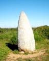
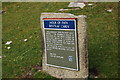
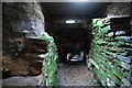
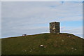
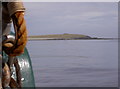
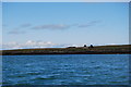
Nearby Images from Geograph Britain and Ireland:
©2009(licence)
©2009(licence)
©2009(licence)
©2007(licence)
©2009(licence)
The above images may not be of the site on this page, they are loaded from Geograph.
Please Submit an Image of this site or go out and take one for us!
Click here to see more info for this site
Nearby sites
Key: Red: member's photo, Blue: 3rd party photo, Yellow: other image, Green: no photo - please go there and take one, Grey: site destroyed
Download sites to:
KML (Google Earth)
GPX (GPS waypoints)
CSV (Garmin/Navman)
CSV (Excel)
To unlock full downloads you need to sign up as a Contributory Member. Otherwise downloads are limited to 50 sites.
Turn off the page maps and other distractions
Nearby sites listing. In the following links * = Image available
210m E 95° Holm of Papa Westray South* Chambered Cairn (HY50915183)
502m NNW 328° Holm of Papa Westray North* Chambered Cairn (HY50445228)
1.4km SW 226° St Tredwell's Chapel Stone Row / Alignment (HY497509)
2.1km WNW 294° St Boniface's Church Hog Back Stone* Early Christian Sculptured Stone (HY48825270)
2.1km WNW 294° Munkerhoose* Ancient Village or Settlement (HY48785274)
2.4km W 268° Knap of Howar* Ancient Village or Settlement (HY483518)
5.0km WSW 253° Vere Point (Westray) Chambered Cairn (HY45845046)
6.0km SW 223° Tofts Ness (Sanday) Cairn (HY4654547449)
6.8km SSW 192° East Surrigarth (Westray) Chambered Cairn (HY49214520)
7.3km WSW 247° Pierowall Quarry* Chambered Cairn (HY43894905)
7.8km WSW 242° Westray Heritage Centre* Museum (HY43724825)
8.3km WSW 251° Links of Noltland* Ancient Village or Settlement (HY42804930)
8.8km WSW 238° Curquoy, Westray Cairn (HY431473)
8.9km WSW 251° The Lum Head (Westray) Chambered Cairn (HY4221649107)
9.2km WSW 237° Knucker Hill (Westray) Chambered Cairn (HY4287547013)
10.4km SW 224° Fitty Hill (Westray) Chambered Cairn (HY43324451)
10.9km SW 221° Powdykes (Westray) Chambered Cairn (HY4343543627)
12.0km SSW 213° Berst Ness Ancient Village or Settlement (HY441418)
13.3km SSE 159° Linkertaing* Chambered Cairn (HY55393937)
14.0km S 171° Faray Chambered Cairn (HY52743797)
14.2km SSE 156° Carrick House* Chambered Cairn (HY56363880)
14.7km SSE 158° Vinquoy* Chambered Cairn (HY56013809)
15.0km SSE 151° Calf of Eday (Long) Chambered Cairn (HY57863861)
15.1km SSE 151° Calf of Eday, North West Round Cairn (HY57883858)
15.1km SSE 151° Calf of Eday Southeast Chambered Cairn (HY57923852)
View more nearby sites and additional images


 We would like to know more about this location. Please feel free to add a brief description and any relevant information in your own language.
 Wir möchten mehr über diese Stätte erfahren. Bitte zögern Sie nicht, eine kurze Beschreibung und relevante Informationen in Deutsch hinzuzufügen.
 Nous aimerions en savoir encore un peu sur les lieux. S'il vous plaît n'hesitez pas à ajouter une courte description et tous les renseignements pertinents dans votre propre langue.
 Quisieramos informarnos un poco más de las lugares. No dude en añadir una breve descripción y otros datos relevantes en su propio idioma.