

<< Our Photo Pages >> Flint workshop west of wadi Racham - Ancient Mine, Quarry or other Industry in Israel
Submitted by motist on Thursday, 13 May 2010 Page Views: 3078
Multi-periodSite Name: Flint workshop west of wadi RachamCountry: Israel Type: Ancient Mine, Quarry or other Industry
Nearest Town: Eilat Nearest Village: Beer Ora
Latitude: 29.693659N Longitude: 34.929332E
Condition:
| 5 | Perfect |
| 4 | Almost Perfect |
| 3 | Reasonable but with some damage |
| 2 | Ruined but still recognisable as an ancient site |
| 1 | Pretty much destroyed, possibly visible as crop marks |
| 0 | No data. |
| -1 | Completely destroyed |
| 5 | Superb |
| 4 | Good |
| 3 | Ordinary |
| 2 | Not Good |
| 1 | Awful |
| 0 | No data. |
| 5 | Can be driven to, probably with disabled access |
| 4 | Short walk on a footpath |
| 3 | Requiring a bit more of a walk |
| 2 | A long walk |
| 1 | In the middle of nowhere, a nightmare to find |
| 0 | No data. |
| 5 | co-ordinates taken by GPS or official recorded co-ordinates |
| 4 | co-ordinates scaled from a detailed map |
| 3 | co-ordinates scaled from a bad map |
| 2 | co-ordinates of the nearest village |
| 1 | co-ordinates of the nearest town |
| 0 | no data |
Internal Links:
External Links:
")
Thousands of flint shards, blades, arrowheads, awls, bores, hand stones, cores, and microliths were found. Also dolomite and sandstone bowls made by chiseling, and one shell from the Red Sea. Chunks of sandstone used to sharpen the utensils and more.
Going by the assortment of the flints the span of activity at the site spans more then 2500 years.
You may be viewing yesterday's version of this page. To see the most up to date information please register for a free account.
")
")
")
")
")
Do not use the above information on other web sites or publications without permission of the contributor.
Click here to see more info for this site
Nearby sites
Click here to view sites on an interactive map of the areaKey: Red: member's photo, Blue: 3rd party photo, Yellow: other image, Green: no photo - please go there and take one, Grey: site destroyed
Download sites to:
KML (Google Earth)
GPX (GPS waypoints)
CSV (Garmin/Navman)
CSV (Excel)
To unlock full downloads you need to sign up as a Contributory Member. Otherwise downloads are limited to 50 sites.
Turn off the page maps and other distractions
Nearby sites listing. In the following links * = Image available
247m E 96° S' of wadi 'Eteq* Ancient Temple
1.4km WNW 288° Wadi 'Eteq Villas* Ancient Temple
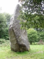
1.7km S 174° Wadi Racham Matsebah* Standing Stones
2.7km WSW 243° North of Wadi Shani Masseboth* Standing Stones
3.6km S 191° Upper Wadi Racham Camp* Standing Stones
3.7km WNW 285° E' Se'ipim valley* Ancient Village or Settlement
3.7km N 9° S' of wadi Gadna'a* Ancient Temple
4.0km ENE 65° E' of wadi Racham * Ancient Temple
4.2km W 269° SE' Se'ipim valley* Ancient Village or Settlement
4.3km ESE 110° Nitsots hill open air sanctuary* Ancient Temple
4.8km ENE 65° Beer-Ora N* Ancient Temple
5.2km WNW 300° North Se'ipim Valley Predator Trap* Ancient Mine, Quarry or other Industry
5.3km WNW 297° Se'ipim Valley North Predators Trap* Misc. Earthwork
5.3km SSE 154° Mt. 'Amram Tumulus* Burial Chamber or Dolmen
6.3km WNW 282° W' Se'ipim valley* Ancient Village or Settlement
6.7km SW 229° Mount Uzia West Predators Trap* Misc. Earthwork
6.9km WNW 291° Wadi 'Eteq tributary cult & Goat pen site* Ancient Village or Settlement
7.7km NW 317° Upper Wadi Eteq Masseboth* Standing Stones
8.7km NNE 18° Timna Valley Temple of Hathor* Ancient Temple
8.8km NNE 12° Timna Valley Slave Hill Smelting Site* Ancient Village or Settlement
8.9km N 10° Timna Valley Slave Hill Massebah* Standing Stone (Menhir)
9.0km S 169° Shchoret habitation site* Ancient Village or Settlement
9.5km SSE 164° Shchoret hills Open Air Mosque* Ancient Temple
9.6km S 182° Yedidyah pass Roded type cult site* Ancient Village or Settlement
9.7km SSE 166° Shehoret Hills Desert Kite* Misc. Earthwork
View more nearby sites and additional images


 We would like to know more about this location. Please feel free to add a brief description and any relevant information in your own language.
 Wir möchten mehr über diese Stätte erfahren. Bitte zögern Sie nicht, eine kurze Beschreibung und relevante Informationen in Deutsch hinzuzufügen.
 Nous aimerions en savoir encore un peu sur les lieux. S'il vous plaît n'hesitez pas à ajouter une courte description et tous les renseignements pertinents dans votre propre langue.
 Quisieramos informarnos un poco más de las lugares. No dude en añadir una breve descripción y otros datos relevantes en su propio idioma.