

<< Our Photo Pages >> Grafheuvels Knegsel - Barrow Cemetery in Netherlands in Noord-Brabant
Submitted by shunt on Sunday, 13 August 2006 Page Views: 4424
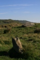
Neolithic and Bronze AgeSite Name: Grafheuvels KnegselCountry: Netherlands Province: Noord-Brabant Type: Barrow Cemetery
Nearest Town: Eindhoven Nearest Village: Knegsel
Latitude: 51.409315N Longitude: 5.354101E
Condition:
| 5 | Perfect |
| 4 | Almost Perfect |
| 3 | Reasonable but with some damage |
| 2 | Ruined but still recognisable as an ancient site |
| 1 | Pretty much destroyed, possibly visible as crop marks |
| 0 | No data. |
| -1 | Completely destroyed |
| 5 | Superb |
| 4 | Good |
| 3 | Ordinary |
| 2 | Not Good |
| 1 | Awful |
| 0 | No data. |
| 5 | Can be driven to, probably with disabled access |
| 4 | Short walk on a footpath |
| 3 | Requiring a bit more of a walk |
| 2 | A long walk |
| 1 | In the middle of nowhere, a nightmare to find |
| 0 | No data. |
| 5 | co-ordinates taken by GPS or official recorded co-ordinates |
| 4 | co-ordinates scaled from a detailed map |
| 3 | co-ordinates scaled from a bad map |
| 2 | co-ordinates of the nearest village |
| 1 | co-ordinates of the nearest town |
| 0 | no data |
Internal Links:
External Links:
")
Another small site in a very 'busy' area, between Eindhoven and the Belgian province of Antwerpen. Not so far from the Toterfout-site you'll find these three mounds dating from 1500-1000 BC.
You may be viewing yesterday's version of this page. To see the most up to date information please register for a free account.
")
")
Do not use the above information on other web sites or publications without permission of the contributor.
Nearby Images from Flickr


The above images may not be of the site on this page, but were taken nearby. They are loaded from Flickr so please click on them for image credits.
Click here to see more info for this site
Nearby sites
Click here to view sites on an interactive map of the areaKey: Red: member's photo, Blue: 3rd party photo, Yellow: other image, Green: no photo - please go there and take one, Grey: site destroyed
Download sites to:
KML (Google Earth)
GPX (GPS waypoints)
CSV (Garmin/Navman)
CSV (Excel)
To unlock full downloads you need to sign up as a Contributory Member. Otherwise downloads are limited to 50 sites.
Turn off the page maps and other distractions
Nearby sites listing. In the following links * = Image available
1.2km NW 325° Urnenveld Toterfout (46128) Cist
1.2km NW 319° Grafheuvels #1-3 Toterfout (46129) Barrow Cemetery
1.6km NW 324° Lambertsbergje - Toterfout* Barrow Cemetery
1.6km NW 321° Grafheuvel #4 Kleine Vliet (46130) Round Barrow(s)
1.6km WNW 304° Grote Aard - Toterfout* Barrow Cemetery
1.8km WNW 297° Grafheuvels Toterfout* Barrow Cemetery
2.0km WNW 289° Grafheuvels Half Mijl - Toterfout* Barrow Cemetery
2.6km S 169° Grafheuvel Steensel (525030)* Round Barrow(s)
3.3km SSE 147° Sprankel Barrow Cemetery* Barrow Cemetery
5.8km S 176° Grafheuvels Riethoven (45940) Round Barrow(s)
6.5km W 266° Zwartenberg Hoogeloon* Barrow Cemetery
7.1km NE 45° Maria Visitatiekerk* Museum
7.2km S 178° Grafheuvel Riethoven (45942) Round Barrow(s)
8.8km S 181° Grafheuvel Eerselsedijk* Barrow Cemetery
9.3km N 9° Grafheuvels Best (45077) Round Barrow(s)
9.4km SSE 154° Valentinusput (Westerhoven) Holy Well or Sacred Spring
10.7km ESE 105° Grafheuvel Ekenrooi (46183) Round Barrow(s)
13.1km ESE 106° Grafheuvel Heeze (46003) Round Barrow(s)
14.1km SSW 205° Grafheuvel Weebosch (45211) Round Barrow(s)
14.4km WNW 301° Willibrordusput (Diessen) Holy Well or Sacred Spring
17.3km W 259° Grafheuvel Hooge Mierde (45538) Round Barrow(s)
19.8km SSE 146° Grafheuvels Haarterheide* Barrow Cemetery
20.0km SSE 149° Grafheuvels Grote Haart* Barrow Cemetery
20.4km SSW 208° Steen der Zeven Heerlijkheden* Marker Stone
22.7km SSW 211° Stenencirkel op de Maat* Modern Stone Circle etc
View more nearby sites and additional images


 We would like to know more about this location. Please feel free to add a brief description and any relevant information in your own language.
 Wir möchten mehr über diese Stätte erfahren. Bitte zögern Sie nicht, eine kurze Beschreibung und relevante Informationen in Deutsch hinzuzufügen.
 Nous aimerions en savoir encore un peu sur les lieux. S'il vous plaît n'hesitez pas à ajouter une courte description et tous les renseignements pertinents dans votre propre langue.
 Quisieramos informarnos un poco más de las lugares. No dude en añadir una breve descripción y otros datos relevantes en su propio idioma.