

<< Our Photo Pages >> Hitching Stone - Natural Stone / Erratic / Other Natural Feature in England in Yorkshire (West)
Submitted by DavidRaven on Thursday, 12 August 2004 Page Views: 20108
Natural PlacesSite Name: Hitching StoneCountry: England County: Yorkshire (West) Type: Natural Stone / Erratic / Other Natural Feature
Map Ref: SD9866441706
Latitude: 53.871559N Longitude: 2.021803W
Condition:
| 5 | Perfect |
| 4 | Almost Perfect |
| 3 | Reasonable but with some damage |
| 2 | Ruined but still recognisable as an ancient site |
| 1 | Pretty much destroyed, possibly visible as crop marks |
| 0 | No data. |
| -1 | Completely destroyed |
| 5 | Superb |
| 4 | Good |
| 3 | Ordinary |
| 2 | Not Good |
| 1 | Awful |
| 0 | No data. |
| 5 | Can be driven to, probably with disabled access |
| 4 | Short walk on a footpath |
| 3 | Requiring a bit more of a walk |
| 2 | A long walk |
| 1 | In the middle of nowhere, a nightmare to find |
| 0 | No data. |
| 5 | co-ordinates taken by GPS or official recorded co-ordinates |
| 4 | co-ordinates scaled from a detailed map |
| 3 | co-ordinates scaled from a bad map |
| 2 | co-ordinates of the nearest village |
| 1 | co-ordinates of the nearest town |
| 0 | no data |
Internal Links:
External Links:
I have visited· I would like to visit
coin has visited here
")
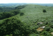
Enigmatic, impressive, and largely ignored. The search for the huge Hitching Stone took us on single-track roads through the windswept fields and moors between Yorkshire and Lancashire, south of Skipton.
From a distance the huge boulder appears tiny, though it’s actually one of the largest in Yorkshire, said to weigh in at a little over a thousand tons. As I trudged towards the rock which sits brooding over the desolate landscape here, I noticed an odd effect. Now, I’m not one for overly-fanciful musings, but the Hitching Stone seemed to grow in stature far more than I expected as I approached. From a distance it looks rather inconsequential… but as you near the place, it’s almost like it takes in a great breath and swells up! Sorry, but it’s an impression I couldn’t shake off.
The day was a typical Yorkshire summer day; windy, occasionally sunny but the sky was teeming with threatening, fast-moving, rain-promising clouds. Right on cue, (and half-expected), the clouds opened to bathe the stone in sunlight just as we arrived. It made me smile.
The most obvious feature on the rock was the hole. About eight feet from the ground, begging to be explored… Scrambling up the sheer sides, I noticed a chain had been secured to the left wall of the hole, just at the right height for grabbing as an aid to entry! The chamber went back a little over six feet. There were markings on the walls and roof that looked like the hole had been enlarged by man at some point. There was writing carved into the floor by some previous explorer. And at the far end of the chamber was the most curious thing - a ‘tube’ that entered from high on the right wall and exited opposite on the lower left wall. The tube then went all the way to the outer surface of the boulder. Geologists reckon this is caused by a fossilised tree (called Lepidodendron) that has since eroded away leaving the ‘tube’.
Sitting there in the chamber, looking across to the unmistakeable shape of Pendle Hill on the horizon, I became aware of a low resonating hum. It was barely loud enough to hear at first and reminded me of the sound made by a didgeridoo! Then it dawned on me - it was the wind, blowing over the mouth of the fossilised tree hole… Now, that did give me goosebumps! I climbed out of the hole and began to explore the southern side of the rock. With care, it was possible to climb right up to the top of the house-sized stone, where yet another surprise lay waiting. Near the upper surface, in a hole with three vertical sides and one side gently sloping to the edge, was a pool of water, around four feet wide by eight feet long… the water looked to be maybe three feet deep at the far end. Waves lapped at the rock’s surface. Surreal! A little pond atop this massive boulder?!
It struck me that this place was very ‘experiential’. I could imagine some truth-seeker from times long gone, washing in the pool, settling into the hole within the rock, listening to the trance-inducing hum of the wind past the hollow, watching the sun roll down the flanks of Pendle Hill (which it does at sunset on the equinoxes). Water (the pool), Earth (the land-fast rock itself), Air (the noise of the wind) and Fire (the setting sun)…
One local legend recorded by John Gray (1891) recounts the initiation of neophytes occurring here, the hole assuming the role of one of the many Druid or Priest Chairs found around the country. There are also two folk-tales relating to the activities of local witches. The first tells how the boulder was named and how it came to sit where it does; being ‘hitched up’ there. The second recounts how a different witch, this time on the tops of Ilkley moor, was so annoyed at having her view of the land around spoiled by this huge rock, that she stuck the handle of her broomstick into the stone, lifted it high and flung it across the valley.
Definitely not girls to get on the wrong side of…
The position the rock landed or was dumped turned out to be very significant. Not only was it used to mark the boundary between Yorkshire and Lancashire, it also marks the township boundaries of Keighley, Cowling and Sutton. The wapentakes of Staincliffe (Keighley, Settle, Skipton, Stainburn) and Skyrack (Leeds) also converge here. (The Ridings of Yorkshire were further sub-divided into administration areas called wapentakes, the word meaning an assembly or meeting place). That’s a lot of boundaries! Given that the concept of boundaries or ‘liminality’ in magic and ritual is given great importance by folks with more knowledge on these matters than me, I wonder what significance this has on the site. It was certainly important enough to host ancient councils and parliaments. It was the site of a Lammas fair until 1870, with the racing of horses nearby and curious competitions; Alec Wood wrote in 1973 of the old ‘treacle and pudding eating’ competition!
From the top of the stone we could see another rock, half a mile or so to the north-west. The map showed it to be called the ‘Winter Hill Stone’ so we set off to check it out… It’s a wind-blasted thing, from one angle it reminded me of the Doubler Stones near Addingham. On the side that faced the Hitching Stone were loads of cup markings, clustered at the base of the rock. This stone got it’s name as it’s said that the winter solstice sunrise appears from behind the Hitching Stone on the horizon. Another date for my diary - although the prospect of hanging around up here in the depths of midwinter before dawn breaks, is only bearable knowing I’ll be sustained by a tot or three of Seasonal Cheer!
You may be viewing yesterday's version of this page. To see the most up to date information please register for a free account.
")
")
")
")
")
")
")
")
")
")
")
")
")
Do not use the above information on other web sites or publications without permission of the contributor.
Click here to see more info for this site
Nearby sites
Key: Red: member's photo, Blue: 3rd party photo, Yellow: other image, Green: no photo - please go there and take one, Grey: site destroyed
Download sites to:
KML (Google Earth)
GPX (GPS waypoints)
CSV (Garmin/Navman)
CSV (Excel)
To unlock full downloads you need to sign up as a Contributory Member. Otherwise downloads are limited to 50 sites.
Turn off the page maps and other distractions
Nearby sites listing. In the following links * = Image available
462m NW 306° Winter Hill Stone* Rock Art (SD9828841976)
966m E 87° Kid Stone (Sutton Moor) Natural Stone / Erratic / Other Natural Feature (SD9963141759)
1.6km SE 130° William Walker Stone (Keighley Moor) Rock Art (SD9990440659)
1.6km NW 304° Oakworth Old Lane (Cowling) Rock Art (SD9730042625)
2.0km WSW 241° Ickornshaw Moor* Rock Art (SD9689040731)
2.0km ESE 113° Cob Stone* Rock Art (SE0055040891)
2.1km ESE 114° Grey Stones Farm Cup-Marked Rock* Rock Art (SE0061940845)
2.7km E 90° Pole Stoop (Green Sykes) Marker Stone (SE0139641683)
2.9km SSW 197° Old Bess Stone (Oakworth Moor) Standing Stone (Menhir) (SD978389)
3.0km E 81° Sutton Stoop (Tarn Lane) Marker Stone (SE0161242146)
3.2km ENE 77° Stinking Stone (Steeton) Standing Stone (Menhir) (SE0181442411)
3.7km SSW 208° Great Moss (Emmott Moor) Standing Stone (Menhir) (SD969384)
3.8km SSW 204° Watersheddles Cross* Standing Stone (Menhir) (SD9712338276)
4.2km WSW 250° Emmott Moor Rock Art (SD9475040285)
4.2km S 188° Silver Hill* Round Barrow(s) (SD981375)
4.3km ESE 111° True Well (Oakworth) Holy Well or Sacred Spring (SE02724017)
4.4km SW 225° Coombe Hill (Wycoller) Ancient Cross (SD9558638608)
4.4km ENE 61° Currer Woods Stone (Steeton)* Rock Art (SE02514384)
4.5km SE 143° Hare Hill (Oakworth) Standing Stone (Menhir) (SE014381)
4.6km E 99° Laycock Cross (Keighley)* Early Christian Sculptured Stone (SE032410)
4.7km NE 49° Nanny's Grave (Steeton) Cairn (SE022448)
4.8km NNW 342° Babyhouse Lane (Cononley) Ancient Village or Settlement (SD97194627)
4.9km NNE 31° St Andrew, Kildwick, West Yorkshire* Ancient Cross (SE0114445893)
5.0km SSW 199° Lad of Crow Hill* Not Known (by us) (SD970370)
5.0km WSW 247° Ratten Clough Cross (Emmot Moor) Ancient Cross (SD9399739746)
View more nearby sites and additional images


 We would like to know more about this location. Please feel free to add a brief description and any relevant information in your own language.
 Wir möchten mehr über diese Stätte erfahren. Bitte zögern Sie nicht, eine kurze Beschreibung und relevante Informationen in Deutsch hinzuzufügen.
 Nous aimerions en savoir encore un peu sur les lieux. S'il vous plaît n'hesitez pas à ajouter une courte description et tous les renseignements pertinents dans votre propre langue.
 Quisieramos informarnos un poco más de las lugares. No dude en añadir una breve descripción y otros datos relevantes en su propio idioma.