


<< Our Photo Pages >> Kerris Spiral Stone - Carving in England in Cornwall
Submitted by Bladup on Wednesday, 05 June 2024 Page Views: 807
Multi-periodSite Name: Kerris Spiral StoneCountry: England County: Cornwall Type: Carving
Nearest Town: Penzance
Map Ref: SW44292714
Latitude: 50.089212N Longitude: 5.576293W
Condition:
| 5 | Perfect |
| 4 | Almost Perfect |
| 3 | Reasonable but with some damage |
| 2 | Ruined but still recognisable as an ancient site |
| 1 | Pretty much destroyed, possibly visible as crop marks |
| 0 | No data. |
| -1 | Completely destroyed |
| 5 | Superb |
| 4 | Good |
| 3 | Ordinary |
| 2 | Not Good |
| 1 | Awful |
| 0 | No data. |
| 5 | Can be driven to, probably with disabled access |
| 4 | Short walk on a footpath |
| 3 | Requiring a bit more of a walk |
| 2 | A long walk |
| 1 | In the middle of nowhere, a nightmare to find |
| 0 | No data. |
| 5 | co-ordinates taken by GPS or official recorded co-ordinates |
| 4 | co-ordinates scaled from a detailed map |
| 3 | co-ordinates scaled from a bad map |
| 2 | co-ordinates of the nearest village |
| 1 | co-ordinates of the nearest town |
| 0 | no data |
Internal Links:
External Links:
")
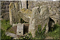
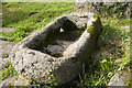
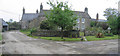
Kerris Spiral Stone is built into the side wall of a barn and is thought by some to be an ancient carved stone and by others as a re-used (from an older building) Kneeler stone. It was listed by Russell in 1971 as a carved stone with an incised spiral built into the wall of a barn at kerris, For the record I myself don't believe this stone is an ancient one but you never know!
You may be viewing yesterday's version of this page. To see the most up to date information please register for a free account.
")
")
Do not use the above information on other web sites or publications without permission of the contributor.
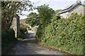
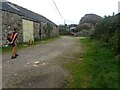
Nearby Images from Geograph Britain and Ireland:
©2012(licence)
©2021(licence)
©2012(licence)
©2012(licence)
©2006(licence)
The above images may not be of the site on this page, they are loaded from Geograph.
Please Submit an Image of this site or go out and take one for us!
Click here to see more info for this site
Nearby sites
Key: Red: member's photo, Blue: 3rd party photo, Yellow: other image, Green: no photo - please go there and take one, Grey: site destroyed
Download sites to:
KML (Google Earth)
GPX (GPS waypoints)
CSV (Garmin/Navman)
CSV (Excel)
To unlock full downloads you need to sign up as a Contributory Member. Otherwise downloads are limited to 50 sites.
Turn off the page maps and other distractions
Nearby sites listing. In the following links * = Image available
45m ENE 61° Kerris Crosses* Ancient Cross (SW44332716)
213m E 98° Kerris Settlement* Ancient Village or Settlement (SW445271)
297m NNE 17° Kerris Menhir* Standing Stone (Menhir) (SW44392742)
720m SE 132° Redhouse* Standing Stones (SW44802663)
738m NNW 349° Tresvennack Pillar* Standing Stone (Menhir) (SW44182787)
852m ENE 62° Chyenhal* Standing Stone (Menhir) (SW45062751)
913m NNE 17° Tresvennack Tumulus* Round Barrow(s) (SW446280)
989m SSE 159° Trevelloe Carn* Rock Outcrop (SW446262)
1.0km N 355° Tresvennack 2* Standing Stone (Menhir) (SW44252815)
1.0km SE 141° Trevello Stone Circle (SW449263)
1.1km NNE 16° Ennis Farm Standing Stone* Standing Stone (Menhir) (SW44652821)
1.2km W 265° Bojewans Carn* Natural Stone / Erratic / Other Natural Feature (SW431271)
1.3km NNE 31° Chyenhal Settlement Ancient Village or Settlement (SW450282)
1.3km SSW 205° Bellowal Farm Mound* Misc. Earthwork (SW437260)
1.3km NNW 331° Drift Stones* Standing Stones (SW43712831)
1.4km NE 38° Faughan* Standing Stones (SW45222822)
1.6km WNW 285° Trenuggo Cross* Ancient Cross (SW42802763)
1.6km S 173° Lamorna* Standing Stone (Menhir) (SW444255)
1.6km ENE 75° Sheffield* Standing Stone (Menhir) (SW459275)
1.7km S 182° St Ann's Well (Lamorna)* Holy Well or Sacred Spring (SW44142547)
1.7km WSW 252° Toldavas* Standing Stone (Menhir) (SW42662671)
1.7km NNW 339° Lower Drift Cross* Ancient Cross (SW43752875)
1.8km SSE 160° Castallack Round* Ancient Village or Settlement (SW44822540)
1.8km SSE 163° Castallack Carn* Standing Stone (Menhir) (SW4474025374)
1.8km N 7° Buryas Bridge menhir* Standing Stone (Menhir) (SW4459928947)
View more nearby sites and additional images


 We would like to know more about this location. Please feel free to add a brief description and any relevant information in your own language.
 Wir möchten mehr über diese Stätte erfahren. Bitte zögern Sie nicht, eine kurze Beschreibung und relevante Informationen in Deutsch hinzuzufügen.
 Nous aimerions en savoir encore un peu sur les lieux. S'il vous plaît n'hesitez pas à ajouter une courte description et tous les renseignements pertinents dans votre propre langue.
 Quisieramos informarnos un poco más de las lugares. No dude en añadir una breve descripción y otros datos relevantes en su propio idioma.