

, Aubrey Burl")
<< Our Photo Pages >> Ballachulish House - Chambered Cairn in Scotland in Highlands
Submitted by PeteCrane5 on Saturday, 17 February 2024 Page Views: 934
Neolithic and Bronze AgeSite Name: Ballachulish HouseCountry: Scotland
NOTE: This site is 3.8 km away from the location you searched for.
County: Highlands Type: Chambered Cairn
Nearest Town: Fort William Nearest Village: South Ballachulish
Map Ref: NN04885951
Latitude: 56.686467N Longitude: 5.187396W
Condition:
| 5 | Perfect |
| 4 | Almost Perfect |
| 3 | Reasonable but with some damage |
| 2 | Ruined but still recognisable as an ancient site |
| 1 | Pretty much destroyed, possibly visible as crop marks |
| 0 | No data. |
| -1 | Completely destroyed |
| 5 | Superb |
| 4 | Good |
| 3 | Ordinary |
| 2 | Not Good |
| 1 | Awful |
| 0 | No data. |
| 5 | Can be driven to, probably with disabled access |
| 4 | Short walk on a footpath |
| 3 | Requiring a bit more of a walk |
| 2 | A long walk |
| 1 | In the middle of nowhere, a nightmare to find |
| 0 | No data. |
| 5 | co-ordinates taken by GPS or official recorded co-ordinates |
| 4 | co-ordinates scaled from a detailed map |
| 3 | co-ordinates scaled from a bad map |
| 2 | co-ordinates of the nearest village |
| 1 | co-ordinates of the nearest town |
| 0 | no data |
Internal Links:
External Links:
I have visited· I would like to visit
PeteCrane5 has visited here
")
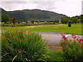
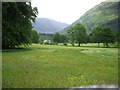
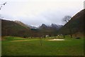
This cairn, on the edge of a golf course, is has been damaged, and only a few of the kerb stones survive, but the cist is still in situ, with a slightly dislodged capstone. It is said when excavated in 1972 no skeletal remains were found but fragments of a food vessel were along with evidence of previous disturbance.
You may be viewing yesterday's version of this page. To see the most up to date information please register for a free account.
Do not use the above information on other web sites or publications without permission of the contributor.
Nearby Images from Geograph Britain and Ireland:
©2019(licence)
©2008(licence)
©2019(licence)
©2019(licence)
©2011(licence)
The above images may not be of the site on this page, they are loaded from Geograph.
Please Submit an Image of this site or go out and take one for us!
Click here to see more info for this site
Nearby sites
Key: Red: member's photo, Blue: 3rd party photo, Yellow: other image, Green: no photo - please go there and take one, Grey: site destroyed
Download sites to:
KML (Google Earth)
GPX (GPS waypoints)
CSV (Garmin/Navman)
CSV (Excel)
To unlock full downloads you need to sign up as a Contributory Member. Otherwise downloads are limited to 50 sites.
Turn off the page maps and other distractions
Nearby sites listing. In the following links * = Image available
616m NNE 22° Rubha Mor* Cairn (NN05146007)
905m ENE 62° North Ballachulish* Rock Art (NN057599)
996m ENE 64° Bishop's Rock* Rock Art (NN058599)
2.9km NW 306° Clach-a-charra* Standing Stone (Menhir) (NN02566134)
7.9km SW 229° Achara Standing Stone* Standing Stone (Menhir) (NM98665455)
13.1km NNE 34° Dun Deardail* Vitrified Fort (NN127701)
14.7km NNE 29° Dun Dige* Round Barrow(s) (NN126720)
15.2km SE 139° Invercharnan (Glen Etive) Cairn (NN14394761)
15.2km NNE 18° West Highland Museum* Museum (NN102738)
15.8km NNE 25° Samuel's Stone* Natural Stone / Erratic / Other Natural Feature (NN122735)
16.0km SSW 203° St Cairrell's Well* Holy Well or Sacred Spring (NM980450)
17.3km SW 222° Cairnbane (Portnacroish) Chambered Cairn (NM926473)
19.3km SSW 203° Barcaldine* Standing Stones (NM96374213)
21.2km S 177° Muirheadstone* Natural Stone / Erratic / Other Natural Feature (NN050383)
21.4km SSW 206° Achacha standing stone* Standing Stone (Menhir) (NM94444075)
21.5km SSW 207° Achacha Cairn* Cairn (NM94364076)
22.6km SW 218° Eriska Crannog* Crannog (NM90114239)
23.3km W 272° Clach a' Phoanais (Strontian)* Standing Stone (Menhir) (NM8158061357)
23.6km SW 218° Balure Cairns* Cairn (NM89604145)
23.7km SSW 213° Castle Farm cairns* Cairn (NM91014029)
23.7km SSW 213° Castle Farm standing stone* Standing Stone (Menhir) (NM911402)
23.7km SW 216° Achnamoine 2* Cairn (NM89974104)
23.7km SW 215° Achnamoine Cairn* Cairn (NM90184082)
24.1km SSW 212° Culcharron cairn* Cairn (NM913396)
24.1km SW 227° Cnoc Aingil Cairn (NM86384397)
View more nearby sites and additional images


 We would like to know more about this location. Please feel free to add a brief description and any relevant information in your own language.
 Wir möchten mehr über diese Stätte erfahren. Bitte zögern Sie nicht, eine kurze Beschreibung und relevante Informationen in Deutsch hinzuzufügen.
 Nous aimerions en savoir encore un peu sur les lieux. S'il vous plaît n'hesitez pas à ajouter une courte description et tous les renseignements pertinents dans votre propre langue.
 Quisieramos informarnos un poco más de las lugares. No dude en añadir una breve descripción y otros datos relevantes en su propio idioma.