


<< Our Photo Pages >> St. Margaret's Well (Broomfield) - Holy Well or Sacred Spring in England in Kent
Submitted by DavidCWoods on Sunday, 16 October 2005 Page Views: 9845
Springs and Holy WellsSite Name: St. Margaret's Well (Broomfield)Country: England
NOTE: This site is 0.734 km away from the location you searched for.
County: Kent Type: Holy Well or Sacred Spring
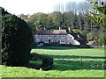
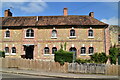
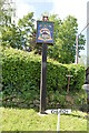
Nearest Town: Maidstone Nearest Village: Broomfield
Map Ref: TQ8390252503
Latitude: 51.242057N Longitude: 0.633293E
Condition:
| 5 | Perfect |
| 4 | Almost Perfect |
| 3 | Reasonable but with some damage |
| 2 | Ruined but still recognisable as an ancient site |
| 1 | Pretty much destroyed, possibly visible as crop marks |
| 0 | No data. |
| -1 | Completely destroyed |
| 5 | Superb |
| 4 | Good |
| 3 | Ordinary |
| 2 | Not Good |
| 1 | Awful |
| 0 | No data. |
| 5 | Can be driven to, probably with disabled access |
| 4 | Short walk on a footpath |
| 3 | Requiring a bit more of a walk |
| 2 | A long walk |
| 1 | In the middle of nowhere, a nightmare to find |
| 0 | No data. |
| 5 | co-ordinates taken by GPS or official recorded co-ordinates |
| 4 | co-ordinates scaled from a detailed map |
| 3 | co-ordinates scaled from a bad map |
| 2 | co-ordinates of the nearest village |
| 1 | co-ordinates of the nearest town |
| 0 | no data |
Internal Links:
External Links:
I have visited· I would like to visit
Majick123 visited on 5th Aug 2013 - their rating: Cond: 3 Access: 5 Lovely little well. Beautiful village
 (PID:17118)")
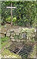
Well cared for and clearly adopted by the local church, documentary records go back to 1507. The well is surmounted by an inscribed cross and the stone lined shaft is covered by a heavy grill. A well-dressing cerimony apparently takes place here annually.
Very easy to find, the well is to be found on the main road through the village at the bottom of the path leading up to the church.
From HOLYWELL: St. Margaret's Well is easily found by taking the small road to Broomfield signposted after Leeds Castle off the A20. The well is noted as St. Margaret's and lies in the forecourt to the church, despite there being only one reference to it within a will, noted by Duncan (1906-7): ‘...to the reparation of St. Margaret's well, 12d Agnes, Widow of Ricd Caring of Leeds 1507.’
Yet, it has been remembered locally, being identified as the village dip well, laying at the edge of the church's approach road, and denoted by a white cross. The well is enclosed in a square rubble stone chamber, with a considerable depth of clear water. A black metal grille has been placed over the large opening to prevent accidents.
Since 1990, the well has been dressed on the Sunday after the Twentieth of July: the Feast day of St. Margaret. The colourful custom was transported down from Derbyshire by a Mr. Bill Withers, although the technique differs utilising plant oasis rather than puddled clay. Previous effort have had a religious topic, but 1999 celebrated the EU. The small community attends a service in the parish church, after which prayers are said at the well with the children leaving baskets of flowers.
You may be viewing yesterday's version of this page. To see the most up to date information please register for a free account.
 (PID:110954)")
 (PID:110953)")
 (PID:110952)")
 (PID:17119)")
Do not use the above information on other web sites or publications without permission of the contributor.
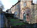
Nearby Images from Geograph Britain and Ireland:
©2005(licence)
©2020(licence)
©2022(licence)
©2022(licence)
©2013(licence)
The above images may not be of the site on this page, they are loaded from Geograph.
Please Submit an Image of this site or go out and take one for us!
Click here to see more info for this site
Nearby sites
Key: Red: member's photo, Blue: 3rd party photo, Yellow: other image, Green: no photo - please go there and take one, Grey: site destroyed
Download sites to:
KML (Google Earth)
GPX (GPS waypoints)
CSV (Garmin/Navman)
CSV (Excel)
To unlock full downloads you need to sign up as a Contributory Member. Otherwise downloads are limited to 50 sites.
Turn off the page maps and other distractions
Nearby sites listing. In the following links * = Image available
2.9km N 11° Hollingbourne Henge* Henge (TQ8434355407)
4.6km NE 38° Drake Lane Deneholes Ancient Mine, Quarry or other Industry (TQ866562)
5.1km NE 44° West Leas Denehole Ancient Mine, Quarry or other Industry (TQ873563)
5.1km NW 304° Lion of Kent Natural Stone / Erratic / Other Natural Feature (TQ7956855225)
5.1km NE 41° Drake Lane Plantation Deneholes Ancient Mine, Quarry or other Industry (TQ871565)
5.8km WSW 252° Marlpit Farm Earthworks Ancient Village or Settlement (TQ784505)
5.9km W 262° Park Wood Earthworks Ancient Village or Settlement (TQ781515)
6.1km NE 48° Park Farm Deneholes Ancient Mine, Quarry or other Industry (TQ883567)
6.4km NE 52° Oorlair Round Barrow Round Barrow(s) (TQ88885661)
7.4km WSW 256° Quarry Wood Oppidum Ancient Village or Settlement (TQ768505)
7.4km W 265° Boughton Green Settlement Ancient Village or Settlement (TQ76565158)
8.4km NW 320° Pilgrims Way 5 Ancient Trackway (TQ783588)
8.7km WNW 296° Maidstone Museum & Art Gallery* Museum (TQ7593456003)
8.7km WSW 256° Goose Well Holy Well or Sacred Spring (TQ755501)
9.4km NNW 327° Grange Farm Dene Hole Ancient Mine, Quarry or other Industry (TQ785602)
10.4km NE 38° Highsted Settlement Ancient Village or Settlement (TQ900610)
10.9km N 354° Queendown Warren Dene Holes Ancient Mine, Quarry or other Industry (TQ823633)
11.0km N 355° Queendown Warren Deneholes Ancient Mine, Quarry or other Industry (TQ826634)
11.2km NW 316° White Horse Spring* Holy Well or Sacred Spring (TQ758603)
11.4km NE 38° Highsted Gravel Pit Not Known (by us) (TQ907617)
11.6km NNW 329° Lordswood Sarsen Stones (Buxton/Iona Close)* Natural Stone / Erratic / Other Natural Feature (TQ7762262215)
11.6km NW 315° White Horse Stone* Chambered Tomb (TQ75356032)
11.6km NW 314° White Horse Stone Neolithic Longhouse Ancient Village or Settlement (TQ7525060250)
11.6km NW 312° Aylesford Megalith Long Barrow (TQ750600)
11.6km NNW 330° Lordswood Sarsen Stones* Natural Stone / Erratic / Other Natural Feature (TQ7771162358)
View more nearby sites and additional images


 We would like to know more about this location. Please feel free to add a brief description and any relevant information in your own language.
 Wir möchten mehr über diese Stätte erfahren. Bitte zögern Sie nicht, eine kurze Beschreibung und relevante Informationen in Deutsch hinzuzufügen.
 Nous aimerions en savoir encore un peu sur les lieux. S'il vous plaît n'hesitez pas à ajouter une courte description et tous les renseignements pertinents dans votre propre langue.
 Quisieramos informarnos un poco más de las lugares. No dude en añadir una breve descripción y otros datos relevantes en su propio idioma.