<< Image Pages >> Castledermot High Crosses - Ancient Cross in Ireland (Republic of) in Co. Kildare
Submitted by Sunny100 on Thursday, 16 September 2010 Page Views: 8472
Early Medieval (Dark Age)Site Name: Castledermot High Crosses Alternative Name: St Dairmuid's Cross,Country: Ireland (Republic of)
NOTE: This site is 0.256 km away from the location you searched for.
County: Co. Kildare Type: Ancient Cross
Nearest Town: Carlow Nearest Village: Castledermot
Latitude: 52.910416N Longitude: 6.834854W
Condition:
| 5 | Perfect |
| 4 | Almost Perfect |
| 3 | Reasonable but with some damage |
| 2 | Ruined but still recognisable as an ancient site |
| 1 | Pretty much destroyed, possibly visible as crop marks |
| 0 | No data. |
| -1 | Completely destroyed |
| 5 | Superb |
| 4 | Good |
| 3 | Ordinary |
| 2 | Not Good |
| 1 | Awful |
| 0 | No data. |
| 5 | Can be driven to, probably with disabled access |
| 4 | Short walk on a footpath |
| 3 | Requiring a bit more of a walk |
| 2 | A long walk |
| 1 | In the middle of nowhere, a nightmare to find |
| 0 | No data. |
| 5 | co-ordinates taken by GPS or official recorded co-ordinates |
| 4 | co-ordinates scaled from a detailed map |
| 3 | co-ordinates scaled from a bad map |
| 2 | co-ordinates of the nearest village |
| 1 | co-ordinates of the nearest town |
| 0 | no data |
Internal Links:
External Links:
I have visited· I would like to visit
X-Ice visited on 30th Jul 1982 - their rating: Cond: 4 Amb: 4 Access: 5
")
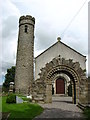
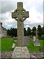
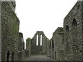
Castledermot (Dysert Diarmaid) monastic site is 6 miles NE of Carlow. In the churchyard are two 9th century high crosses and a round tower. The site dates back to 815 or 818 CE when St Dairmuid founded a monastery here. He was the son of Dairmait, high king of Ireland, and was an abbot and bishop. However, he died in 823 CE not long after founding his monastery. His feast-day is held on 23rd June.
The best preserved of the two high crosses, the North Cross, stands at 10 feet tall and is made of granite. On it's base (front) there is a hunting scene, while on the back the miracle of the loaves and fishes. The shaft (front) has panels depicting biblical scenes, including David with his harp and Adam and Eve. The central panel between the wheel-head (heaven) shows the crucifixion of Christ.
The South Cross has only the granite shaft remaining but the detail, although worn, shows Daniel in the lion's den in the lower panel (front) while the top panel has the sacrifice of Isaac; the middle panel has Celtic interlacing and spirals (front and back).
The round tower, now somewhat damaged, dates from the 10th century, and still stands at 25 metres high or 65 feet. Also the foundations of a ruined church, a reconstructed Romanesque doorway, and grave-slabs dating from the 8th-12th century.
More information at Megalithic Ireland.
You may be viewing yesterday's version of this page. To see the most up to date information please register for a free account.
")
")
Do not use the above information on other web sites or publications without permission of the contributor.
davidmorgan has found this location on Google Street View:
Nearby Images from Geograph Britain and Ireland:
©2007(licence)
©2007(licence)
©2007(licence)
©2010(licence)
©2018(licence)
The above images may not be of the site on this page, they are loaded from Geograph.
Please Submit an Image of this site or go out and take one for us!
Click here to see more info for this site
Nearby sites
Click here to view sites on an interactive map of the areaKey: Red: member's photo, Blue: 3rd party photo, Yellow: other image, Green: no photo - please go there and take one, Grey: site destroyed
Download sites to:
KML (Google Earth)
GPX (GPS waypoints)
CSV (Garmin/Navman)
CSV (Excel)
To unlock full downloads you need to sign up as a Contributory Member. Otherwise downloads are limited to 50 sites.
Turn off the page maps and other distractions
Nearby sites listing. In the following links * = Image available
7.7km N 4° Moone High Cross* Ancient Cross (S7891192693)
8.7km SSW 201° Browne’s Hill* Portal Tomb (S7538476873)
10.9km ENE 68° Baltinglass* Passage Grave (S8855289249)
13.6km ESE 122° Haroldstown* Portal Tomb (S90087793)
14.1km ENE 74° Gates Of Heaven Burial Chamber or Dolmen
14.8km SSE 158° Ardristan* Standing Stone (Menhir) (S8413871337)
15.6km ENE 75° Boleycarrigeen* Stone Circle
16.0km NE 56° Castleruddery* Stone Circle (S9159394210)
16.5km ENE 59° Castleruddery Stone Row / Alignment (S925937)
16.6km SE 137° Rathgall Destroyed Stone Circle Stone Circle (S900730)
16.7km SE 136° Rathgall Hill Fort* Hillfort (S90227315)
17.0km NNE 17° Brewel Hill Stone Circle (N833013)
17.2km NNE 31° Tournant Stone Circle (N870000)
19.1km NNE 14° Kilgowan* Standing Stone (Menhir)
19.3km WNW 289° Druids Altar (Co. Laois) Stone Circle (S600910)
20.1km ESE 117° Clonmore* Ancient Cross
20.5km WNW 295° The Ass's Manger* Cist (S5967393415)
21.0km W 276° Druids Altar (Monamanry) Ring Cairn
21.7km W 265° Slatt Lower Stone Circle (S568827)
22.1km ENE 65° The Long Stone (Knickeen)* Standing Stone (Menhir) (S983948)
22.5km NNE 13° Old Kilcullen High Cross Ancient Cross
23.1km N 10° Knockaulin Timber Circle (N820078)
23.3km NE 40° Athgreany* Stone Circle (N930032)
26.0km NE 34° Whiteleas Stone Circle
26.3km N 349° St Brigid's Holy Well Kildare* Holy Well or Sacred Spring (N73061080)
View more nearby sites and additional images


 We would like to know more about this location. Please feel free to add a brief description and any relevant information in your own language.
 Wir möchten mehr über diese Stätte erfahren. Bitte zögern Sie nicht, eine kurze Beschreibung und relevante Informationen in Deutsch hinzuzufügen.
 Nous aimerions en savoir encore un peu sur les lieux. S'il vous plaît n'hesitez pas à ajouter une courte description et tous les renseignements pertinents dans votre propre langue.
 Quisieramos informarnos un poco más de las lugares. No dude en añadir una breve descripción y otros datos relevantes en su propio idioma.