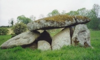
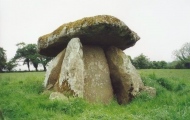
<< Our Photo Pages >> Haroldstown - Portal Tomb in Ireland (Republic of) in Co. Carlow
Submitted by Anthony_Weir on Sunday, 13 October 2002 Page Views: 8244
Neolithic and Bronze AgeSite Name: HaroldstownCountry: Ireland (Republic of)
NOTE: This site is 5.221 km away from the location you searched for.
County: Co. Carlow Type: Portal Tomb
Nearest Town: Tullow
Map Ref: S90087793
Discovery Map Number: D61
Latitude: 52.845121N Longitude: 6.663797W
Condition:
| 5 | Perfect |
| 4 | Almost Perfect |
| 3 | Reasonable but with some damage |
| 2 | Ruined but still recognisable as an ancient site |
| 1 | Pretty much destroyed, possibly visible as crop marks |
| 0 | No data. |
| -1 | Completely destroyed |
| 5 | Superb |
| 4 | Good |
| 3 | Ordinary |
| 2 | Not Good |
| 1 | Awful |
| 0 | No data. |
| 5 | Can be driven to, probably with disabled access |
| 4 | Short walk on a footpath |
| 3 | Requiring a bit more of a walk |
| 2 | A long walk |
| 1 | In the middle of nowhere, a nightmare to find |
| 0 | No data. |
| 5 | co-ordinates taken by GPS or official recorded co-ordinates |
| 4 | co-ordinates scaled from a detailed map |
| 3 | co-ordinates scaled from a bad map |
| 2 | co-ordinates of the nearest village |
| 1 | co-ordinates of the nearest town |
| 0 | no data |
Internal Links:
External Links:
I have visited· I would like to visit
DrewParsons would like to visit
bat400 visited on 11th Jul 2019 - their rating: Cond: 3 Amb: 4 Drove by only and unable to stop for a real visit.
macd visited on 1st Mar 2019 - their rating: Cond: 3 Amb: 4 Access: 3 On private land, no parking as such. As others have said, pull up on roadside but take care. Over gate into field. Get the feeling visitors are not actively encouraged. Worth a look though, even from roadside.
Average ratings for this site from all visit loggers: Condition: 3 Ambience: 4

Clearly visible in a field to the S of the old bridge over the Derreen river, this fine granite tomb has a door-slab some 1.8 metres high between the portal-stones. The larger of the 2 roofstones is much grooved and it is possible that some of the grooves are artificial as in other monuments in the area. The tomb was inhabited in the 19th century and maybe well before.
~ 2.4 km NNE in Williamstown is one of several grooved standing stones in the area, known as “The Six Fingers”. It is 1.8 metres high, of granite, and has 5 large vertical grooves.
~ 4.8 km NE (5.5 km E by S of the village of Rathvilly) in Tombeagh is another grooved granite stone, 1.5 metres high, and of grotesque shape, with grooves and depressions in it which are all natural.
You may be viewing yesterday's version of this page. To see the most up to date information please register for a free account.


Do not use the above information on other web sites or publications without permission of the contributor.
Click here to see more info for this site
Nearby sites
Click here to view sites on an interactive map of the areaKey: Red: member's photo, Blue: 3rd party photo, Yellow: other image, Green: no photo - please go there and take one, Grey: site destroyed
Download sites to:
KML (Google Earth)
GPX (GPS waypoints)
CSV (Garmin/Navman)
CSV (Excel)
To unlock full downloads you need to sign up as a Contributory Member. Otherwise downloads are limited to 50 sites.
Turn off the page maps and other distractions
Nearby sites listing. In the following links * = Image available
4.8km S 179° Rathgall Hill Fort* Hillfort (S90227315)
4.9km S 182° Rathgall Destroyed Stone Circle Stone Circle (S900730)
6.7km ESE 108° Clonmore* Ancient Cross
8.9km SW 223° Ardristan* Standing Stone (Menhir) (S8413871337)
11.3km N 11° Gates Of Heaven Burial Chamber or Dolmen
11.4km N 353° Baltinglass* Passage Grave (S8855289249)
11.8km NNE 18° Boleycarrigeen* Stone Circle
13.6km WNW 302° Castledermot High Crosses* Ancient Cross
14.7km W 267° Browne’s Hill* Portal Tomb (S7538476873)
15.9km N 10° Castleruddery Stone Row / Alignment (S925937)
16.3km N 6° Castleruddery* Stone Circle (S9159394210)
18.5km NW 324° Moone High Cross* Ancient Cross (S7891192693)
18.7km NNE 27° The Long Stone (Knickeen)* Standing Stone (Menhir) (S983948)
22.3km N 353° Tournant Stone Circle (N870000)
24.3km NNW 345° Brewel Hill Stone Circle (N833013)
25.4km N 8° Athgreany* Stone Circle (N930032)
26.7km NNW 345° Kilgowan* Standing Stone (Menhir)
27.8km NE 50° Glendalough settlement and pilgrim cross* Ancient Village or Settlement
28.9km N 6° Whiteleas Stone Circle
29.4km NE 51° The Glendalough Cross and Deer Stone* Early Christian Sculptured Stone (T126969)
29.8km N 7° Broadleas* Stone Circle (N9292507609)
29.9km NNW 347° Old Kilcullen High Cross Ancient Cross
30.9km NNW 346° Knockaulin Timber Circle (N820078)
32.7km WNW 295° Druids Altar (Co. Laois) Stone Circle (S600910)
33.5km W 279° Slatt Lower Stone Circle (S568827)
View more nearby sites and additional images


 We would like to know more about this location. Please feel free to add a brief description and any relevant information in your own language.
 Wir möchten mehr über diese Stätte erfahren. Bitte zögern Sie nicht, eine kurze Beschreibung und relevante Informationen in Deutsch hinzuzufügen.
 Nous aimerions en savoir encore un peu sur les lieux. S'il vous plaît n'hesitez pas à ajouter une courte description et tous les renseignements pertinents dans votre propre langue.
 Quisieramos informarnos un poco más de las lugares. No dude en añadir una breve descripción y otros datos relevantes en su propio idioma.