<< Our Photo Pages >> Enclosure and Hut Circle, Pont Scethin - Ancient Village or Settlement in Wales in Gwynedd
Submitted by rthomas on Tuesday, 30 June 2020 Page Views: 702
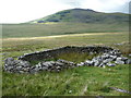
Multi-periodSite Name: Enclosure and Hut Circle, Pont Scethin Alternative Name: Pont Scethin S, SettlementCountry: Wales
NOTE: This site is 2.654 km away from the location you searched for.
County: Gwynedd Type: Ancient Village or Settlement
Nearest Village: Dyffryn Ardudwy
Map Ref: SH63502320
Latitude: 52.789057N Longitude: 4.025605W
Condition:
| 5 | Perfect |
| 4 | Almost Perfect |
| 3 | Reasonable but with some damage |
| 2 | Ruined but still recognisable as an ancient site |
| 1 | Pretty much destroyed, possibly visible as crop marks |
| 0 | No data. |
| -1 | Completely destroyed |
| 5 | Superb |
| 4 | Good |
| 3 | Ordinary |
| 2 | Not Good |
| 1 | Awful |
| 0 | No data. |
| 5 | Can be driven to, probably with disabled access |
| 4 | Short walk on a footpath |
| 3 | Requiring a bit more of a walk |
| 2 | A long walk |
| 1 | In the middle of nowhere, a nightmare to find |
| 0 | No data. |
| 5 | co-ordinates taken by GPS or official recorded co-ordinates |
| 4 | co-ordinates scaled from a detailed map |
| 3 | co-ordinates scaled from a bad map |
| 2 | co-ordinates of the nearest village |
| 1 | co-ordinates of the nearest town |
| 0 | no data |
Internal Links:
External Links:
")
From GAT2930:
"The remains of a sub-square enclosure with a single hut circle. A rectangular structure is built across the enclosure wall."
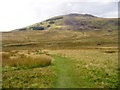
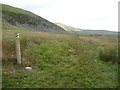
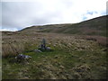
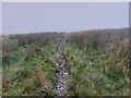
Coflein lists the site as Pont Scethin S, Settlement, although with a slightly different NGR. Even so, the site is quite easy to find as it is visible from the track.
You may be viewing yesterday's version of this page. To see the most up to date information please register for a free account.
")
")
")
Do not use the above information on other web sites or publications without permission of the contributor.
Nearby Images from Geograph Britain and Ireland:
©2005(licence)
©2011(licence)
©2015(licence)
©2023(licence)
©2011(licence)
The above images may not be of the site on this page, they are loaded from Geograph.
Please Submit an Image of this site or go out and take one for us!
Click here to see more info for this site
Nearby sites
Key: Red: member's photo, Blue: 3rd party photo, Yellow: other image, Green: no photo - please go there and take one, Grey: site destroyed
Download sites to:
KML (Google Earth)
GPX (GPS waypoints)
CSV (Garmin/Navman)
CSV (Excel)
To unlock full downloads you need to sign up as a Contributory Member. Otherwise downloads are limited to 50 sites.
Turn off the page maps and other distractions
Nearby sites listing. In the following links * = Image available
849m WNW 302° Pont Scethin B* Standing Stone (Menhir) (SH62792367)
885m WNW 298° Pont Scethin A* Standing Stone (Menhir) (SH62732364)
890m NW 316° Pont Scethin Double Cairn* Cairn (SH62902386)
931m WSW 253° Hut Circle Settlement East of Craig Y Dinas* Ancient Village or Settlement (SH62602295)
946m WNW 287° Cairns North of Craig Y Dinas* Cairn (SH626235)
1.1km WSW 258° Craig-y-Dinas (Dyffryn Ardudwy)* Hillfort (SH62432300)
1.4km SW 227° Llyn Irddyn W* Ancient Village or Settlement (SH62462229)
1.6km SW 232° Tumulus, Llyn Irddyn* Round Barrow(s) (SH62232225)
1.6km NW 326° Moelfre (Gwynedd)* Round Cairn (SH62612458)
1.6km W 267° Craig-y-Dinas W* Cairn (SH61852315)
1.7km WNW 294° Hut Group and Enclosures on SW Slope of Moelfre* Ancient Village or Settlement (SH62002391)
1.9km W 281° Cors Uchaf E Hut Group* Ancient Village or Settlement (SH61682361)
2.0km SW 232° Llyn Irddyn Hut Circle* Cairn (SH61862198)
2.2km W 265° Cors-Y-Gedol E* Cairn (SH61252305)
2.3km W 271° Cors Uchaf S* Cairn (SH61232330)
2.3km WSW 247° Ponfadog Bridge* Natural Stone / Erratic / Other Natural Feature (SH61312235)
2.4km W 262° Hut Circle, N of Afon Ysgethin* Ancient Village or Settlement (SH61062293)
2.6km WSW 241° Cairns SE from Pont Fadog* Cairn (SH612220)
2.7km SW 223° Ffridd Newydd* Stone Circle (SH61642129)
2.7km WSW 258° Pont Fadog N Hut Circles* Ancient Village or Settlement (SH60842272)
2.7km WNW 286° Waun Hir* Ring Cairn (SH609240)
2.8km WSW 237° Llecheiddior* Stone Circle (SH61112174)
2.8km NNW 340° Cwm Nantcol Tumuli* Cairn (SH626259)
2.9km WNW 288° Romano British Homestead with Enclosure, Dyffryn Ardudwy* Ancient Village or Settlement (SH60762420)
3.0km NW 305° Bron Y Foel Recumbent Stone* Portal Tomb (SH611250)
View more nearby sites and additional images


 We would like to know more about this location. Please feel free to add a brief description and any relevant information in your own language.
 Wir möchten mehr über diese Stätte erfahren. Bitte zögern Sie nicht, eine kurze Beschreibung und relevante Informationen in Deutsch hinzuzufügen.
 Nous aimerions en savoir encore un peu sur les lieux. S'il vous plaît n'hesitez pas à ajouter une courte description et tous les renseignements pertinents dans votre propre langue.
 Quisieramos informarnos un poco más de las lugares. No dude en añadir una breve descripción y otros datos relevantes en su propio idioma.