<< Our Photo Pages >> Higher Mattocks Down stone - Standing Stone (Menhir) in England in Devon
Submitted by TheCaptain on Saturday, 08 October 2011 Page Views: 2933
Neolithic and Bronze AgeSite Name: Higher Mattocks Down stoneCountry: England County: Devon Type: Standing Stone (Menhir)
Map Ref: SS60344387
Latitude: 51.176960N Longitude: 3.999339W
Condition:
| 5 | Perfect |
| 4 | Almost Perfect |
| 3 | Reasonable but with some damage |
| 2 | Ruined but still recognisable as an ancient site |
| 1 | Pretty much destroyed, possibly visible as crop marks |
| 0 | No data. |
| -1 | Completely destroyed |
| 5 | Superb |
| 4 | Good |
| 3 | Ordinary |
| 2 | Not Good |
| 1 | Awful |
| 0 | No data. |
| 5 | Can be driven to, probably with disabled access |
| 4 | Short walk on a footpath |
| 3 | Requiring a bit more of a walk |
| 2 | A long walk |
| 1 | In the middle of nowhere, a nightmare to find |
| 0 | No data. |
| 5 | co-ordinates taken by GPS or official recorded co-ordinates |
| 4 | co-ordinates scaled from a detailed map |
| 3 | co-ordinates scaled from a bad map |
| 2 | co-ordinates of the nearest village |
| 1 | co-ordinates of the nearest town |
| 0 | no data |
Internal Links:
External Links:
")
You may be viewing yesterday's version of this page. To see the most up to date information please register for a free account.
")
Do not use the above information on other web sites or publications without permission of the contributor.
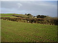
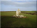
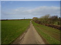
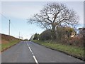
Nearby Images from Geograph Britain and Ireland:
©2012(licence)
©2012(licence)
©2012(licence)
©2015(licence)
©2023(licence)
The above images may not be of the site on this page, they are loaded from Geograph.
Please Submit an Image of this site or go out and take one for us!
Click here to see more info for this site
Nearby sites
Key: Red: member's photo, Blue: 3rd party photo, Yellow: other image, Green: no photo - please go there and take one, Grey: site destroyed
Download sites to:
KML (Google Earth)
GPX (GPS waypoints)
CSV (Garmin/Navman)
CSV (Excel)
To unlock full downloads you need to sign up as a Contributory Member. Otherwise downloads are limited to 50 sites.
Turn off the page maps and other distractions
Nearby sites listing. In the following links * = Image available
143m W 281° Mattocks Down circle Stone Circle (SS602439)
259m W 271° Mattocks Down Stone* Standing Stone (Menhir) (SS60084388)
298m W 278° Mattocks Down Stone Row Stone Row / Alignment (SS6004643921)
1.4km W 270° Mattocks Down Barrow* Long Barrow (SS589439)
3.0km N 356° Knap Down* Standing Stone (Menhir) (SS602469)
3.4km E 86° Kentisbury Down* Standing Stones (SS637440)
3.4km W 264° Berry Down Barrow Cemetery (SS569436)
3.9km E 95° Blackmoor Gate Barrows Barrow Cemetery (SS642434)
4.5km NW 314° Newberry Camp Hillfort (SS57164708)
4.5km NNW 334° Little Hangman Hill Misc. Earthwork (SS585480)
4.8km ENE 65° West Middleton Multiple Stone Rows / Avenue (SS648458)
4.9km NNE 28° Trentishoe Settlement and tumuli* Ancient Village or Settlement (SS62714811)
5.6km ENE 61° Heale Down* Standing Stone (Menhir) (SS65384645)
6.0km ESE 104° Brockenburrow Lane S Stone Row / Alignment (SS661423)
6.1km ESE 110° Friendship Farm Tumuli* Round Barrow(s) (SS660416)
6.1km WSW 257° Centery Farm Tumuli* Barrow Cemetery (SS543427)
7.4km ENE 78° Parracombe Standing Stone* Standing Stone (Menhir) (SS67654522)
8.1km WNW 297° Hillsborough* Hillfort (SS532477)
8.9km E 82° Woolhanger henge* Henge (SS692449)
9.3km SSW 200° Burridge Camp Ancient Village or Settlement (SS569352)
9.4km SSE 150° Stoke Rivers fort* Ancient Village or Settlement (SS649356)
9.4km E 92° Chapman Barrows Quincunx* Standing Stones (SS69794333)
9.4km E 91° Chapman Barrows* Barrow Cemetery (SS698435)
9.7km E 92° Chapman Down Barrow* Round Barrow(s) (SS700432)
10.2km E 93° Longstone (Challacombe)* Standing Stone (Menhir) (SS70514307)
View more nearby sites and additional images


 We would like to know more about this location. Please feel free to add a brief description and any relevant information in your own language.
 Wir möchten mehr über diese Stätte erfahren. Bitte zögern Sie nicht, eine kurze Beschreibung und relevante Informationen in Deutsch hinzuzufügen.
 Nous aimerions en savoir encore un peu sur les lieux. S'il vous plaît n'hesitez pas à ajouter une courte description et tous les renseignements pertinents dans votre propre langue.
 Quisieramos informarnos un poco más de las lugares. No dude en añadir una breve descripción y otros datos relevantes en su propio idioma.