


<< Our Photo Pages >> Hilton of Cadboll - Class I Pictish Symbol Stone in Scotland in Highlands
Submitted by cosmic on Sunday, 28 May 2006 Page Views: 10556
Early Medieval (Dark Age)Site Name: Hilton of CadbollCountry: Scotland
NOTE: This site is 4.577 km away from the location you searched for.
County: Highlands Type: Class I Pictish Symbol Stone
Nearest Town: Tain Nearest Village: Balintore
Map Ref: NH873768
Latitude: 57.766669N Longitude: 3.896095W
Condition:
| 5 | Perfect |
| 4 | Almost Perfect |
| 3 | Reasonable but with some damage |
| 2 | Ruined but still recognisable as an ancient site |
| 1 | Pretty much destroyed, possibly visible as crop marks |
| 0 | No data. |
| -1 | Completely destroyed |
| 5 | Superb |
| 4 | Good |
| 3 | Ordinary |
| 2 | Not Good |
| 1 | Awful |
| 0 | No data. |
| 5 | Can be driven to, probably with disabled access |
| 4 | Short walk on a footpath |
| 3 | Requiring a bit more of a walk |
| 2 | A long walk |
| 1 | In the middle of nowhere, a nightmare to find |
| 0 | No data. |
| 5 | co-ordinates taken by GPS or official recorded co-ordinates |
| 4 | co-ordinates scaled from a detailed map |
| 3 | co-ordinates scaled from a bad map |
| 2 | co-ordinates of the nearest village |
| 1 | co-ordinates of the nearest town |
| 0 | no data |
Internal Links:
External Links:
I have visited· I would like to visit
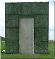
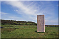
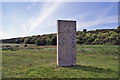
PrincessOfAvalon visited on 21st Sep 2017 - their rating: Cond: 4 Amb: 4 Quite a good atmosphere. The stone is located in a field about 1/4 mile downhill and by a sheep pasture. The stone is a faithful replica sculpture of the original (in the British Museum).
")
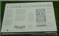
This Pictish Stone has been removed to the Museum of Scotland but a replica stands in situ. The stone itself was recycled as a grave stone with the cross side being defaced in the 17th century.
The centre piece denotes a woman riding side saddle which is taken to indicate the importance of her.
Further information at http://www.geo.ed.ac.uk/scotgaz/features/featurefirst8996.html.
You may be viewing yesterday's version of this page. To see the most up to date information please register for a free account.
")
Do not use the above information on other web sites or publications without permission of the contributor.
Nearby Images from Geograph Britain and Ireland:
©2006(licence)
©2006(licence)
©2019(licence)
©2019(licence)

©2019(licence)
The above images may not be of the site on this page, they are loaded from Geograph.
Please Submit an Image of this site or go out and take one for us!
Click here to see more info for this site
Nearby sites
Key: Red: member's photo, Blue: 3rd party photo, Yellow: other image, Green: no photo - please go there and take one, Grey: site destroyed
Download sites to:
KML (Google Earth)
GPX (GPS waypoints)
CSV (Garmin/Navman)
CSV (Excel)
To unlock full downloads you need to sign up as a Contributory Member. Otherwise downloads are limited to 50 sites.
Turn off the page maps and other distractions
Nearby sites listing. In the following links * = Image available
2.7km SW 218° Shandwick* Class II Pictish Symbol Stone (NH85557471)
8.4km NNE 28° Tarbat Discovery Centre* Museum (NH915841)
8.5km SW 232° Nigg Class II Pictish Symbol Stone* Class II Pictish Symbol Stone (NH80497170)
10.7km WNW 298° Ardjachie Farm* Rock Art (NH7802882137)
11.5km SSW 213° Fiddler's Well Holy Well or Sacred Spring (NH807673)
11.7km SSW 214° St Mary's Well (Cromarty)* Holy Well or Sacred Spring (NH805672)
12.6km W 274° Wester Lamington* Cairn (NH747780)
14.7km W 268° Scotsburn Wood East Chambered Tomb (NH726768)
14.7km W 280° Morangie Forest Chambered Cairn (NH729798)
15.2km W 268° Scotsburn Wood West Chambered Tomb (NH721767)
15.3km WNW 294° Edderton Hill Cairn (NH734834)
15.7km W 266° Scotsburn House Chambered Cairn Chambered Cairn (NH71537618)
15.8km W 266° Scotsburn House Dun* Stone Fort or Dun (NH71487616)
15.9km WNW 293° Red Burn Chambered Cairn (NH72788341)
17.0km WNW 294° Edderton 2 Class III Pictish Cross Slab (NH7190984203)
17.4km W 264° Kinrive West Chambered Cairn (NH69937538)
17.6km W 263° King's Head Cairn Chambered Cairn (NH69777513)
18.3km WNW 295° Edderton Stone Circle* Cairn (NH70908511)
18.4km WNW 295° Edderton 1* Class I Pictish Symbol Stone (NH70828507)
19.2km W 259° Newmore Wood Rock Art (NH68327366)
19.8km NNW 331° Skelbo Wood Broch or Nuraghe (NH78209443)
19.9km SW 223° Glenurquhart Grey Cairn* Cairn (NH73386247)
20.1km NW 307° Clach a' Charra* Standing Stone (Menhir) (NH7164789493)
20.7km WSW 246° Rosskeen* Class I Pictish Symbol Stone (NH6809969024)
20.9km WNW 294° Lower Lechanich South Chambered Tomb (NH684858)
View more nearby sites and additional images


 We would like to know more about this location. Please feel free to add a brief description and any relevant information in your own language.
 Wir möchten mehr über diese Stätte erfahren. Bitte zögern Sie nicht, eine kurze Beschreibung und relevante Informationen in Deutsch hinzuzufügen.
 Nous aimerions en savoir encore un peu sur les lieux. S'il vous plaît n'hesitez pas à ajouter une courte description et tous les renseignements pertinents dans votre propre langue.
 Quisieramos informarnos un poco más de las lugares. No dude en añadir una breve descripción y otros datos relevantes en su propio idioma.