<< Our Photo Pages >> Carreg Nanw - Modern Stone Circle etc in Wales in Conwy
Submitted by TAlanJones on Thursday, 20 July 2023 Page Views: 196
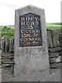
Modern SitesSite Name: Carreg NanwCountry: Wales
NOTE: This site is 1.341 km away from the location you searched for.
County: Conwy Type: Modern Stone Circle etc
Nearest Village: Rhydlydan
Map Ref: SH8940550794
Latitude: 53.042940N Longitude: 3.651059W
Condition:
| 5 | Perfect |
| 4 | Almost Perfect |
| 3 | Reasonable but with some damage |
| 2 | Ruined but still recognisable as an ancient site |
| 1 | Pretty much destroyed, possibly visible as crop marks |
| 0 | No data. |
| -1 | Completely destroyed |
| 5 | Superb |
| 4 | Good |
| 3 | Ordinary |
| 2 | Not Good |
| 1 | Awful |
| 0 | No data. |
| 5 | Can be driven to, probably with disabled access |
| 4 | Short walk on a footpath |
| 3 | Requiring a bit more of a walk |
| 2 | A long walk |
| 1 | In the middle of nowhere, a nightmare to find |
| 0 | No data. |
| 5 | co-ordinates taken by GPS or official recorded co-ordinates |
| 4 | co-ordinates scaled from a detailed map |
| 3 | co-ordinates scaled from a bad map |
| 2 | co-ordinates of the nearest village |
| 1 | co-ordinates of the nearest town |
| 0 | no data |
Internal Links:
External Links:
")
Situated within the garden of a private residence on the outskirts of Rhylydan village the stone was placed in its current position in 2011. It was removed from its previous location, i.e. the garden of the property owner's previous address at Glasfryn a few miles away. From discussions with the home owner it is believed that the stone was originally removed from a local field (date unknown) to add a little ancient mystery to the property at Glasfryn. The stone's original purpose within the field is unknown but it is suspected that it may have acted as a gate post at some stage. There is a drill hole at a height that would have accommodated a metal hinge hook.
The stone itself is weathered and very convincing as a possible maenhir. It stands at 1.68m high, 0.80m wide and 0.25m deep.
A wonderfully intriguing alternative to a garden gnome 😊
You may be viewing yesterday's version of this page. To see the most up to date information please register for a free account.
")
")
")
")
Do not use the above information on other web sites or publications without permission of the contributor.
Nearby Images from Geograph Britain and Ireland:
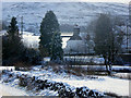
©2019(licence)
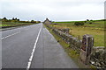
©2015(licence)
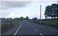
©2012(licence)
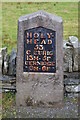
©2015(licence)
©2019(licence)
The above images may not be of the site on this page, they are loaded from Geograph.
Please Submit an Image of this site or go out and take one for us!
Click here to see more info for this site
Nearby sites
Key: Red: member's photo, Blue: 3rd party photo, Yellow: other image, Green: no photo - please go there and take one, Grey: site destroyed
Download sites to:
KML (Google Earth)
GPX (GPS waypoints)
CSV (Garmin/Navman)
CSV (Excel)
To unlock full downloads you need to sign up as a Contributory Member. Otherwise downloads are limited to 50 sites.
Turn off the page maps and other distractions
Nearby sites listing. In the following links * = Image available
2.0km SSE 160° Cefnhirfynydd Uchaf Standing Stone* Standing Stone (Menhir) (SH9004348910)
2.1km S 180° Garn Prys* Cairn (SH89374866)
2.1km SSE 152° Cefnhirfynydd Uchaf Enclosure* Ancient Village or Settlement (SH9037148889)
2.2km SSE 159° Cefnhirfynydd Uchaf Cairnfield* Barrow Cemetery (SH9016648725)
2.4km SSE 150° Cefnhirfynydd Uchaf Cairn 1* Cairn (SH9056048725)
2.4km WNW 290° Lon Mynydd Hiraethog* Ancient Trackway (SH8719051650)
2.4km SSE 150° Cefnhirfynydd Uchaf Cairn 2* Cairn (SH9054048710)
2.5km SSE 159° Cefnhirfynydd Uchaf Cairn 3* Cairn (SH9024848454)
3.0km NNW 329° Hafod Y Garreg Cist* Cist (SH8790053400)
3.0km NNW 342° Hafod y Dre* Stone Row / Alignment (SH88535371)
3.0km WNW 304° Carreg Nant Y Foel* Natural Stone / Erratic / Other Natural Feature (SH8690152540)
3.1km NNW 330° Hafod Y Carreg Cairn Field* Barrow Cemetery (SH8793053470)
3.1km NW 326° Hafod Y Garreg Earthworks and Cairns* Barrow Cemetery (SH8773053360)
3.1km SSE 154° Moel Eglwys Cairn* Cairn (SH9071348011)
3.1km NNW 328° Hafod y Garreg Row* Stone Row / Alignment (SH87815345)
3.1km NNW 329° Ffridd Can Awen Cists* Cist (SH8786053480)
3.3km NNW 328° Ffridd Can Awen Cairn* Cairn (SH8774053620)
3.3km NNE 14° Bwlch y Garnedd Hut Circle* Ancient Village or Settlement (SH90305401)
3.4km NNW 334° Cefnen Wen Cairn Field* Barrow Cemetery (SH8796053890)
3.5km S 186° Caer Garn Cairn and Round Barrow* Barrow Cemetery (SH8897047270)
3.6km NNE 16° Bwlch y Garnedd Menhir Standing Stone (Menhir) (SH9045254194)
3.6km NNW 340° Cefnen Wen Cairn East* Cairn (SH8824054160)
3.6km NNE 16° Lon Bwlch y Garnedd standing stones* Standing Stones (SH9046154197)
3.6km NNW 339° Cefnen Wen Cairn and Cist* Cairn (SH8817054170)
3.9km NNE 18° Bwlch y Garnedd Cairn 3 Cairn (SH90695450)
View more nearby sites and additional images


 We would like to know more about this location. Please feel free to add a brief description and any relevant information in your own language.
 Wir möchten mehr über diese Stätte erfahren. Bitte zögern Sie nicht, eine kurze Beschreibung und relevante Informationen in Deutsch hinzuzufügen.
 Nous aimerions en savoir encore un peu sur les lieux. S'il vous plaît n'hesitez pas à ajouter une courte description et tous les renseignements pertinents dans votre propre langue.
 Quisieramos informarnos un poco más de las lugares. No dude en añadir una breve descripción y otros datos relevantes en su propio idioma.