<< Our Photo Pages >> Deepdale Cottages - Standing Stones in Scotland in Orkney
Submitted by howar on Thursday, 03 June 2004 Page Views: 4515
Neolithic and Bronze AgeSite Name: Deepdale CottagesCountry: Scotland
NOTE: This site is 0.36 km away from the location you searched for.
County: Orkney Type: Standing Stones
Nearest Town: Finstown
Map Ref: HY267118 Landranger Map Number: 6
Latitude: 58.987025N Longitude: 3.277108W
Condition:
| 5 | Perfect |
| 4 | Almost Perfect |
| 3 | Reasonable but with some damage |
| 2 | Ruined but still recognisable as an ancient site |
| 1 | Pretty much destroyed, possibly visible as crop marks |
| 0 | No data. |
| -1 | Completely destroyed |
| 5 | Superb |
| 4 | Good |
| 3 | Ordinary |
| 2 | Not Good |
| 1 | Awful |
| 0 | No data. |
| 5 | Can be driven to, probably with disabled access |
| 4 | Short walk on a footpath |
| 3 | Requiring a bit more of a walk |
| 2 | A long walk |
| 1 | In the middle of nowhere, a nightmare to find |
| 0 | No data. |
| 5 | co-ordinates taken by GPS or official recorded co-ordinates |
| 4 | co-ordinates scaled from a detailed map |
| 3 | co-ordinates scaled from a bad map |
| 2 | co-ordinates of the nearest village |
| 1 | co-ordinates of the nearest town |
| 0 | no data |
Internal Links:
External Links:
")
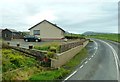
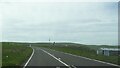
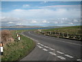
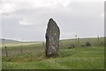
Going back about Stromness rather than through it I came to the main Kirkwall-Stromness road and thought I had a chance to finally 'do' the Deepdale Stones. Except I still got it wrong. What I had actually spotted previously were Deepdale Cottage stones. To the left of Deepdale Cottage is a short sandy-coloured standing stone and in front of it a triangular block of the same colour. There are a one or two other stones about these of different constitution and there may be some earthwork arcing about. On the opposite side of the road at Deepdale is a solitary standing stone of a different complexion, lichen-covered like many another. None on NMRS natch. Continuing around the hill you come to a large patch of rough ground and it is off the top left corner of this that the actual Deepdale Stones are located.
You may be viewing yesterday's version of this page. To see the most up to date information please register for a free account.
Do not use the above information on other web sites or publications without permission of the contributor.
Nearby Images from Geograph Britain and Ireland:
©2016(licence)
©2022(licence)
©2007(licence)

©2011(licence)
©2008(licence)
The above images may not be of the site on this page, they are loaded from Geograph.
Please Submit an Image of this site or go out and take one for us!
Click here to see more info for this site
Nearby sites
Key: Red: member's photo, Blue: 3rd party photo, Yellow: other image, Green: no photo - please go there and take one, Grey: site destroyed
Download sites to:
KML (Google Earth)
GPX (GPS waypoints)
CSV (Garmin/Navman)
CSV (Excel)
To unlock full downloads you need to sign up as a Contributory Member. Otherwise downloads are limited to 50 sites.
Turn off the page maps and other distractions
Nearby sites listing. In the following links * = Image available
498m E 89° Deepdale Stones* Standing Stone (Menhir) (HY272118)
1.3km SE 134° Howe Chambered Tomb* Chambered Tomb (HY276109)
1.5km E 90° Diamond Cottage* Promontory Fort / Cliff Castle (HY28211176)
1.6km E 92° Unstan* Chambered Cairn (HY28291172)
2.0km WNW 291° Una* Artificial Mound (HY24841254)
2.0km SE 132° Cummi Howe* Broch or Nuraghe (HY282104)
2.4km SE 132° Corn Hillock* Cairn (HY28481015)
2.9km ENE 66° Possible large stone circle in Loch of Stenness Stone Circle (HY2933112934)
2.9km NE 48° Wasbister Disc Barrow* Round Barrow(s) (HY289137)
2.9km NE 48° Dyke o'Sean* Ancient Village or Settlement (HY289137)
2.9km S 183° Quoyelsh* Ancient Village or Settlement (HY265089)
3.0km ENE 65° Fairy Well (Stenness)* Holy Well or Sacred Spring (HY2943212982)
3.0km NE 38° Bookan* Chambered Tomb (HY286141)
3.0km ENE 59° Salt Knowe* Round Barrow(s) (HY293133)
3.0km NE 48° Wasbister Burnt Mound* Artificial Mound (HY28961378)
3.0km NNE 29° Skae Frue* Round Barrow(s) (HY28241440)
3.0km NE 43° Wasbister Cairn* Cairn (HY28811397)
3.0km SE 128° The Cairns* Cairn (HY29050987)
3.0km NE 45° Bookan Cairns* Cairn (HY289139)
3.1km ENE 60° South Knowe* Artificial Mound (HY29411328)
3.1km NNE 30° Ring of Bookan* Henge (HY283145)
3.1km NE 36° The Brecks* Cairn (HY286143)
3.1km SW 217° Haley Hole Well (Brownstown) Holy Well or Sacred Spring (HY2477609314)
3.1km ENE 59° Ring of Brodgar* Stone Circle (HY29451335)
3.2km NNW 348° Voy Crannogs* Crannog (HY261149)
View more nearby sites and additional images


 We would like to know more about this location. Please feel free to add a brief description and any relevant information in your own language.
 Wir möchten mehr über diese Stätte erfahren. Bitte zögern Sie nicht, eine kurze Beschreibung und relevante Informationen in Deutsch hinzuzufügen.
 Nous aimerions en savoir encore un peu sur les lieux. S'il vous plaît n'hesitez pas à ajouter une courte description et tous les renseignements pertinents dans votre propre langue.
 Quisieramos informarnos un poco más de las lugares. No dude en añadir una breve descripción y otros datos relevantes en su propio idioma.