<< Other Photo Pages >> Modern Stones at Deeside Industrial Area - Modern Stone Circle etc in Wales in Flintshire
Submitted by Thyme7 on Monday, 24 February 2014 Page Views: 4055
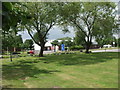
Modern SitesSite Name: Modern Stones at Deeside Industrial AreaCountry: Wales County: Flintshire Type: Modern Stone Circle etc
Nearest Village: Shotwick
Map Ref: SJ330711
Latitude: 53.232690N Longitude: 3.005203W
Condition:
| 5 | Perfect |
| 4 | Almost Perfect |
| 3 | Reasonable but with some damage |
| 2 | Ruined but still recognisable as an ancient site |
| 1 | Pretty much destroyed, possibly visible as crop marks |
| 0 | No data. |
| -1 | Completely destroyed |
| 5 | Superb |
| 4 | Good |
| 3 | Ordinary |
| 2 | Not Good |
| 1 | Awful |
| 0 | No data. |
| 5 | Can be driven to, probably with disabled access |
| 4 | Short walk on a footpath |
| 3 | Requiring a bit more of a walk |
| 2 | A long walk |
| 1 | In the middle of nowhere, a nightmare to find |
| 0 | No data. |
| 5 | co-ordinates taken by GPS or official recorded co-ordinates |
| 4 | co-ordinates scaled from a detailed map |
| 3 | co-ordinates scaled from a bad map |
| 2 | co-ordinates of the nearest village |
| 1 | co-ordinates of the nearest town |
| 0 | no data |
Internal Links:
External Links:
")
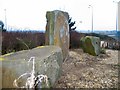
An modern arrangement of stones situated in Deeside, on a little "island" in the middle of a busy industrial estate! I've been to visit the stones and they're hidden behind a lot of bushes now.
You may be viewing yesterday's version of this page. To see the most up to date information please register for a free account.
Do not use the above information on other web sites or publications without permission of the contributor.
Andy B has found this location on Google Street View:
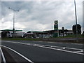
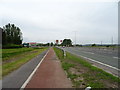
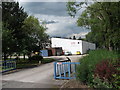
Nearby Images from Geograph Britain and Ireland:
©2006(licence)
©2012(licence)
©2019(licence)
©2012(licence)
©2012(licence)
The above images may not be of the site on this page, they are loaded from Geograph.
Please Submit an Image of this site or go out and take one for us!
Click here to see more info for this site
Nearby sites
Key: Red: member's photo, Blue: 3rd party photo, Yellow: other image, Green: no photo - please go there and take one, Grey: site destroyed
Download sites to:
KML (Google Earth)
GPX (GPS waypoints)
CSV (Garmin/Navman)
CSV (Excel)
To unlock full downloads you need to sign up as a Contributory Member. Otherwise downloads are limited to 50 sites.
Turn off the page maps and other distractions
Nearby sites listing. In the following links * = Image available
3.7km NW 311° Burton Point* Promontory Fort / Cliff Castle (SJ302736)
3.8km NNW 327° Hampston's Well* Holy Well or Sacred Spring (SJ3099074309)
7.5km NNW 328° St Mary and St Helen (Neston)* Ancient Cross (SJ29157749)
7.8km N 355° Raby Mound Round Barrow(s) (SJ32377891)
8.9km ESE 122° Dewa Roman Experience* Museum (SJ405663)
9.0km SE 124° Grosvenor Museum* Museum (SJ40466595)
9.2km ESE 122° Roman Amphitheatre (Chester)* Ancient Temple (SJ40836616)
9.2km ESE 122° Roman Garden & Hypocaust (Chester)* Ancient Village or Settlement (SJ40786607)
9.3km ESE 121° St John the Baptist Church, Chester* Ancient Cross (SJ40916613)
9.4km SE 125° Chester Minerva shrine* Ancient Temple (SJ40676561)
9.6km ESE 120° Billy Hobby's Well* Holy Well or Sacred Spring (SJ4127766202)
10.7km SE 131° Heronbridge Roman Strip Settlement Ancient Village or Settlement (SJ410639)
11.2km SW 230° Bryn-yr-Ellyllon* Round Barrow(s) (SJ2434063930)
11.3km N 9° St Barnabas (Bromborough)* Ancient Cross (SJ3491082212)
11.6km SW 234° Mold Gorsedd Circle Modern Stone Circle etc (SJ2352364421)
11.6km SW 233° Standing Stone St Mary's Church* Standing Stone (Menhir) (SJ2363864213)
11.6km ENE 72° St Mary (Thornton Le Moors)* Ancient Cross (SJ44157455)
11.7km SW 231° Mold Library and Museum* Museum (SJ237639)
11.9km N 7° St Patrick's Well (Bromborough)* Holy Well or Sacred Spring (SJ34538295)
12.0km W 260° Moel-y-Gaer Circle Timber Circle (SJ211691)
12.0km W 259° Moel-y-Gaer (Flintshire)* Hillfort (SJ21116904)
12.1km WSW 239° Rhual Isaf* Round Barrow(s) (SJ22546496)
12.5km WSW 238° Goblins Well Holy Well or Sacred Spring (SJ22256469)
12.6km SSW 192° Park in the Past* Museum (SJ301588)
12.7km E 94° St Plegmund's Well* Holy Well or Sacred Spring (SJ457701)
View more nearby sites and additional images


 We would like to know more about this location. Please feel free to add a brief description and any relevant information in your own language.
 Wir möchten mehr über diese Stätte erfahren. Bitte zögern Sie nicht, eine kurze Beschreibung und relevante Informationen in Deutsch hinzuzufügen.
 Nous aimerions en savoir encore un peu sur les lieux. S'il vous plaît n'hesitez pas à ajouter une courte description et tous les renseignements pertinents dans votre propre langue.
 Quisieramos informarnos un poco más de las lugares. No dude en añadir una breve descripción y otros datos relevantes en su propio idioma.