


<< Our Photo Pages >> Itton Cross (St Deiniol's) - Ancient Cross in Wales in Monmouthshire
Submitted by dooclay on Saturday, 20 January 2024 Page Views: 127
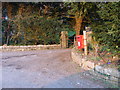
Early Medieval (Dark Age)Site Name: Itton Cross (St Deiniol's) Alternative Name: St Deiniol's Churchyard CrossCountry: Wales
NOTE: This site is 0.141 km away from the location you searched for.
County: Monmouthshire Type: Ancient Cross
Nearest Village: Itton
Map Ref: ST4933095290
Latitude: 51.654103N Longitude: 2.733835W
Condition:
| 5 | Perfect |
| 4 | Almost Perfect |
| 3 | Reasonable but with some damage |
| 2 | Ruined but still recognisable as an ancient site |
| 1 | Pretty much destroyed, possibly visible as crop marks |
| 0 | No data. |
| -1 | Completely destroyed |
| 5 | Superb |
| 4 | Good |
| 3 | Ordinary |
| 2 | Not Good |
| 1 | Awful |
| 0 | No data. |
| 5 | Can be driven to, probably with disabled access |
| 4 | Short walk on a footpath |
| 3 | Requiring a bit more of a walk |
| 2 | A long walk |
| 1 | In the middle of nowhere, a nightmare to find |
| 0 | No data. |
| 5 | co-ordinates taken by GPS or official recorded co-ordinates |
| 4 | co-ordinates scaled from a detailed map |
| 3 | co-ordinates scaled from a bad map |
| 2 | co-ordinates of the nearest village |
| 1 | co-ordinates of the nearest town |
| 0 | no data |
Internal Links:
External Links:
 (PID:268215)")
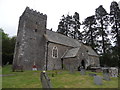
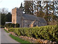
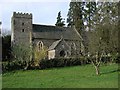
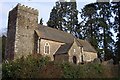
The base and part of the shaft are all that remains of this cross.
You may be viewing yesterday's version of this page. To see the most up to date information please register for a free account.
Do not use the above information on other web sites or publications without permission of the contributor.
Nearby Images from Geograph Britain and Ireland:
©2015(licence)
©2010(licence)
©2005(licence)
©2006(licence)
©2010(licence)
The above images may not be of the site on this page, they are loaded from Geograph.
Please Submit an Image of this site or go out and take one for us!
Click here to see more info for this site
Nearby sites
Key: Red: member's photo, Blue: 3rd party photo, Yellow: other image, Green: no photo - please go there and take one, Grey: site destroyed
Download sites to:
KML (Google Earth)
GPX (GPS waypoints)
CSV (Garmin/Navman)
CSV (Excel)
To unlock full downloads you need to sign up as a Contributory Member. Otherwise downloads are limited to 50 sites.
Turn off the page maps and other distractions
Nearby sites listing. In the following links * = Image available
2.2km ESE 110° Great Barnets Wood Enclosure Ancient Village or Settlement (ST51389451)
2.2km N 353° Chepstow Park Wood Cairn Cairn (ST491975)
2.7km ENE 62° St Arvan's Cross* Ancient Cross (ST517965)
2.9km ESE 112° Bishop Barnet's Camp Ancient Village or Settlement (ST520942)
3.3km SSE 159° Willis Hill Ancient Village or Settlement (ST50519216)
3.6km NE 41° Gaer Hill Camp* Hillfort (ST517980)
3.9km SW 230° Llan-melin wood Earthwork Misc. Earthwork (ST463928)
3.9km E 83° Pierce Wood Camp 2* Hillfort (ST53259572)
3.9km E 83° Piercefield Park Stone* Standing Stone (Menhir) (ST53259575)
4.2km SW 230° Llanmelin Wood* Hillfort (ST46109260)
4.3km E 81° Pierce Wood Camp 1* Hillfort (ST53619596)
4.4km ESE 104° Chepstow Museum* Museum (ST53579420)
4.8km WNW 287° y Garn Llwyd* Chambered Tomb (ST44769674)
4.8km S 176° Mathern Round Barrow(s) (ST496905)
5.1km SE 144° St Tewdric's Well* Holy Well or Sacred Spring (ST5227991167)
5.1km S 189° Crick Round Barrow* Round Barrow(s) (ST48449025)
5.1km ENE 73° Spital Meend* Promontory Fort / Cliff Castle (ST54269671)
5.1km ESE 119° The Bulwarks (Monmouthshire)* Hillfort (ST53789274)
5.1km NE 43° Blackfield Wood* Hillfort (ST529990)
5.2km ESE 119° St Peter's Cave Cave or Rock Shelter (ST539927)
5.3km SSW 206° Cult Temple at Venta Silurum* Ancient Temple (ST4695890564)
5.3km SSW 206° Venta Silurum Settlement* Ancient Village or Settlement (ST46959056)
5.4km SSW 207° Silurum Stone* Marker Stone (ST46879049)
5.6km WSW 248° Gray Hill Cairn Cemetery* Barrow Cemetery (ST4408693273)
5.8km WSW 252° Gray Hill circle* Stone Circle (ST43809353)
View more nearby sites and additional images


 We would like to know more about this location. Please feel free to add a brief description and any relevant information in your own language.
 Wir möchten mehr über diese Stätte erfahren. Bitte zögern Sie nicht, eine kurze Beschreibung und relevante Informationen in Deutsch hinzuzufügen.
 Nous aimerions en savoir encore un peu sur les lieux. S'il vous plaît n'hesitez pas à ajouter une courte description et tous les renseignements pertinents dans votre propre langue.
 Quisieramos informarnos un poco más de las lugares. No dude en añadir una breve descripción y otros datos relevantes en su propio idioma.