<< Our Photo Pages >> Holy Well (Holwell) - Holy Well or Sacred Spring in England in Dorset
Submitted by vicky on Monday, 29 March 2004 Page Views: 7926
Springs and Holy WellsSite Name: Holy Well (Holwell)Country: England County: Dorset Type: Holy Well or Sacred Spring
Nearest Town: Sherborne Nearest Village: Holwell
Map Ref: ST699121 Landranger Map Number: 194
Latitude: 50.907579N Longitude: 2.42947W
Condition:
| 5 | Perfect |
| 4 | Almost Perfect |
| 3 | Reasonable but with some damage |
| 2 | Ruined but still recognisable as an ancient site |
| 1 | Pretty much destroyed, possibly visible as crop marks |
| 0 | No data. |
| -1 | Completely destroyed |
| 5 | Superb |
| 4 | Good |
| 3 | Ordinary |
| 2 | Not Good |
| 1 | Awful |
| 0 | No data. |
| 5 | Can be driven to, probably with disabled access |
| 4 | Short walk on a footpath |
| 3 | Requiring a bit more of a walk |
| 2 | A long walk |
| 1 | In the middle of nowhere, a nightmare to find |
| 0 | No data. |
| 5 | co-ordinates taken by GPS or official recorded co-ordinates |
| 4 | co-ordinates scaled from a detailed map |
| 3 | co-ordinates scaled from a bad map |
| 2 | co-ordinates of the nearest village |
| 1 | co-ordinates of the nearest town |
| 0 | no data |
Be the first person to rate this site - see the 'Contribute!' box in the right hand menu.
Internal Links:
External Links:
 (PID:23893)")
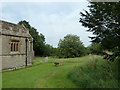
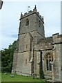
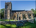
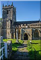
This well is located a short distance down a track behind St Lawrence’s Church, Holwell. Head down the narrow and muddy track just west of the church. Cross the Caundle Brook and about 50 yards further on the track crosses 3 concrete culverts. At this stage the well is just to the left of the track in an area that has once been fenced.
The well has steps leading down into it although at present these cannot be seen as it is filled up with silt with only the very top of the structure visible.
You may be viewing yesterday's version of this page. To see the most up to date information please register for a free account.
 (PID:242665)")
Do not use the above information on other web sites or publications without permission of the contributor.
Nearby Images from Geograph Britain and Ireland:
©2012(licence)
©2012(licence)
©2012(licence)
©2012(licence)
©2012(licence)
The above images may not be of the site on this page, they are loaded from Geograph.
Please Submit an Image of this site or go out and take one for us!
Click here to see more info for this site
Nearby sites
Key: Red: member's photo, Blue: 3rd party photo, Yellow: other image, Green: no photo - please go there and take one, Grey: site destroyed
Download sites to:
KML (Google Earth)
GPX (GPS waypoints)
CSV (Garmin/Navman)
CSV (Excel)
To unlock full downloads you need to sign up as a Contributory Member. Otherwise downloads are limited to 50 sites.
Turn off the page maps and other distractions
Nearby sites listing. In the following links * = Image available
4.8km S 190° Dungeon Hill* Hillfort (ST690074)
6.2km SSE 162° Brockhampton Green Standing Stone (Menhir) (ST718062)
8.6km S 169° Church Hill Enclosure (Alton Pancras)* Artificial Mound (ST7145403608)
8.8km WSW 243° Leigh Miz Maze* Turf Maze (ST62000818)
8.8km SSW 213° St Mary's Well (Hermitage)* Holy Well or Sacred Spring (ST651047)
9.1km E 91° Banbury Hill Hillfort (ST790119)
9.3km SSW 210° East Hill field System* Misc. Earthwork (ST65250405)
9.3km SE 132° Rawlsbury Camp* Hillfort (ST76750580)
9.6km SSW 204° Farm Hill Bowl Barrow Round Barrow(s) (ST65880334)
9.7km SSE 157° Nettlecombe Tout* Promontory Fort / Cliff Castle (ST737032)
9.8km SSW 205° High Cank Henge Henge (ST65720319)
9.8km SE 130° Bul Barrow Round Barrow(s) (ST774057)
10.1km SSE 152° Nordon Hill Tumulus* Round Barrow(s) (ST746032)
10.2km SSW 196° Bowl Barrow (Dorset) Round Barrow(s) (ST67030229)
10.3km SSW 196° Giant Hill Settlement Ancient Village or Settlement (ST66950225)
10.5km W 262° St Andrew (Yetminster) Ancient Cross (ST59421066)
10.7km SW 219° Cross and Hand Stone* Standing Stone (Menhir) (ST632038)
10.7km SSW 197° Giant Hill Bowl Barrow Round Barrow(s) (ST66760187)
10.8km SSW 197° Giant Hill Cross Ridge Dyke Misc. Earthwork (ST667018)
10.9km SSW 206° Seldon Hill Settlement Ancient Village or Settlement (ST65100235)
10.9km SSW 197° The Trendle* Misc. Earthwork (ST66730167)
10.9km SSW 197° Cerne Abbas Giant* Hill Figure or Geoglyph (ST66660168)
10.9km SSW 191° Alton Lane Field System Misc. Earthwork (ST677014)
11.2km SSW 197° St Augustine's Well (Cerne Abbas)* Holy Well or Sacred Spring (ST6664001369)
11.3km SSW 206° Wancombe Hill Field System Misc. Earthwork (ST64790200)
View more nearby sites and additional images


 We would like to know more about this location. Please feel free to add a brief description and any relevant information in your own language.
 Wir möchten mehr über diese Stätte erfahren. Bitte zögern Sie nicht, eine kurze Beschreibung und relevante Informationen in Deutsch hinzuzufügen.
 Nous aimerions en savoir encore un peu sur les lieux. S'il vous plaît n'hesitez pas à ajouter une courte description et tous les renseignements pertinents dans votre propre langue.
 Quisieramos informarnos un poco más de las lugares. No dude en añadir una breve descripción y otros datos relevantes en su propio idioma.