

<< Our Photo Pages >> Leigh Miz Maze - Turf Maze in England in Dorset
Submitted by HOLYWELL on Monday, 25 February 2008 Page Views: 9721
Multi-periodSite Name: Leigh Miz MazeCountry: England County: Dorset Type: Turf Maze
Nearest Village: Leigh
Map Ref: ST62000818
Latitude: 50.871862N Longitude: 2.541414W
Condition:
| 5 | Perfect |
| 4 | Almost Perfect |
| 3 | Reasonable but with some damage |
| 2 | Ruined but still recognisable as an ancient site |
| 1 | Pretty much destroyed, possibly visible as crop marks |
| 0 | No data. |
| -1 | Completely destroyed |
| 5 | Superb |
| 4 | Good |
| 3 | Ordinary |
| 2 | Not Good |
| 1 | Awful |
| 0 | No data. |
| 5 | Can be driven to, probably with disabled access |
| 4 | Short walk on a footpath |
| 3 | Requiring a bit more of a walk |
| 2 | A long walk |
| 1 | In the middle of nowhere, a nightmare to find |
| 0 | No data. |
| 5 | co-ordinates taken by GPS or official recorded co-ordinates |
| 4 | co-ordinates scaled from a detailed map |
| 3 | co-ordinates scaled from a bad map |
| 2 | co-ordinates of the nearest village |
| 1 | co-ordinates of the nearest town |
| 0 | no data |
Internal Links:
External Links:
I have visited· I would like to visit
X-Ice couldn't find on 1st Jan 1982 Got directions from locals. Did not search beyond that.
")
The remains of a mizmaze can still be traced and marked on the OS map. All that is left is a hexangonal earth bank which surrounded a circular labyrinth in the middle of a field. It was a meeting point for local games and was scoured even seven years by the local men. It was also the meeting place for witches and is possibly the earliest mentioned maze in documentation. It became overgrown 200 years ago.
You may be viewing yesterday's version of this page. To see the most up to date information please register for a free account.
Do not use the above information on other web sites or publications without permission of the contributor.
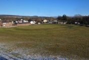
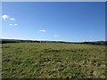
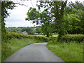
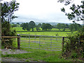
Nearby Images from Geograph Britain and Ireland:
©2016(licence)
©2017(licence)
©2017(licence)
©2008(licence)
©2011(licence)
The above images may not be of the site on this page, they are loaded from Geograph.
Please Submit an Image of this site or go out and take one for us!
Click here to see more info for this site
Nearby sites
Key: Red: member's photo, Blue: 3rd party photo, Yellow: other image, Green: no photo - please go there and take one, Grey: site destroyed
Download sites to:
KML (Google Earth)
GPX (GPS waypoints)
CSV (Garmin/Navman)
CSV (Excel)
To unlock full downloads you need to sign up as a Contributory Member. Otherwise downloads are limited to 50 sites.
Turn off the page maps and other distractions
Nearby sites listing. In the following links * = Image available
3.6km NW 314° St Andrew (Yetminster) Ancient Cross (ST59421066)
4.5km SSE 164° Cross and Hand Stone* Standing Stone (Menhir) (ST632038)
4.7km SE 138° St Mary's Well (Hermitage)* Holy Well or Sacred Spring (ST651047)
5.2km SE 141° East Hill field System* Misc. Earthwork (ST65250405)
5.6km SW 231° Evershot Stones* Standing Stones (ST57600469)
5.7km WNW 289° Closworth Cursus Cursus (ST56581008)
6.0km SW 233° St John's Well (Evershot)* Holy Well or Sacred Spring (ST5721304596)
6.2km SE 141° Farm Hill Bowl Barrow Round Barrow(s) (ST65880334)
6.2km SE 143° High Cank Henge Henge (ST65720319)
6.6km SSE 152° Seldon Hill Settlement Ancient Village or Settlement (ST65100235)
6.8km SSE 155° Wancombe Hill Field System Misc. Earthwork (ST64790200)
7.0km E 96° Dungeon Hill* Hillfort (ST690074)
7.4km SSE 152° Weam Commen Hill Field System Misc. Earthwork (ST654016)
7.7km SE 140° Giant Hill Settlement Ancient Village or Settlement (ST66950225)
7.7km SE 139° Bowl Barrow (Dorset) Round Barrow(s) (ST67030229)
7.8km SSE 160° Up Cerne/Sydling St Nicholas Boundary Stone Marker Stone (ST64610078)
7.9km SE 143° Giant Hill Bowl Barrow Round Barrow(s) (ST66760187)
7.9km SE 143° Giant Hill Cross Ridge Dyke Misc. Earthwork (ST667018)
8.0km SE 144° Cerne Abbas Giant* Hill Figure or Geoglyph (ST66660168)
8.0km SE 144° The Trendle* Misc. Earthwork (ST66730167)
8.2km SE 145° St Augustine's Well (Cerne Abbas)* Holy Well or Sacred Spring (ST6664001369)
8.5km SSW 197° The Castle Hillfort (ST594001)
8.5km S 177° The Combe (Dorset) Misc. Earthwork (SY624997)
8.7km SSE 155° Dickley Hill Bowl Barrows Round Barrow(s) (ST65600026)
8.7km SSE 155° Dickley Hill Settlement Ancient Village or Settlement (ST65650027)
View more nearby sites and additional images


 We would like to know more about this location. Please feel free to add a brief description and any relevant information in your own language.
 Wir möchten mehr über diese Stätte erfahren. Bitte zögern Sie nicht, eine kurze Beschreibung und relevante Informationen in Deutsch hinzuzufügen.
 Nous aimerions en savoir encore un peu sur les lieux. S'il vous plaît n'hesitez pas à ajouter une courte description et tous les renseignements pertinents dans votre propre langue.
 Quisieramos informarnos un poco más de las lugares. No dude en añadir una breve descripción y otros datos relevantes en su propio idioma.