

<< Our Photo Pages >> Rawlsbury Camp - Hillfort in England in Dorset
Submitted by vicky on Monday, 07 October 2002 Page Views: 22457
Iron Age and Later PrehistorySite Name: Rawlsbury CampCountry: England County: Dorset Type: Hillfort
Nearest Town: Blandford Forum Nearest Village: Ansty
Map Ref: ST76750580 Landranger Map Number: 194
Latitude: 50.851245N Longitude: 2.331645W
Condition:
| 5 | Perfect |
| 4 | Almost Perfect |
| 3 | Reasonable but with some damage |
| 2 | Ruined but still recognisable as an ancient site |
| 1 | Pretty much destroyed, possibly visible as crop marks |
| 0 | No data. |
| -1 | Completely destroyed |
| 5 | Superb |
| 4 | Good |
| 3 | Ordinary |
| 2 | Not Good |
| 1 | Awful |
| 0 | No data. |
| 5 | Can be driven to, probably with disabled access |
| 4 | Short walk on a footpath |
| 3 | Requiring a bit more of a walk |
| 2 | A long walk |
| 1 | In the middle of nowhere, a nightmare to find |
| 0 | No data. |
| 5 | co-ordinates taken by GPS or official recorded co-ordinates |
| 4 | co-ordinates scaled from a detailed map |
| 3 | co-ordinates scaled from a bad map |
| 2 | co-ordinates of the nearest village |
| 1 | co-ordinates of the nearest town |
| 0 | no data |
Internal Links:
External Links:
I have visited· I would like to visit
Andy B JimChampion have visited here
")
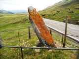
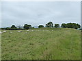
This hillfort on a spur of Bulbarrow Hill is roughly pear-shaped and encloses about 5 acres. It has two main banks with an intermediate ditch, with an entrance to the east. The earthworks around the entrance are interesting, and are confused by a medieval trackway which crosses them.
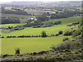
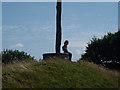
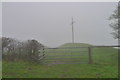
There is an unusual seat and landmark on the highest point of the hillfort, with excellent views of "Hardy Country" which actually take in five counties on a clear day.
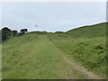
Access A bridleway skirts around south side of the ramparts, and there is a minor road to the north (coming down from Bulbarrow Hill). There is room for some road-side parking, although getting there means a confusing rural lane drive or hard uphill cycle. Nearby Bulbarrow Hill is signposted from Blandford Forum.
You may be viewing yesterday's version of this page. To see the most up to date information please register for a free account.
")
")
")
Do not use the above information on other web sites or publications without permission of the contributor.
Nearby Images from Geograph Britain and Ireland:
©2015(licence)
©2005(licence)
©2006(licence)
©2015(licence)
©2019(licence)
The above images may not be of the site on this page, they are loaded from Geograph.
Please Submit an Image of this site or go out and take one for us!
Click here to see more info for this site
Nearby sites
Key: Red: member's photo, Blue: 3rd party photo, Yellow: other image, Green: no photo - please go there and take one, Grey: site destroyed
Download sites to:
KML (Google Earth)
GPX (GPS waypoints)
CSV (Garmin/Navman)
CSV (Excel)
To unlock full downloads you need to sign up as a Contributory Member. Otherwise downloads are limited to 50 sites.
Turn off the page maps and other distractions
Nearby sites listing. In the following links * = Image available
656m E 99° Bul Barrow Round Barrow(s) (ST774057)
3.4km SW 219° Nordon Hill Tumulus* Round Barrow(s) (ST746032)
4.0km SW 229° Nettlecombe Tout* Promontory Fort / Cliff Castle (ST737032)
4.2km SSW 194° Giant's Grave Sarsen Stone* Standing Stone (Menhir) (ST757017)
5.0km W 274° Brockhampton Green Standing Stone (Menhir) (ST718062)
5.0km NE 56° Ringmoor Settlement* Ancient Village or Settlement (ST809086)
5.7km WSW 247° Church Hill Enclosure (Alton Pancras)* Artificial Mound (ST7145403608)
6.5km NNE 20° Banbury Hill Hillfort (ST790119)
6.9km SSW 204° Cheselbourne Round Barrow(s) (SY739995)
7.9km WNW 281° Dungeon Hill* Hillfort (ST690074)
8.6km SE 142° Deverel Barrow* Round Barrow(s) (SY820990)
9.1km ESE 114° Combs Ditch Ancient Village or Settlement (ST851021)
9.3km NW 312° Holy Well (Holwell)* Holy Well or Sacred Spring (ST699121)
10.0km WSW 244° Alton Lane Field System Misc. Earthwork (ST677014)
10.0km ENE 61° Hod Hill* Hillfort (ST856106)
10.1km NE 52° Southern cross-dyke* Misc. Earthwork (ST84791202)
10.2km NE 52° Hambledon Hill long barrow* Long Barrow (ST84891205)
10.3km NE 51° Hambledon Hill enclosure* Causewayed Enclosure (ST848122)
10.3km WSW 250° Bowl Barrow (Dorset) Round Barrow(s) (ST67030229)
10.3km NE 48° Hambledon Hill long barrow Long Barrow (ST84511265)
10.4km NE 56° Stepleton Enclosure Causewayed Enclosure (ST8540311526)
10.4km NE 48° Hambledon Hill hillfort* Hillfort (ST84511270)
10.4km SSE 157° Weatherby Castle* Hillfort (SY807962)
10.4km NE 47° Hambledon Hillfort Spur Enclosure Misc. Earthwork (ST84351290)
10.4km WSW 250° Giant Hill Settlement Ancient Village or Settlement (ST66950225)
View more nearby sites and additional images


 We would like to know more about this location. Please feel free to add a brief description and any relevant information in your own language.
 Wir möchten mehr über diese Stätte erfahren. Bitte zögern Sie nicht, eine kurze Beschreibung und relevante Informationen in Deutsch hinzuzufügen.
 Nous aimerions en savoir encore un peu sur les lieux. S'il vous plaît n'hesitez pas à ajouter une courte description et tous les renseignements pertinents dans votre propre langue.
 Quisieramos informarnos un poco más de las lugares. No dude en añadir una breve descripción y otros datos relevantes en su propio idioma.