<< Our Photo Pages >> Rostherne Celtic Head - Sculptured Stone in England in Cheshire
Submitted by vicky on Monday, 23 February 2004 Page Views: 14734
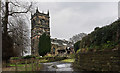
Multi-periodSite Name: Rostherne Celtic HeadCountry: England County: Cheshire Type: Sculptured Stone
Nearest Town: Knutsford Nearest Village: Rostherne
Map Ref: SJ743837 Landranger Map Number: 109
Latitude: 53.349559N Longitude: 2.387529W
Condition:
| 5 | Perfect |
| 4 | Almost Perfect |
| 3 | Reasonable but with some damage |
| 2 | Ruined but still recognisable as an ancient site |
| 1 | Pretty much destroyed, possibly visible as crop marks |
| 0 | No data. |
| -1 | Completely destroyed |
| 5 | Superb |
| 4 | Good |
| 3 | Ordinary |
| 2 | Not Good |
| 1 | Awful |
| 0 | No data. |
| 5 | Can be driven to, probably with disabled access |
| 4 | Short walk on a footpath |
| 3 | Requiring a bit more of a walk |
| 2 | A long walk |
| 1 | In the middle of nowhere, a nightmare to find |
| 0 | No data. |
| 5 | co-ordinates taken by GPS or official recorded co-ordinates |
| 4 | co-ordinates scaled from a detailed map |
| 3 | co-ordinates scaled from a bad map |
| 2 | co-ordinates of the nearest village |
| 1 | co-ordinates of the nearest town |
| 0 | no data |
Internal Links:
External Links:
I have visited· I would like to visit
TimPrevett has visited here
")
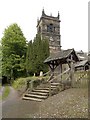
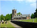
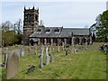
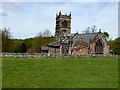
This supposed Celtic Head lies to the rear of the Church in Rostherne near Knutsford. It is carved into a block of sandstone and has either hair or horns on either side of its face leading to speculation that it may be associated with Cernunnos, the horned god, after which the Cornovii tribe took their name. It was reputedly pulled out of the nearby Rostherne Mere which reputedly has a mermaid and may have come from a shrine.
You may be viewing yesterday's version of this page. To see the most up to date information please register for a free account.
")
")
")
Do not use the above information on other web sites or publications without permission of the contributor.
Nearby Images from Geograph Britain and Ireland:
©2010(licence)
©2008(licence)
©2015(licence)
©2015(licence)
©2016(licence)
The above images may not be of the site on this page, they are loaded from Geograph.
Please Submit an Image of this site or go out and take one for us!
Click here to see more info for this site
Nearby sites
Key: Red: member's photo, Blue: 3rd party photo, Yellow: other image, Green: no photo - please go there and take one, Grey: site destroyed
Download sites to:
KML (Google Earth)
GPX (GPS waypoints)
CSV (Garmin/Navman)
CSV (Excel)
To unlock full downloads you need to sign up as a Contributory Member. Otherwise downloads are limited to 50 sites.
Turn off the page maps and other distractions
Nearby sites listing. In the following links * = Image available
2.2km WSW 239° Bucklow Hill* Round Barrow(s) (SJ7235582567)
2.6km SSE 147° Tatton Iron Age roundhouse and pit* Ancient Village or Settlement (SJ757815)
2.7km NW 325° Arthill Heath Farm Ancient Village or Settlement (SJ728859)
2.7km SSE 148° Tatton Neolithic posthole and pit* Ancient Village or Settlement (SJ757814)
2.8km SSE 157° Tatton Neolithic hearth* Ancient Village or Settlement (SJ754811)
3.1km NNW 336° Fairy Brow Round Barrow(s) (SJ73088654)
5.3km W 264° Legh Oaks Farm Ancient Village or Settlement (SJ690832)
5.4km SSE 166° Nether Knutsford* Round Barrow(s) (SJ756785)
7.6km ESE 119° Lindow* Ancient Trackway (SJ810800)
10.0km SW 234° Robin Hoods Butts Round Barrow(s) (SJ662778)
10.2km NNW 334° Great Woolden Hall Ancient Village or Settlement (SJ698929)
11.1km NNW 332° Great Woolden Hall Farm* Hillfort (SJ691935)
12.0km SE 145° Astle Park Round Barrow(s) (SJ811738)
12.3km NW 307° The Birchwood Monolith* Modern Stone Circle etc (SJ64409110)
12.4km ENE 66° St Mary (Cheadle, Stockport) Ancient Cross (SJ85668864)
12.9km ESE 117° Wizard's Well* Holy Well or Sacred Spring (SJ858778)
12.9km ESE 117° Armada Beacon* Round Barrow(s) (SJ858777)
13.0km ESE 116° Holy Well (Alderley Edge)* Holy Well or Sacred Spring (SJ85907786)
13.0km SSE 150° Old Withington* Barrow Cemetery (SJ80677240)
13.0km ESE 115° Findlow Marker Stone (SJ86027808)
13.1km ESE 116° Druidical Circle* Modern Stone Circle etc (SJ86077788)
13.1km ESE 117° Wishing Well (Alderley Edge)* Holy Well or Sacred Spring (SJ860777)
13.1km ESE 116° Wizard's Cave Cave or Rock Shelter (SJ86087782)
13.3km ESE 117° Engine Vein, Alderley Edge Copper Mines* Ancient Mine, Quarry or other Industry (SJ861776)
13.3km ESE 117° Golden Stone (Alderley Edge)* Standing Stone (Menhir) (SJ861776)
View more nearby sites and additional images


 We would like to know more about this location. Please feel free to add a brief description and any relevant information in your own language.
 Wir möchten mehr über diese Stätte erfahren. Bitte zögern Sie nicht, eine kurze Beschreibung und relevante Informationen in Deutsch hinzuzufügen.
 Nous aimerions en savoir encore un peu sur les lieux. S'il vous plaît n'hesitez pas à ajouter une courte description et tous les renseignements pertinents dans votre propre langue.
 Quisieramos informarnos un poco más de las lugares. No dude en añadir una breve descripción y otros datos relevantes en su propio idioma.