


<< Text Pages >> Eilean Musdile (Lismore) - Standing Stone (Menhir) in Scotland in Argyll
Submitted by Anne T on Thursday, 12 October 2017 Page Views: 1545
Neolithic and Bronze AgeSite Name: Eilean Musdile (Lismore)Country: Scotland County: Argyll Type: Standing Stone (Menhir)
Nearest Village: Lismore
Map Ref: NM779351
Latitude: 56.455570N Longitude: 5.606058W
Condition:
| 5 | Perfect |
| 4 | Almost Perfect |
| 3 | Reasonable but with some damage |
| 2 | Ruined but still recognisable as an ancient site |
| 1 | Pretty much destroyed, possibly visible as crop marks |
| 0 | No data. |
| -1 | Completely destroyed |
| 5 | Superb |
| 4 | Good |
| 3 | Ordinary |
| 2 | Not Good |
| 1 | Awful |
| 0 | No data. |
| 5 | Can be driven to, probably with disabled access |
| 4 | Short walk on a footpath |
| 3 | Requiring a bit more of a walk |
| 2 | A long walk |
| 1 | In the middle of nowhere, a nightmare to find |
| 0 | No data. |
| 5 | co-ordinates taken by GPS or official recorded co-ordinates |
| 4 | co-ordinates scaled from a detailed map |
| 3 | co-ordinates scaled from a bad map |
| 2 | co-ordinates of the nearest village |
| 1 | co-ordinates of the nearest town |
| 0 | no data |
Internal Links:
External Links:
Standing Stone (Menhir) in Argyll
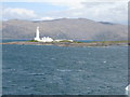
This now destroyed standing stone is recorded as Canmore ID 22659 and The Northern Antiquarian's page for Eilean Musdile, Lismore, Argyll.
Canmore tells us that "in 1784, an unworked pillar of grey granite, measuring 0.9 metres in breadth, 0.6 metres in average thickness and 2.75 metres in height stood on the highest point of Eilean Musdile. It was probably removed during the building operations for the construction of the lighthouse in 1833."
The Northern Antiquarian adds that "First described by a traveller here in 1784, it was mentioned just once again during survey work in 1829. The monolith appears to have recorded the midwinter sunset."
Note: Do you have any more information about this standing stone? Do you have any historical drawings?
You may be viewing yesterday's version of this page. To see the most up to date information please register for a free account.
Do not use the above information on other web sites or publications without permission of the contributor.
Nearby Images from Geograph Britain and Ireland:

©2006(licence)

©2014(licence)
©2012(licence)

©2010(licence)

©2015(licence)
The above images may not be of the site on this page, they are loaded from Geograph.
Please Submit an Image of this site or go out and take one for us!
Click here to see more info for this site
Nearby sites
Key: Red: member's photo, Blue: 3rd party photo, Yellow: other image, Green: no photo - please go there and take one, Grey: site destroyed
Download sites to:
KML (Google Earth)
GPX (GPS waypoints)
CSV (Garmin/Navman)
CSV (Excel)
To unlock full downloads you need to sign up as a Contributory Member. Otherwise downloads are limited to 50 sites.
Turn off the page maps and other distractions
Nearby sites listing. In the following links * = Image available
1.6km NE 54° Dun Chruban* Stone Fort or Dun (NM79243598)
2.5km NE 53° An Dun 2 (Lismore)* Stone Fort or Dun (NM79983651)
3.3km NE 54° Fiart Dun* Stone Fort or Dun (NM80673687)
3.3km NE 41° Aon Garbh Cairns* Cairn (NM80213751)
3.6km NE 40° Aon Garbh Cist* Cist (NM80393772)
4.1km NE 48° An Dun Broch* Broch or Nuraghe (NM81133768)
5.2km NE 41° Barr Mor* Cairn (NM81493886)
5.3km WSW 257° Duart Stone Setting* Standing Stones (NM727342)
5.3km WSW 257° Duart Standing Stone* Standing Stone (Menhir) (NM72653421)
5.4km NE 50° Kilcheran Dun* Stone Fort or Dun (NM82213834)
6.0km NE 49° Kilcheran Fort* Hillfort (NM82663877)
6.5km SE 138° Slatrach Cairn Cairn (NM82043002)
6.8km NE 39° Dun Cuilein* Stone Fort or Dun (NM82504018)
6.9km SE 140° Sidhean Riabhach* Cist (NM82092959)
7.1km SSW 213° Port Donain Cairn* Cairn (NM73672932)
7.2km SSW 212° Port Donain Chambered Cairn* Chambered Cairn (NM73752925)
7.2km NE 50° Balygrundle South* Cairn (NM83653946)
7.5km NE 47° Balygrundle North* Cairn (NM83673997)
7.6km NE 51° Dun Vamha Chradha* Cairn (NM84023958)
7.6km NE 47° Dun Mor (Lismore)* Stone Fort or Dun (NM83724003)
8.1km ESE 113° Dunollie Stone Fort or Dun (NM85223148)
8.2km NE 50° Sean Dun (Lismore)* Stone Fort or Dun (NM84483996)
8.4km ESE 116° Oban cup marked stone* Rock Art (NM85243097)
8.5km WNW 289° Scallastle* Stone Row / Alignment (NM6998438286)
8.8km SE 127° Carding Mill Bay Mesolithic Shell Middens* Cist (NM8470029400)
View more nearby sites and additional images


 We would like to know more about this location. Please feel free to add a brief description and any relevant information in your own language.
 Wir möchten mehr über diese Stätte erfahren. Bitte zögern Sie nicht, eine kurze Beschreibung und relevante Informationen in Deutsch hinzuzufügen.
 Nous aimerions en savoir encore un peu sur les lieux. S'il vous plaît n'hesitez pas à ajouter une courte description et tous les renseignements pertinents dans votre propre langue.
 Quisieramos informarnos un poco más de las lugares. No dude en añadir una breve descripción y otros datos relevantes en su propio idioma.