

<< Our Photo Pages >> Scallastle - Stone Row / Alignment in Scotland in Isle of Mull
Submitted by Nick on Sunday, 02 November 2003 Page Views: 9441
Neolithic and Bronze AgeSite Name: ScallastleCountry: Scotland County: Isle of Mull Type: Stone Row / Alignment
Nearest Village: Scallastle
Map Ref: NM6998438286 Landranger Map Number: 49
Latitude: 56.480338N Longitude: 5.737032W
Condition:
| 5 | Perfect |
| 4 | Almost Perfect |
| 3 | Reasonable but with some damage |
| 2 | Ruined but still recognisable as an ancient site |
| 1 | Pretty much destroyed, possibly visible as crop marks |
| 0 | No data. |
| -1 | Completely destroyed |
| 5 | Superb |
| 4 | Good |
| 3 | Ordinary |
| 2 | Not Good |
| 1 | Awful |
| 0 | No data. |
| 5 | Can be driven to, probably with disabled access |
| 4 | Short walk on a footpath |
| 3 | Requiring a bit more of a walk |
| 2 | A long walk |
| 1 | In the middle of nowhere, a nightmare to find |
| 0 | No data. |
| 5 | co-ordinates taken by GPS or official recorded co-ordinates |
| 4 | co-ordinates scaled from a detailed map |
| 3 | co-ordinates scaled from a bad map |
| 2 | co-ordinates of the nearest village |
| 1 | co-ordinates of the nearest town |
| 0 | no data |
Internal Links:
External Links:
I have visited· I would like to visit
jimstone would like to visit
SandyG visited on 3rd Jun 2016 - their rating: Cond: 2 Amb: 4 Access: 4 Car parking is available at NM 70110 38516. From here carefully walk along the road to NM 70246 38469 and then follow the track towards the stones.
tom_bullock have visited here
")
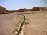
Ask permission at the farm, parking is easy at the road end as there is plenty of room. Not visible from the road from Craignure, you can only see this heading south from Salen. Set out on a low mound, with a couple of possible kerb stones still in situ, there is one upright stone (about 1.3m tall) and one recumbent here. The 'kerb stones' may in fact be other recumbents - it's a bit hard to tell. Have a look at the photograph and make your own mind up! The stones are aligned NW/SE. There are no significant markings on any of the stones.
Update November 2019: This alignment is featured on the Stone Rows of Great Britain website - see their entry for Scallastle, which includes a description, a plan of the row from a survey carried out in June 2016, photographs of the alignment and its individual stones, access information and a list of online resources for more information. The SRoGB notes that the slight mound from which the stone protrude has been formed by later cultivation.
The row is also recorded as Canmore ID 22404 (Mull, Scallastle), which adds that the site is in a flat (arable) field about a furlong from the shore.
You may be viewing yesterday's version of this page. To see the most up to date information please register for a free account.
")
")
")
")
")
")
")
")
")
")
")
")
")
")
")
")
")
")
Do not use the above information on other web sites or publications without permission of the contributor.
Click here to see more info for this site
Nearby sites
Key: Red: member's photo, Blue: 3rd party photo, Yellow: other image, Green: no photo - please go there and take one, Grey: site destroyed
Download sites to:
KML (Google Earth)
GPX (GPS waypoints)
CSV (Garmin/Navman)
CSV (Excel)
To unlock full downloads you need to sign up as a Contributory Member. Otherwise downloads are limited to 50 sites.
![]()
![]()
Turn off the page maps and other distractions
Nearby sites listing. In the following links * = Image available
4.9km SE 144° Duart Standing Stone* Standing Stone (Menhir) (NM72653421)
4.9km SE 143° Duart Stone Setting* Standing Stones (NM727342)
8.5km ESE 109° Eilean Musdile (Lismore) Standing Stone (Menhir) (NM779351)
9.5km E 101° Dun Chruban* Stone Fort or Dun (NM79243598)
9.7km SSE 155° Port Donain Cairn* Cairn (NM73672932)
9.8km SSE 154° Port Donain Chambered Cairn* Chambered Cairn (NM73752925)
10.1km E 97° An Dun 2 (Lismore)* Stone Fort or Dun (NM79983651)
10.2km E 91° Aon Garbh Cairns* Cairn (NM80213751)
10.4km E 90° Aon Garbh Cist* Cist (NM80393772)
10.7km E 94° Fiart Dun* Stone Fort or Dun (NM80673687)
11.0km N 356° Claggan* Cairn (NM69794930)
11.1km E 90° An Dun Broch* Broch or Nuraghe (NM81133768)
11.5km E 84° Barr Mor* Cairn (NM81493886)
12.2km E 87° Kilcheran Dun* Stone Fort or Dun (NM82213834)
12.2km N 356° Acharn South* Cairn (NM698505)
12.2km N 11° Gleann Geal* Cairn (NM73015013)
12.6km ENE 78° Dun Cuilein* Stone Fort or Dun (NM82504018)
12.6km E 85° Kilcheran Fort* Hillfort (NM82663877)
13.7km E 82° Balygrundle South* Cairn (NM83653946)
13.7km E 80° Balygrundle North* Cairn (NM83673997)
13.8km E 80° Dun Mor (Lismore)* Stone Fort or Dun (NM83724003)
14.0km E 82° Dun Vamha Chradha* Cairn (NM84023958)
14.5km E 80° Sean Dun (Lismore)* Stone Fort or Dun (NM84483996)
14.6km ESE 121° Slatrach Cairn Cairn (NM82043002)
14.9km ESE 123° Sidhean Riabhach* Cist (NM82092959)
View more nearby sites and additional images


 We would like to know more about this location. Please feel free to add a brief description and any relevant information in your own language.
 Wir möchten mehr über diese Stätte erfahren. Bitte zögern Sie nicht, eine kurze Beschreibung und relevante Informationen in Deutsch hinzuzufügen.
 Nous aimerions en savoir encore un peu sur les lieux. S'il vous plaît n'hesitez pas à ajouter une courte description et tous les renseignements pertinents dans votre propre langue.
 Quisieramos informarnos un poco más de las lugares. No dude en añadir una breve descripción y otros datos relevantes en su propio idioma.