

<< Our Photo Pages >> Aon Garbh Cist - Cist in Scotland in Argyll
Submitted by SolarMegalith on Monday, 30 October 2023 Page Views: 159
Neolithic and Bronze AgeSite Name: Aon Garbh CistCountry: Scotland County: Argyll Type: Cist
Nearest Town: Oban Nearest Village: Achnacroish
Map Ref: NM80393772
Latitude: 56.480229N Longitude: 5.567942W
Condition:
| 5 | Perfect |
| 4 | Almost Perfect |
| 3 | Reasonable but with some damage |
| 2 | Ruined but still recognisable as an ancient site |
| 1 | Pretty much destroyed, possibly visible as crop marks |
| 0 | No data. |
| -1 | Completely destroyed |
| 5 | Superb |
| 4 | Good |
| 3 | Ordinary |
| 2 | Not Good |
| 1 | Awful |
| 0 | No data. |
| 5 | Can be driven to, probably with disabled access |
| 4 | Short walk on a footpath |
| 3 | Requiring a bit more of a walk |
| 2 | A long walk |
| 1 | In the middle of nowhere, a nightmare to find |
| 0 | No data. |
| 5 | co-ordinates taken by GPS or official recorded co-ordinates |
| 4 | co-ordinates scaled from a detailed map |
| 3 | co-ordinates scaled from a bad map |
| 2 | co-ordinates of the nearest village |
| 1 | co-ordinates of the nearest town |
| 0 | no data |
Internal Links:
External Links:
I have visited· I would like to visit
SolarMegalith visited on 13th Feb 2023 - their rating: Cond: 3 Amb: 5 Access: 3
")
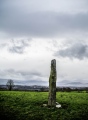
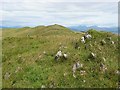
A small cist (0.9 x 0.5m of internal dimensions), likely prehistoric, is located in a slight hollow in the northern part of Aon Garbh ridge. It is made of upright stones and lacks capstone.
Canmore entry
You may be viewing yesterday's version of this page. To see the most up to date information please register for a free account.
")
Do not use the above information on other web sites or publications without permission of the contributor.
Nearby Images from Geograph Britain and Ireland:
©2022(licence)
©2019(licence)
©2021(licence)
©2021(licence)
©2009(licence)
The above images may not be of the site on this page, they are loaded from Geograph.
Please Submit an Image of this site or go out and take one for us!
Click here to see more info for this site
Nearby sites
Key: Red: member's photo, Blue: 3rd party photo, Yellow: other image, Green: no photo - please go there and take one, Grey: site destroyed
Download sites to:
KML (Google Earth)
GPX (GPS waypoints)
CSV (Garmin/Navman)
CSV (Excel)
To unlock full downloads you need to sign up as a Contributory Member. Otherwise downloads are limited to 50 sites.
Turn off the page maps and other distractions
Nearby sites listing. In the following links * = Image available
276m SW 218° Aon Garbh Cairns* Cairn (NM80213751)
738m E 90° An Dun Broch* Broch or Nuraghe (NM81133768)
893m SSE 159° Fiart Dun* Stone Fort or Dun (NM80673687)
1.3km SSW 196° An Dun 2 (Lismore)* Stone Fort or Dun (NM79983651)
1.6km NE 41° Barr Mor* Cairn (NM81493886)
1.9km ENE 68° Kilcheran Dun* Stone Fort or Dun (NM82213834)
2.1km SSW 210° Dun Chruban* Stone Fort or Dun (NM79243598)
2.5km ENE 62° Kilcheran Fort* Hillfort (NM82663877)
3.2km NE 38° Dun Cuilein* Stone Fort or Dun (NM82504018)
3.6km SW 221° Eilean Musdile (Lismore) Standing Stone (Menhir) (NM779351)
3.7km ENE 59° Balygrundle South* Cairn (NM83653946)
4.0km NE 53° Balygrundle North* Cairn (NM83673997)
4.0km NE 52° Dun Mor (Lismore)* Stone Fort or Dun (NM83724003)
4.1km ENE 60° Dun Vamha Chradha* Cairn (NM84023958)
4.6km ENE 58° Sean Dun (Lismore)* Stone Fort or Dun (NM84483996)
7.9km SSE 165° Slatrach Cairn Cairn (NM82043002)
7.9km SE 139° Dunollie Stone Fort or Dun (NM85223148)
8.0km NE 41° Carn Mor (Lismore)* Cairn (NM85934354)
8.0km NE 42° Clach na h-ealea (Clachan)* Natural Stone / Erratic / Other Natural Feature (NM86094342)
8.1km NE 42° Lismore Grave Slabs* Sculptured Stone (NM8608043445)
8.2km ESE 114° Dunstaffnage Round Houses* Ancient Village or Settlement (NM877340)
8.2km NE 48° Tirefour Castle* Broch or Nuraghe (NM8675542912)
8.3km SSE 165° Sidhean Riabhach* Cist (NM82092959)
8.3km SE 141° Oban cup marked stone* Rock Art (NM85243097)
8.4km WSW 242° Duart Stone Setting* Standing Stones (NM727342)
View more nearby sites and additional images


 We would like to know more about this location. Please feel free to add a brief description and any relevant information in your own language.
 Wir möchten mehr über diese Stätte erfahren. Bitte zögern Sie nicht, eine kurze Beschreibung und relevante Informationen in Deutsch hinzuzufügen.
 Nous aimerions en savoir encore un peu sur les lieux. S'il vous plaît n'hesitez pas à ajouter une courte description et tous les renseignements pertinents dans votre propre langue.
 Quisieramos informarnos un poco más de las lugares. No dude en añadir una breve descripción y otros datos relevantes en su propio idioma.