<< Our Photo Pages >> Great Meols - Ancient Village or Settlement in England in Merseyside
Submitted by vicky on Thursday, 26 February 2004 Page Views: 16092
Multi-periodSite Name: Great MeolsCountry: England County: Merseyside Type: Ancient Village or Settlement
Nearest Town: Hoylake Nearest Village: Meols
Map Ref: SJ231906 Landranger Map Number: 108
Latitude: 53.406591N Longitude: 3.158224W
Condition:
| 5 | Perfect |
| 4 | Almost Perfect |
| 3 | Reasonable but with some damage |
| 2 | Ruined but still recognisable as an ancient site |
| 1 | Pretty much destroyed, possibly visible as crop marks |
| 0 | No data. |
| -1 | Completely destroyed |
| 5 | Superb |
| 4 | Good |
| 3 | Ordinary |
| 2 | Not Good |
| 1 | Awful |
| 0 | No data. |
| 5 | Can be driven to, probably with disabled access |
| 4 | Short walk on a footpath |
| 3 | Requiring a bit more of a walk |
| 2 | A long walk |
| 1 | In the middle of nowhere, a nightmare to find |
| 0 | No data. |
| 5 | co-ordinates taken by GPS or official recorded co-ordinates |
| 4 | co-ordinates scaled from a detailed map |
| 3 | co-ordinates scaled from a bad map |
| 2 | co-ordinates of the nearest village |
| 1 | co-ordinates of the nearest town |
| 0 | no data |
Internal Links:
External Links:
")
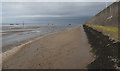
The Shoreline off Great Meols near Hoylake on the Wirral at SJ231906, once in Cheshire, but now in Merseyside. During the 19th century numerous artefacts from the Mesolithic to the medieval period were unearthed from a submerged forest on the seashore near Dove Point by the local residents of Hoylake. The discovery of several Roman coins (of Iron Age date) from Brittany and Armenia have led to speculation that Meols was an Iron Age trading port, perhaps used to export Cheshire salt to the Mediterranean.
You may be viewing yesterday's version of this page. To see the most up to date information please register for a free account.
Do not use the above information on other web sites or publications without permission of the contributor.
Nearby Images from Geograph Britain and Ireland:
©2017(licence)

©2005(licence)

©2017(licence)

©2014(licence)

©2014(licence)
The above images may not be of the site on this page, they are loaded from Geograph.
Please Submit an Image of this site or go out and take one for us!
Click here to see more info for this site
Nearby sites
Key: Red: member's photo, Blue: 3rd party photo, Yellow: other image, Green: no photo - please go there and take one, Grey: site destroyed
Download sites to:
KML (Google Earth)
GPX (GPS waypoints)
CSV (Garmin/Navman)
CSV (Excel)
To unlock full downloads you need to sign up as a Contributory Member. Otherwise downloads are limited to 50 sites.
Turn off the page maps and other distractions
Nearby sites listing. In the following links * = Image available
3.5km SW 231° Red Rocks* Ancient Mine, Quarry or other Industry (SJ20328843)
3.7km ESE 118° Overchurch* Stone Circle (SJ264888)
3.9km SSW 193° West Kirby Cremation Burial Cist (SJ22158678)
4.1km S 191° The Column* Chambered Tomb (SJ22248662)
4.4km SSW 196° St Bridget (West Kirby)* Early Christian Sculptured Stone (SJ21828641)
4.8km SE 145° Greasby Copse Ancient Village or Settlement (SJ25788664)
5.2km S 179° Face Stone (Stapledon Wood)* Rock Outcrop (SJ23088536)
5.3km WSW 239° Hilbre Island (Wirral Peninsula) Ancient Cross (SJ185879)
5.7km E 95° Bidston Hill Rock Carvings* Carving (SJ288900)
5.8km SSE 165° Thor's Stone* Natural Stone / Erratic / Other Natural Feature (SJ2447484933)
6.1km SE 139° Arrowe Park standing stones Standing Stones (SJ27058596)
7.3km E 101° The Bonks Barrow Cemetery (SJ303891)
10.5km SE 127° Red Hill Mound Artificial Mound (SJ31458412)
11.7km E 88° World Museum Liverpool* Museum (SJ348908)
12.0km ESE 121° Meyer Park Stone Circle* Modern Stone Circle etc
13.4km ENE 71° St Mary (Walton on the Hill) Ancient Cross (SJ35889482)
13.7km ESE 123° St Patrick's Well (Bromborough)* Holy Well or Sacred Spring (SJ34538295)
14.2km ENE 74° Modern stone circle on Cherry Avenue* Modern Stone Circle etc (SJ3687894265)
14.4km SSW 205° Ffynnon Oswald Holy Well or Sacred Spring (SJ1688577622)
14.4km SSE 154° St Mary and St Helen (Neston)* Ancient Cross (SJ29157749)
14.5km SE 125° St Barnabas (Bromborough)* Ancient Cross (SJ3491082212)
14.6km S 184° Bagillt 'Stonehenge' Modern Stone Circle etc (SJ21807605)
14.9km SE 141° Raby Mound Round Barrow(s) (SJ32377891)
15.0km SSW 213° Whitford Church Inscribed Stone Early Christian Sculptured Stone (SJ146782)
15.0km SSW 197° St Winefrides Well* Holy Well or Sacred Spring (SJ18517627)
View more nearby sites and additional images


 We would like to know more about this location. Please feel free to add a brief description and any relevant information in your own language.
 Wir möchten mehr über diese Stätte erfahren. Bitte zögern Sie nicht, eine kurze Beschreibung und relevante Informationen in Deutsch hinzuzufügen.
 Nous aimerions en savoir encore un peu sur les lieux. S'il vous plaît n'hesitez pas à ajouter une courte description et tous les renseignements pertinents dans votre propre langue.
 Quisieramos informarnos un poco más de las lugares. No dude en añadir una breve descripción y otros datos relevantes en su propio idioma.