Contributory members are able to log private notes and comments about each site
Sites theCaptain has logged. View this log as a table or view the most recent logs from everyone
Kerguntuil allée couverte
Trip No.203 Entry No.558 Date Added: 3rd Jun 2020
Site Type: Passage Grave
Country: France (Bretagne:Côtes-D'Armor (22))
Visited: Yes on 24th Jun 2005. My rating: Condition 4 Ambience 4 Access 4

Kerguntuil allée couverte submitted by greywether on 26th Jun 2005. Allee couverte from the NE. The entrance is on the right.
(View photo, vote or add a comment)
Log Text: Just about 100 metres upslope from the Kergunteuil dolmen can be found its neighbouring allée couverte, also signposted and kept in a little area. This one again has been incorporated into a field wall at some time in the past, which has no doubt ensured its survival.
It is 8 metres in length, oriented at 070° and has 4 capstones covering the 1.5 metre wide, 1 metre high chamber. The entrance is at the northwest end in the side, but I am not sure if this is the original. Inside the chamber are a few stones with engravings on them, one being particularly spectacular in the middle of the northern side. On it is a row of 6 pairs of outstanding spheres, most of which have a U shape carved beneath them, and which are interpreted as pairs of breasts. There is also another pair higher up. Several "palette" shapes are also carved, and several other symbols. The stone adjacent has a sort of crescent on it. A boat perhaps ? This is an excellent place to visit.
St Samson Chapel well
Trip No.203 Entry No.560 Date Added: 3rd Jun 2020
Site Type: Holy Well or Sacred Spring
Country: France (Bretagne:Côtes-D'Armor (22))
Visited: Yes on 24th Jun 2005. My rating: Condition 4 Ambience 4 Access 5
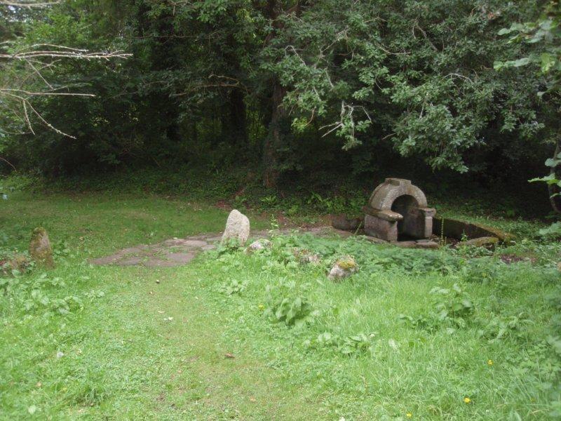
St Samson Chapel well submitted by Ural on 26th Dec 2012. Site in Bretagne:Côtes-D'Armor (22) France
(View photo, vote or add a comment)
Log Text: Just to the north of the St Samson chapel is a splendid little spring and well house, with clear water bubbling up from within it.
Crec'h Quillé
Trip No.203 Entry No.569 Date Added: 3rd Jun 2020
Site Type: Passage Grave
Country: France (Bretagne:Côtes-D'Armor (22))
Visited: Yes on 24th Jun 2005. My rating: Condition 4 Ambience 3 Access 4
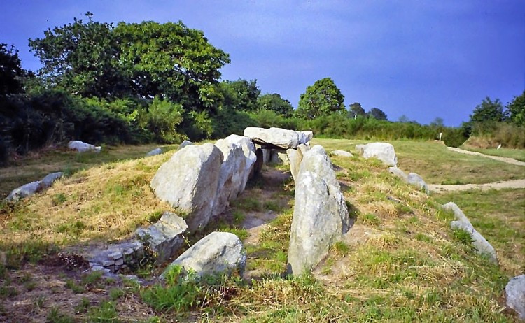
Crec'h Quillé submitted by greywether on 26th Jun 2005. A well-preserved allee-couverte with entrance, E/W chamber and mound. Art on one of the chamber stones opposite the entrance.
Photo looking E, taken June 1994.
(View photo, vote or add a comment)
Log Text: This allée couverte to the south of Perros Guirec is situated just to the east of the busy D.788 dual carriageway, and signposted from it, but most people will go whizzing straight past. From the parking area beside the main road, it is just a couple of hundred metres, but is walking access only. It's set in a nice little plot, probably originally intended for a house when it was discovered in about 1960.
It is surprisingly complete except for the capstones, and still has most of its surrounding mound and outer peristalith of alternating slabs and drystone walling. This is a rarity in these parts, a lateral entry allée couverte, with the main chamber running east west at 073°, and the entrance about two thirds the way along on the southern side.
The chamber is about 15 metres in length, by 1.7 metres width, but its surrounding mound is much larger. Just inside the main chamber, opposite to the entrance, is a smoothed and carved slab, which on one face, facing into the chamber, contains a pair of "breasts" with a large collar or crossed arms underneath. The adjacent face, which faces towards the smaller end of the monument, appears to have a "crosse" shape engraved on it. At this point are two capstones, which no doubt helped to preserve the engravings here. There is the base of a large stone just outside the entry, which is thought to be the base of an indicator menhir. The tumulus has been dated to about 2500BC.
I was going to drive past this myself in a rush to get somewhere else, but I am very glad I did stop to see it, and my visit lasted over an hour, which means I will be late to camp again tonight. A very nice monument.
Trémarche menhir
Trip No.203 Entry No.559 Date Added: 3rd Jun 2020
Site Type: Standing Stone (Menhir)
Country: France (Bretagne:Côtes-D'Armor (22))
Visited: Yes on 24th Jun 2005. My rating: Condition 3 Ambience 3 Access 5
Trémarche menhir submitted by thecaptain on 27th Feb 2007. 3 m tall menhir set into a little gravel area at the side of the D.11 road beside the junction at Trémarche, a few kilometres to the south of Trégastel.
(View photo, vote or add a comment)
Log Text: Pleasant enough menhir set into a little gravel area at the side of the D.11 road beside the junction at Trémarche a few kilometres to the south of Trégastel. It's about 3 metres high, of rectangular section, and made from a nice pink granite.
Keryvon allée couverte
Trip No.203 Entry No.556 Date Added: 3rd Jun 2020
Site Type: Passage Grave
Country: France (Bretagne:Côtes-D'Armor (22))
Visited: Yes on 24th Jun 2005. My rating: Condition 3 Ambience 3 Access 5
Keryvon allée couverte submitted by thecaptain on 27th Feb 2007. Right beside the D.788 road from Trébeurden to Trégastel, is the remains of what initially looks like a dolmen, but is part of what was once an allée couverte.
It has a single capstone on side supports only, but there are at least three of them on the south side, and possibly more.
(View photo, vote or add a comment)
Log Text: Right beside the D.788 road from Trébeurden to Trégastel, and only feet from the cliff edge is the remains of this dolmen, but it would not surprise me if it is part of what was once an allée couverte. It has a single capstone on side supports only, but there are at least three of them on the south side, and possibly more.
Survival of this has again been helped by it being part of a wall, but I suspect the road has cut off the eastern end. Orientation is 094°. Further into the hedge, and I think that there are a few peristalith stones also.
Toenno menhir
Trip No.203 Entry No.565 Date Added: 3rd Jun 2020
Site Type: Standing Stone (Menhir)
Country: France (Bretagne:Côtes-D'Armor (22))
Visited: Yes on 24th Jun 2005. My rating: Condition 3 Ambience 3 Access 4
Toenno menhir submitted by thecaptain on 10th Mar 2007. This little menhir now gets a drink most days at high tide, as it is situated in the marshes at the edge of the sea, and a high tide surrounds it.
(View photo, vote or add a comment)
Log Text: This little menhir now gets a drink most days at high tide, as it is situated in the marshes at the edge of the sea, and a high tide surrounds it. The menhir is less than 2 metres tall, but it is pleasantly shaped. It can be reached easily from a nearby track and carpark.
Dolmen de Lann Kerellec
Trip No.203 Entry No.564 Date Added: 3rd Jun 2020
Site Type: Passage Grave
Country: France (Bretagne:Côtes-D'Armor (22))
Visited: Yes on 24th Jun 2005. My rating: Condition 3 Ambience 2 Access 4
Dolmen de Lann Kerellec submitted by thecaptain on 11th Mar 2007. The remains of this allée couverte are situated in somebody's garden in the northern part of Trébeurden along the hilltop coast road, but it can be seen through the fence and over the wall from the roadside.
(View photo, vote or add a comment)
Log Text: This dolmen is situated in somebody's garden, but it can be seen through the fence and over the wall from the roadside. It is probably the remains of an allée couverte.
Parc-ar-Peulvennic
Trip No.203 Entry No.566 Date Added: 3rd Jun 2020
Site Type: Standing Stone (Menhir)
Country: France (Bretagne:Côtes-D'Armor (22))
Visited: Yes on 24th Jun 2005. My rating: Condition 3 Ambience 3 Access 3
Parc-ar-Peulvennic submitted by thecaptain on 12th Mar 2007. The Parc-ar-Peulvennic, or Run-ar-Cam menhir is just over 2 metres tall, and has been incorporated into a wall, but it is a splendid stone to go and see.
(View photo, vote or add a comment)
Log Text: This menhir can be reached only by getting wet feet at a very high tide, as it is right on the edge of the land in the marsh area near to Ile Grande. The stone is just over 2 metres tall, and has been incorporated into a wall, but it is a splendid stone to go and see. It is now incorporated into a local "Megalithic Trail", details of which can be obtained from the local tourist office.
Ty-Lia (Ile Renote)
Trip No.203 Entry No.568 Date Added: 3rd Jun 2020
Site Type: Passage Grave
Country: France (Bretagne:Côtes-D'Armor (22))
Visited: Yes on 24th Jun 2005. My rating: Condition 2 Ambience 3 Access 2
Ty-Lia (Ile Renote) submitted by thecaptain on 14th Mar 2007. This allée couverte is now a bit of a garden feature within the grounds of a large house on the island of Ile Renote, and is not on public property.
(View photo, vote or add a comment)
Log Text: This allée couverte is now a bit of a garden feature within the grounds of a large house on the island of Ile Renote, and is not on public property. Made from the lovely pink granite that everything is round here, the remains are about 8 metres in length and have only one capstone still in place, with another one fallen.
Closer investigation suggests that there may be remains of a lateral entry and peristalith but its difficult to tell. This place is surrounded by magnificent rocks and coastline, and a walk around this island is thoroughly recommended to everybody.
Trois-Tables-en-Place
Trip No.203 Entry No.563 Date Added: 3rd Jun 2020
Site Type: Passage Grave
Country: France (Bretagne:Côtes-D'Armor (22))
Visited: Yes on 24th Jun 2005. My rating: Condition 4 Ambience 5 Access 2
Trois-Tables-en-Place submitted by theCaptain on 26th Jun 2012. What a lovely situation this is in, out in the sea amongst all these rocks and islets. The island itself is now a nature reserve. This is a smashing place, and well worth the effort of a visit.
(View photo, vote or add a comment)
Log Text: The Trois-Tables-en-Place is a bit of a monster allée couverte, on the little island of Ile-Milliau which is reachable by foot only an hour or so each side of low tide. It is situated on a low flat spot just behind the farm buildings, in pretty much the middle of the island.
It has three capstones still on top of the upright supports, hence it's name, and there is at least another one fallen at the eastern end. It is about 14 metres long by 2 metres wide, and more than 2 metres high, with more than enough room to comfortably stand up inside.
What a lovely situation this is in, out in the sea amongst all these rocks and islets. The island itself is now a nature reserve and the previous buildings are uninhabited. This is a smashing place, and well worth the effort of a visit. There are rabbits hopping around everywhere, but a pity it has started to rain.
Mougau Bihan
Trip No.203 Entry No.542 Date Added: 2nd Jun 2020
Site Type: Passage Grave
Country: France (Bretagne:Finistère (29))
Visited: Yes on 23rd Jun 2005. My rating: Condition 5 Ambience 4 Access 5
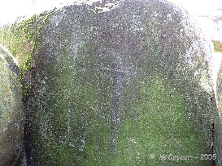
Mougau Bihan submitted by TheCaptain on 1st Dec 2007. The closing stone between the two chambers has a palette and also a wonderful polished axe, contained within its "crosse".
This is one of the least clear engravings, being much more weatherworn than some which have been better protected.
(View photo, vote or add a comment)
Log Text: This is an absolutely splendid allée couverte, which has been dated to 3000BC, found a couple of kilometres to the south of the village of Commana, and signposted from there. It has a little car park and picnic area, as well as a nice and spacious grassy area around it.
The main chamber is 14 metres in length and oriented approximately north to south, with its entrance at the northern end. The southern end has an extra small chamber, the "cella", the two parts being divided by a splendid "chevet" stone. The roof is made of five large capstones, four on the main chamber, and one on the cella. The internal width and height are about 1.5 metres.
But the best thing about this monument is all the ornamental engravings on the internal faces of the stones. About half of the side slabs have engravings on them which are fairly clear to make out. Most of these engravings are what are called "palettes", some stones having several of these of various designs next to each other. One of the stones has two pairs of the double hemispheres on it - these have been largely interpreted as pairs of breasts. The closing stone between the two chambers has a palette and also a wonderful polished axe, contained within its "crosse", but this is one of the least clear engravings, being much more weatherworn than some which have been better protected.
Mougau Bihan translates from the Breton language to "Fairies Cave".
Le Rocher du Diable
Trip No.203 Entry No.543 Date Added: 2nd Jun 2020
Site Type: Standing Stone (Menhir)
Country: France (Bretagne:Finistère (29))
Visited: Yes on 23rd Jun 2005. My rating: Condition 3 Ambience 3 Access 4
Le Rocher du Diable submitted by TheCaptain on 18th Apr 2011. This is a pleasant enough menhir in a field beside the road on the western slopes of the hill upon which the Chapelle St Michel is built. It's approaching three metres in height, nearly as wide at the base, and made of the local quarzite stone, which is pointed at the top.
(View photo, vote or add a comment)
Log Text: This is a pleasant enough menhir in a field beside the road on the western slopes of the hill upon which the Chapelle St Michel is built. It's approaching three metres in height, nearly as wide at the base, and made of the local quarzite stone, which is pointed at the top. There is another block of stone beside it which is the top which was broken off after a lightning strike. With a name like this, there should be legends and stories, but I dont know of any.
Bois de la Roche dolmen
Trip No.203 Entry No.541 Date Added: 2nd Jun 2020
Site Type: Burial Chamber or Dolmen
Country: France (Bretagne:Finistère (29))
Visited: Yes on 23rd Jun 2005. My rating: Condition 2 Ambience 3 Access 4
Bois de la Roche dolmen submitted by TheCaptain on 19th Apr 2011. I am not quite sure exactly what I found here - the pile of rocks I found looked decidedly natural, yet in a very distinctive pile.
Site in Bretagne: Finistère (29) France
(View photo, vote or add a comment)
Log Text: I am not quite sure exactly what I found here - the pile of rocks I found looked decidedly natural, yet in a very distinctive pile with one set on top of three and a large space underneath, and its in exactly the right place compared to the map. I guess its one of those dolmens made using the best locally available materials. In dense woodland, but right at the junction of two country lanes about 3 km north of the village of Commana.
Commana Stèle
Trip No.203 Entry No.540 Date Added: 2nd Jun 2020
Site Type: Standing Stone (Menhir)
Country: France (Bretagne:Finistère (29))
Visited: Yes on 23rd Jun 2005. My rating: Condition 3 Ambience 3 Access 5
Commana Stèle submitted by TheCaptain on 19th Apr 2011. In Commana, on the village green round the back of the church can be found this Iron Age granite stèle.
It is a tapered cylindrical shape just over 2 metres high, and has been christianised by the addition of a cross on the top.
(View photo, vote or add a comment)
Log Text: On the village green by the car park round the back of the church can be found this Iron Age granite stèle. It's a tapered cylindrical shape just over 2 metres high. There are no obvious grooves or other shaping to it.
An-Eured-Ven
Trip No.203 Entry No.544 Date Added: 2nd Jun 2020
Site Type: Stone Row / Alignment
Country: France (Bretagne:Finistère (29))
Visited: Yes on 23rd Jun 2005. My rating: Condition 3 Ambience 4 Access 4
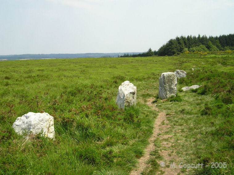
An-Eured-Ven submitted by thecaptain on 13th May 2008. a couple of hundred metre long, slightly curved line of white quartz blocks running along the ridgetop just to the south of the lake.
(View photo, vote or add a comment)
Log Text: On the high moorland to the southwest of the St Michel reservoir, in the bowl below the Montagnes d'Arrée to the southeast of Mont St Michel, can be found some rows of white quartz stones, the name of which, An-Eured-Ven, translates to something approximating the wedding stones dance.
I found a couple of hundred metre long, slightly curved line of white quartz blocks running along the ridgetop just to the south of the lake, the alignment of which varies from 078° to 085° as you go from west to east. Further thoughts on what I found, and I think its perhaps more like two straight rows which converge on a point, or a kinked row, rather than curved. At the kink there is a collection of larger stones which may at one point have been significant. At the eastern end the stones are bigger, and the last stone I found is positioned across the end of the row rather like a Dartmoor blocking stone. The row does not align on St Michel Hill, nor at this eastern end go along the top of the ridge as it runs away at 279°. The western end of the row just seems to fade away into the undergrowth.
Further looking around and I found another line of stones about 100 metres to the north, and which looks to be on an approximately parallel course to the first row. There are lots of other blocks of stone to be seen in amongst the heather, I wonder if a full survey has ever been done here ?
From on top of St Michel Hill, using binoculars, the two rows of stones can clearly be seen, but they form a sort of V shape, with the point towards the east. There is a group of schoolchildren out amongst the rows, with musicians and storytellers. What a great lesson they must be having.
Chapelle-des-Sept-Saints
Trip No.203 Entry No.552 Date Added: 2nd Jun 2020
Site Type: Burial Chamber or Dolmen
Country: France (Bretagne:Côtes-D'Armor (22))
Visited: Yes on 23rd Jun 2005

Chapelle-des-Sept-Saints submitted by thecaptain on 5th Jul 2005. Chapelle-des-Sept-Saints, not too far from Lannion in Brittany.
The chapel is built right on top of a dolmen, which makes up the southern crypt, which can be seen through the square entrance, slightly below ground level.
(View photo, vote or add a comment)
Log Text: I had terrible trouble finding this from the south. The road signs are almost non existent, and very inconsistent, and its all windy lanes and farm tracks. None of the roads, or the names on any of the rare signs seem to agree with the maps. I think the maps are in French, while the signs are in Breton ! I eventually found it by a bit of a fluke, after travelling for a fair distance along a road I was wanting to turn round on, and go back, there it was, right in front of me. That said, when I left, and went northwards, it couldn’t be much problem to find it coming from the north, it seems like one road to get there, and its signposted from the main road.
By the time I got here, it was 7:00 pm, and it was all closed up. However, there was a little sign outside telling you about the place in four languages, one of which was English. The Chapel is built right on top of a dolmen, (Stivel dolmen), and the southern Crypt is within the dolmen itself. The dolmen is a big one, and a registered historic monument, being about 4 metres by 2 metres, made with 4 sidestones and 2 capstones. From the outside, there is a little gated doorway, through which you can see partly into the inside, and the dolmen is plain to see. It has been adapted somewhat for its new role, and I think that there are little statues of the seven saints contained in alcoves within the dolmen.
Now this is one way of Christianising an ancient site !!! although it must be said that the chapel is a place of pilgrimage for Moslems. So, there’s at least three beliefs all coming together at the same place.
Leintant menhir
Trip No.203 Entry No.546 Date Added: 2nd Jun 2020
Site Type: Standing Stone (Menhir)
Country: France (Bretagne:Finistère (29))
Visited: Couldn't find on 23rd Jun 2005
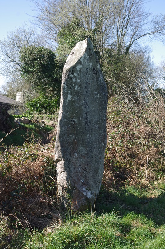
Leintant menhir submitted by wiltswarrior on 5th Apr 2015. Site in Bretagne:Finistère (29) France
(View photo, vote or add a comment)
Log Text: Three metre tall menhir, which was probably once part of the nearby alignment.
Alignement de Leintant
Trip No.203 Entry No.547 Date Added: 2nd Jun 2020
Site Type: Stone Row / Alignment
Country: France (Bretagne:Finistère (29))
Visited: Couldn't find on 23rd Jun 2005
Log Text: Row of fallen menhirs now incorporated into a bank at the edge of a field. I could find no trace of this alignment, supposed to contain one standing and three fallen menhirs, which was said to align on mid-summer sunrise. I found the farm, and went up and down the road several times, with no luck. Supposedly, the standing stone is nearly 4 metres tall and beside the road.....
Menhir de Coat Mocun nord
Trip No.203 Entry No.550 Date Added: 2nd Jun 2020
Site Type: Standing Stone (Menhir)
Country: France (Bretagne:Finistère (29))
Visited: Couldn't find on 23rd Jun 2005
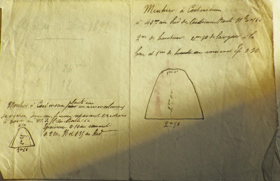
Menhir de Coat Mocun submitted by Liamean on 27th Jul 2016. Menhir de Coat Mocun.
(View photo, vote or add a comment)
Log Text: Supposedly 8 metres tall, and re-erected recently when they built the new road, I could not find this. I asked an old gent with a straw hat and waving a stick, who was pushing a wheelbarrow of grass. He took great delight in telling me how I could get to see it, although it was on private land, but he was fairly difficult to understand. From what I did understand, I thought he said it was in a quarry area, I had several looks, from various points of attack, but could not find it. Bummer.
Ty-Lia (Île Grande)
Trip No.203 Entry No.553 Date Added: 2nd Jun 2020
Site Type: Passage Grave
Country: France (Bretagne:Côtes-D'Armor (22))
Visited: Yes on 23rd Jun 2005. My rating: Condition 4 Ambience 3 Access 5

Ty-Lia (Ile Grande) submitted by greywether on 26th Jun 2005. Allee-couverte surrounded by stones marking the edge of the mound.
(View photo, vote or add a comment)
Log Text: This looks to be a fairly complete standard allée couverte well signposted and in a little grassy area on Ile-Grande, just off the coast near Trebeurden. It is about 9 metres long by 1.5 metres wide, and oriented to 110°. There are two large capstones which cover most of the chamber. Many of the outer peristalith stones survive, particularly on the southern side and the back end, and there are traces of the mound within them.
