

<< Our Photo Pages >> An-Eured-Ven - Stone Row / Alignment in France in Bretagne:Finistère (29)
Submitted by TheCaptain on Tuesday, 13 May 2008 Page Views: 7479
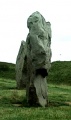
Neolithic and Bronze AgeSite Name: An-Eured-Ven Alternative Name: La Noce de Pierre, Marriage de Pierres, Alignement de An Eured VeignCountry: France Département: Bretagne:Finistère (29) Type: Stone Row / Alignment
Nearest Town: Carhaix-Plouger Nearest Village: Brasparts
Latitude: 48.346000N Longitude: 3.9321W
Condition:
| 5 | Perfect |
| 4 | Almost Perfect |
| 3 | Reasonable but with some damage |
| 2 | Ruined but still recognisable as an ancient site |
| 1 | Pretty much destroyed, possibly visible as crop marks |
| 0 | No data. |
| -1 | Completely destroyed |
| 5 | Superb |
| 4 | Good |
| 3 | Ordinary |
| 2 | Not Good |
| 1 | Awful |
| 0 | No data. |
| 5 | Can be driven to, probably with disabled access |
| 4 | Short walk on a footpath |
| 3 | Requiring a bit more of a walk |
| 2 | A long walk |
| 1 | In the middle of nowhere, a nightmare to find |
| 0 | No data. |
| 5 | co-ordinates taken by GPS or official recorded co-ordinates |
| 4 | co-ordinates scaled from a detailed map |
| 3 | co-ordinates scaled from a bad map |
| 2 | co-ordinates of the nearest village |
| 1 | co-ordinates of the nearest town |
| 0 | no data |
Internal Links:
External Links:
I have visited· I would like to visit
TheCaptain visited on 23rd Jun 2005 - their rating: Cond: 3 Amb: 4 Access: 4 On the high moorland to the southwest of the St Michel reservoir, in the bowl below the Montagnes d'Arrée to the southeast of Mont St Michel, can be found some rows of white quartz stones, the name of which, An-Eured-Ven, translates to something approximating the wedding stones dance.
I found a couple of hundred metre long, slightly curved line of white quartz blocks running along the ridgetop just to the south of the lake, the alignment of which varies from 078° to 085° as you go from west to east. Further thoughts on what I found, and I think its perhaps more like two straight rows which converge on a point, or a kinked row, rather than curved. At the kink there is a collection of larger stones which may at one point have been significant. At the eastern end the stones are bigger, and the last stone I found is positioned across the end of the row rather like a Dartmoor blocking stone. The row does not align on St Michel Hill, nor at this eastern end go along the top of the ridge as it runs away at 279°. The western end of the row just seems to fade away into the undergrowth.
Further looking around and I found another line of stones about 100 metres to the north, and which looks to be on an approximately parallel course to the first row. There are lots of other blocks of stone to be seen in amongst the heather, I wonder if a full survey has ever been done here ?
From on top of St Michel Hill, using binoculars, the two rows of stones can clearly be seen, but they form a sort of V shape, with the point towards the east. There is a group of schoolchildren out amongst the rows, with musicians and storytellers. What a great lesson they must be having.
")
I found a couple of hundred metre long, slightly curved line of white quartz blocks running along the ridgetop just to the south of the lake, the alignment of which varies from 078° to 085° as you go from west to east.
Later thoughts on what I found, and I think it's perhaps more like two straight rows which converge on a point, or a kinked row, rather than curved. At the kink there is a collection of larger stones which may at one point have been significant. At the eastern end the stones are bigger, and the last stone I found is positioned across the end of the row rather like a Dartmoor blocking stone.
The row does not align on St Michel Hill, nor at this eastern end go along the top of the ridge as it runs away at 279°. The western end of the row just seems to fade away into the undergrowth.
Further looking around and I found another possible line of stones about 100 metres to the north, and which looks to be on an approximately parallel course to the first row.
There are lots of other blocks of stone to be seen in amongst the heather, I wonder if a full survey has ever been done here ? From on top of St Michel Hill, using binoculars, the two rows of stones can clearly be seen, but they seem to form a sort of V shape, with the point towards the east.
You may be viewing yesterday's version of this page. To see the most up to date information please register for a free account.
")
")
")
")
")
")
")
")
Do not use the above information on other web sites or publications without permission of the contributor.
Click here to see more info for this site
Nearby sites
Click here to view sites on an interactive map of the areaKey: Red: member's photo, Blue: 3rd party photo, Yellow: other image, Green: no photo - please go there and take one, Grey: site destroyed
Download sites to:
KML (Google Earth)
GPX (GPS waypoints)
CSV (Garmin/Navman)
CSV (Excel)
To unlock full downloads you need to sign up as a Contributory Member. Otherwise downloads are limited to 50 sites.
Turn off the page maps and other distractions
Nearby sites listing. In the following links * = Image available
2.6km ESE 104° Roc'h Cléguer menhir* Standing Stone (Menhir)
2.8km WNW 291° Le Rocher du Diable* Standing Stone (Menhir)
6.3km ENE 78° Brennilis Menhirs* Standing Stones
6.5km ENE 74° Ty ar Boudiquet Dolmen* Burial Chamber or Dolmen
6.5km NNW 337° Mougau Bihan* Passage Grave
6.9km S 176° Cromlech du Moulin du Duc Stone Circle
7.2km E 79° Menhir de Kermorvan Standing Stone (Menhir)
7.7km ESE 108° Allée couverte de Be Keor Passage Grave
7.8km ENE 65° Tumulus de Kerelcan* Round Barrow(s)
7.8km N 7° Dolmen de Keradalan Burial Chamber or Dolmen
7.8km NNW 347° Commana Stèle* Standing Stone (Menhir)
8.4km ENE 66° Kerelcun Menhir* Standing Stone (Menhir)
8.9km E 83° Alignement de Leintant Stone Row / Alignment
8.9km E 84° Leintant menhir* Standing Stone (Menhir)
9.2km E 79° Dolmen de Coat Mocun Burial Chamber or Dolmen
9.4km NNW 339° Quillidiec menhir Standing Stone (Menhir)
9.4km NE 42° Menhir de Flagous Standing Stone (Menhir)
9.7km ENE 77° Coatmocun north menhir Standing Stone (Menhir)
9.7km N 351° Bois de la Roche dolmen* Burial Chamber or Dolmen
9.7km E 82° Dolmen de Plouénez Burial Chamber or Dolmen
9.7km E 79° Menhir de Coatmocun (Huelgoat)* Standing Stone (Menhir)
9.7km E 86° Menhir du Roz Perez* Standing Stone (Menhir)
9.8km E 81° Menhir de Coat Mocoun (sud)* Standing Stone (Menhir)
9.9km ENE 78° Menhir de Coatmocun * Standing Stone (Menhir)
10.0km N 349° Kerestan menhir Standing Stone (Menhir)
View more nearby sites and additional images


 We would like to know more about this location. Please feel free to add a brief description and any relevant information in your own language.
 Wir möchten mehr über diese Stätte erfahren. Bitte zögern Sie nicht, eine kurze Beschreibung und relevante Informationen in Deutsch hinzuzufügen.
 Nous aimerions en savoir encore un peu sur les lieux. S'il vous plaît n'hesitez pas à ajouter une courte description et tous les renseignements pertinents dans votre propre langue.
 Quisieramos informarnos un poco más de las lugares. No dude en añadir una breve descripción y otros datos relevantes en su propio idioma.