Contributory members are able to log private notes and comments about each site
Sites theCAptain has logged. View this log as a table or view the most recent logs from everyone
Kervengu Dolmen
Trip No.203 Entry No.343 Date Added: 10th May 2020
Site Type: Burial Chamber or Dolmen
Country: France (Bretagne:Morbihan (56))
Visited: Saw from a distance on 11th Jun 2005. My rating: Condition 3 Ambience 3
Kervengu dolmen submitted by thecaptain on 11th May 2006. This is a nice looking dolmen in the middle of a field of sweetcorn, with no obvious access to it.
(View photo, vote or add a comment)
Log Text: This is a nice looking dolmen in the middle of a field of sweetcorn, with no obvious access to it. From a distance, it looks like a single large capstone on top of three supports, but this is probably wrong. There is a tree growing beside it.
Île Longue tumulus
Trip No.203 Entry No.333 Date Added: 4th May 2020
Site Type: Chambered Tomb
Country: France (Bretagne:Morbihan (56))
Visited: Saw from a distance on 10th Jun 2005
Île Longue tumulus submitted by TheCaptain on 11th Jun 2020. Plan of the tumulus taken from "Il faut qu’une tombe soit ouverte ou fermée" by Charles-Tangay Le Roux
(View photo, vote or add a comment)
Log Text: I took a walk out to the Pointe de Penbert, from where the entrance to the Golfe de Morbihan can clearly be seen, and all the many islands within the gulf. It is a smashing day with a good breeze, and lots and lots of sailing boats are out having fun. There's a cracking tacking duel going on between two large single handed craft as I was writing. It all looks lots and lots of fun.
Just offshore can be seen the islet of Er Lannic, with its double cromlech. Many of the stones stand proud of the island, and indeed the sea, where these half submerged circles are situated, and can clearly be seen from here. Just beyond that is Gavrinis, with its large cairn and entrance overlooking the whole scene. The entrance seems to be looking directly towards me, although in reality it is probably looking a bit more towards the east. The cairn is clearly visible, looking pale against the dark background of a pinewood. A boat trip of people has just landed on the island for the guided visit to the cairn, with its magnificent carvings.
A bit further away to the west is Isle Longue, with its large tumulus at the south end of the island visible, and beyond that is Locmariaquer, with all its sites.
Gavrinis Cairn
Trip No.203 Entry No.332 Date Added: 4th May 2020
Site Type: Chambered Cairn
Country: France (Bretagne:Morbihan (56))
Visited: Saw from a distance on 10th Jun 2005
Gavrinis Cairn submitted by TheCaptain on 4th Aug 2010. The megalithic art display at the Bougon Museum culminates in a full size reconstruction of the Gavrinis internal chamber.
(View photo, vote or add a comment)
Log Text: I took a walk out to the Pointe de Penbert, from where the entrance to the Golfe de Morbihan can clearly be seen, and all the many islands within the gulf. It is a smashing day with a good breeze, and lots and lots of sailing boats are out having fun. There's a cracking tacking duel going on between two large single handed craft as I was writing. It all looks lots and lots of fun.
Just offshore can be seen the islet of Er Lannic, with its double cromlech. Many of the stones stand proud of the island, and indeed the sea, where these half submerged circles are situated, and can clearly be seen from here.
Just beyond that is Gavrinis, with its large cairn and entrance overlooking the whole scene. The entrance seems to be looking directly towards me, although in reality it is probably looking a bit more towards the east. The cairn is clearly visible, looking pale against the dark background of a pinewood. A boat trip of people has just landed on the island for the guided visit to the cairn, with its magnificent carvings.
Er Lannic
Trip No.203 Entry No.331 Date Added: 4th May 2020
Site Type: Stone Circle
Country: France (Bretagne:Morbihan (56))
Visited: Saw from a distance on 10th Jun 2005
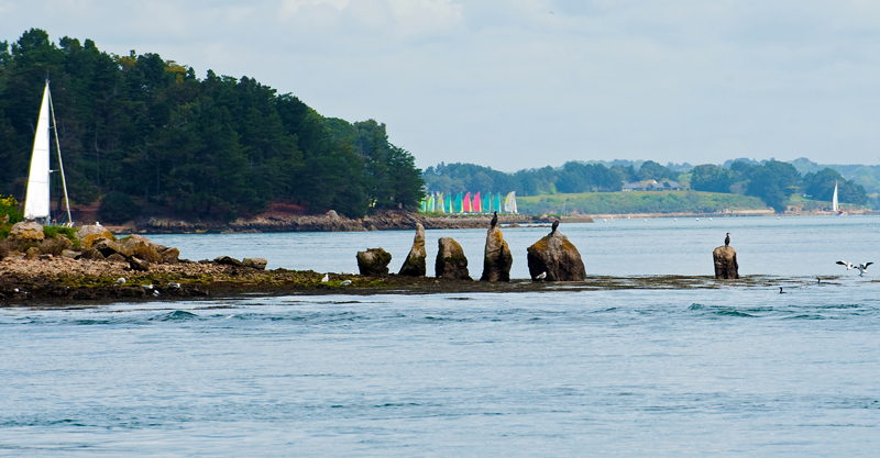
Er Lannic submitted by 43559959 on 15th May 2014. Er Lannic and it's birds.
(View photo, vote or add a comment)
Log Text: I took a walk out to the Pointe de Penbert, from where the entrance to the Golfe de Morbihan can clearly be seen, and all the many islands within the gulf. It is a smashing day with a good breeze, and lots and lots of sailing boats are out having fun. There's a cracking tacking duel going on between two large single handed craft as I was writing. It all looks lots and lots of fun. Just offshore can be seen the islet of Er Lannic, with its double cromlech. Many of the stones stand proud of the island, and indeed the sea, where these half submerged circles are situated, and can clearly be seen from here.
Revin Dolmen
Trip No.203 Entry No.319 Date Added: 29th Apr 2020
Site Type: Burial Chamber or Dolmen
Country: France (Pays de la Loire:Loire-Atlantique)
Visited: Saw from a distance on 9th Jun 2005
Revin dolmen submitted by Dipo on 12th Oct 2008. Revin dolmen
(View photo, vote or add a comment)
Log Text: I found nowhere to stop near here on the horribly busy road with everyone rushing home from work in St Nazaire. However, I don’t let it beat me that easily, and eventually found somewhere to stop and wallk back to where the dolmen is marked on the map. Once I got there, I could see no way into the field, but could see lots of stones in a heap on top of a mound.
Karlane Dolmen
Trip No.203 Entry No.316 Date Added: 29th Apr 2020
Site Type: Passage Grave
Country: France (Pays de la Loire:Loire-Atlantique)
Visited: Saw from a distance on 9th Jun 2005
Karlane Dolmen submitted by TheCaptain on 9th Jun 2011. A bit further down the lane from the first dolmen, a few stones which are probably remnants of the second dolmen could be seen on top of a little mound across a freshly ploughed field.
(View photo, vote or add a comment)
Log Text: Not far from Bergnon are two dolmens marked down a little lane. I walked down the lane but couldn’t really find anything, although I was assured by a passing chap on a bike, that it is possible to access both dolmens. But the barriers, crops and hedges here made it all too much effort for probably little gain, so I didn't try too hard. A bit further down the lane, a few stones which are probably remnants of the second dolmen could be seen on top of a little mound across a freshly ploughed field.
La Table Submergée
Trip No.203 Entry No.292 Date Added: 26th Apr 2020
Site Type: Burial Chamber or Dolmen
Country: France (Pays de la Loire:Vendée (85))
Visited: Saw from a distance on 8th Jun 2005
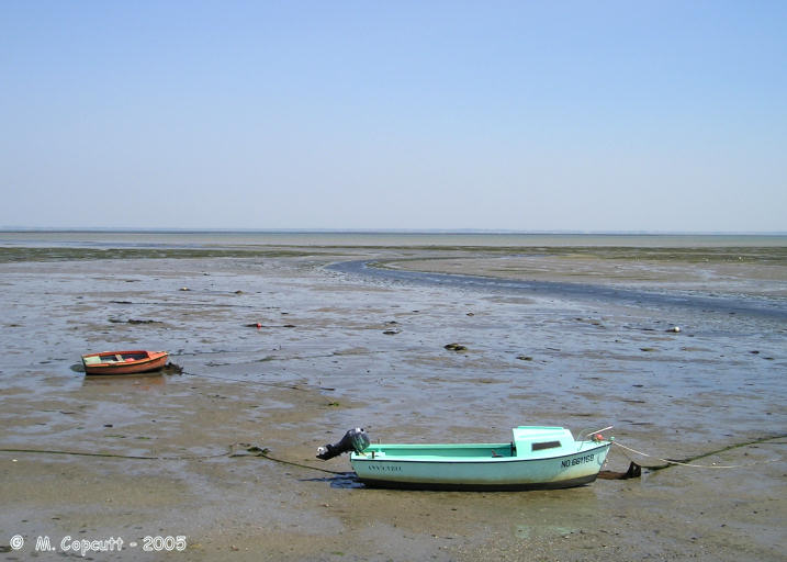
La Table Submergée submitted by thecaptain on 11th Dec 2005. Out in the sea and mudflats of the Baie de Bourgneuf, a kilometre or two off from the northeastern coast of Ile Noirmoutier, is a dolmen which can be seen at low tide, but which gets covered by the high tide.
I reckon I could see it through my binoculars from the island, there's a very table like rock out there, and nothing else like it to be seen nearby.
(View photo, vote or add a comment)
Log Text: Out in the sea and mudflats, a kilometre or two off from the northeastern coast of Ile Noirmoutier, is a dolmen which can be seen at low tide. I reckon I can see it through my binoculars, there's a very table like rock out there, and nothing else to be seen. There is a boat moored nearby, probably fishing.
La Garnerie menhir
Trip No.203 Entry No.276 Date Added: 24th Apr 2020
Site Type: Standing Stone (Menhir)
Country: France (Pays de la Loire:Vendée (85))
Visited: Saw from a distance on 6th Jun 2005. My rating: Condition 4 Access 2
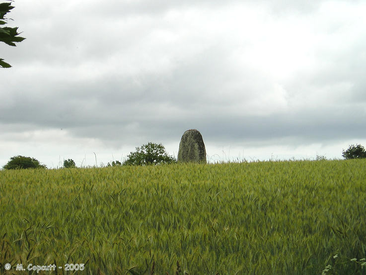
La Garnerie menhir submitted by thecaptain on 13th Dec 2005. La Garnerie menhir is a great big menhir in a field of barley, and there was no way I was going to get to it.
I would estimate it to be 4 to 5 metres tall and it is nicely rounded.
(View photo, vote or add a comment)
Log Text: This is a great big menhir in a field of barley, and there was no way I was going to get to it. I would estimate it to be 4 to 5 metres tall and it is nicely rounded. My gps position is to the field gate from where it can be seen.
La Motte a Poljeau
Trip No.203 Entry No.239 Date Added: 22nd Apr 2020
Site Type: Chambered Tomb
Country: France (Poitou:Charente (16))
Visited: Saw from a distance on 3rd Jun 2005
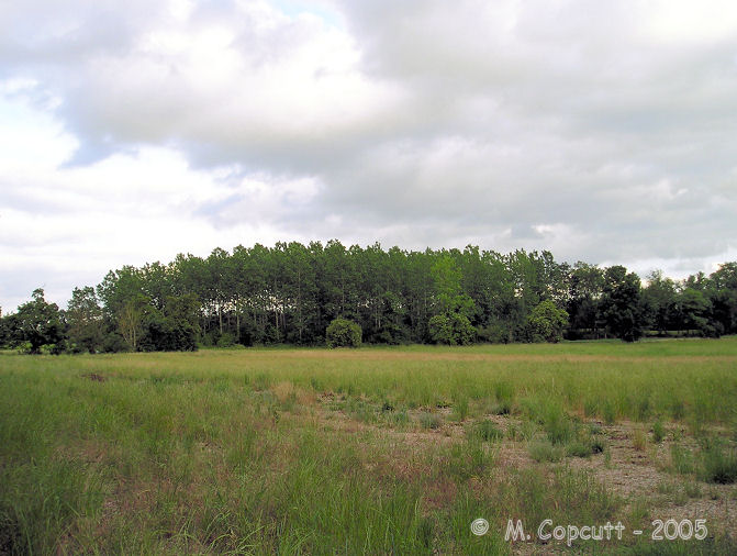
La Motte a Poljeau submitted by TheCaptain on 28th Jul 2007. To the north of the Couvoisier town of Jarnac, near the village of Métairies is marked a tumulus called La Motte a Poljeau.
(View photo, vote or add a comment)
Log Text: To the north of the Couvoisier town of Jarnac, near the village of Métairies is marked a tumulus. I thought I'd found a massive tumulus in about the right place in amongst some trees, but a closer inspection didn’t show there to be an obvious tumulus there. It was getting late, so i didnt look too much harder, as its time to stop for the day.
Roquefort Settlement
Trip No.203 Entry No.230 Date Added: 22nd Apr 2020
Site Type: Ancient Village or Settlement
Country: France (Aquitaine:Gironde (33))
Visited: Saw from a distance on 3rd Jun 2005
Log Text: Not far from the Chateau, on a wooded promontary in the river, are the remains of a bronze / iron age promontary fort and settlement.
Grotte de la Mouthe
Trip No.203 Entry No.218 Date Added: 21st Apr 2020
Site Type: Cave or Rock Shelter
Country: France (Aquitaine:Dordogne (24))
Visited: Saw from a distance on 2nd Jun 2005
Grotte de la Mouthe submitted by TheCaptain on 13th Jan 2011. Now closed to the public, this cave was discovered in 1895 and was pivotal in the argument for the decorations being of ancient origin.
(View photo, vote or add a comment)
Log Text: Now closed to the public this cave was discovered in 1895 and was pivotal in the argument for the decorations being of ancient origin. Apparently there are artworks from many different periods of the prehistoric past in here from the Gravettian through Mousterian to the Magdelenian. This cave is up a very windy rough track from Les Eyzies which I very nearly got stuck up due to a narrowing of the track on the way down the other side between a couple of farm buildings through which a camper van won’t fit. I just about managed to turn round using a farm lawn and got to go back down the way I had come up!
Puech de las Fadès
Trip No.203 Entry No.170 Date Added: 16th Apr 2020
Site Type: Hillfort
Country: France (Midi:Aveyron (12))
Visited: Saw from a distance on 26th May 2005
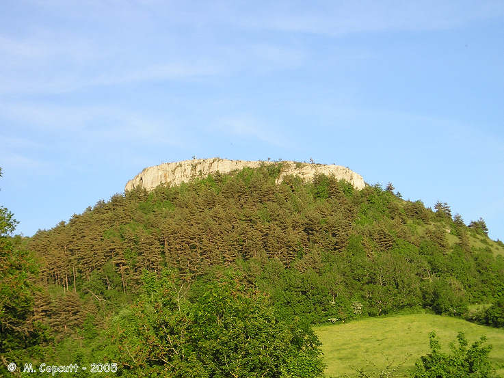
Puech de las Fadès submitted by thecaptain on 29th Nov 2005. Puech de las Fadès, or Hill of the Fairies in the local Occitain language.
(View photo, vote or add a comment)
Log Text: A significant hill of the region, which at the top has some significant cliff faces, making it an obvious place for a defended settlement in ancient times. Puech de las Fadès means Hill of the Fairies in the local Occitain language, and many stories and legends abound about the fairies who live on the hill, who are said to have built the nearby Buzareingues and Galitorte dolmens.
Mas de Greil Oppidum
Trip No.203 Entry No.147 Date Added: 15th Apr 2020
Site Type: Promontory Fort / Cliff Castle
Country: France (Midi:Lot (46))
Visited: Saw from a distance on 25th May 2005
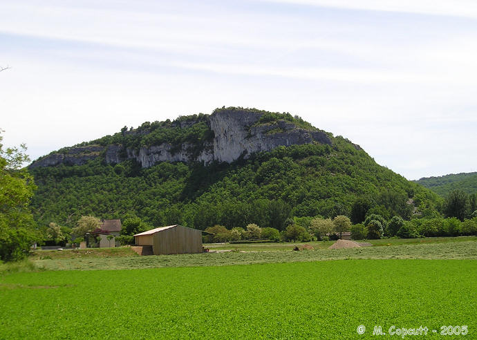
Mas de Greil Oppidum submitted by thecaptain on 21st Jan 2006. High on cliffs overlooking the Célé river, this hill has been inhabited and used as a hilltop refuge since 5000BC.
It doesn’t need much defending but there are 5 metre deep ditches across the neck of land attaching it to the high Causse.
(View photo, vote or add a comment)
Log Text: High on cliffs overlooking the Célé river this hill surrounded on 3 sides by high cliffs has been inhabited and used as a hilltop refuge since 5000BC. It doesn’t need much defending but there are 5 metre deep ditches across the neck of land attaching it to the high Causse.
Grotte des Merveilles
Trip No.203 Entry No.130 Date Added: 7th Apr 2020
Site Type: Cave or Rock Shelter
Country: France (Midi:Lot (46))
Visited: Saw from a distance on 23rd May 2005. My rating: Access 5
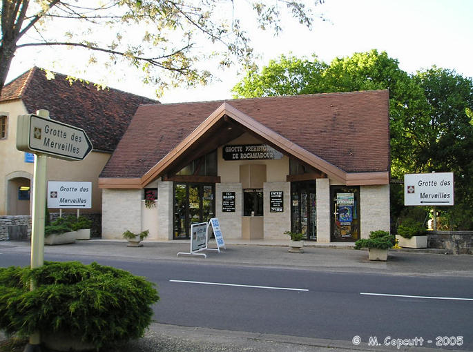
Grotte des Merveilles submitted by thecaptain on 5th Jan 2006. The entry building for visits to the Grotte des Merveilles in Rocamadour.
Does it have enough signs pointing to it ?
(View photo, vote or add a comment)
Log Text: Saw the entrance to this at least the ticket office and shop. Does it have enough signs pointing to it ?
Le Rigourdou
Trip No.203 Entry No.88 Date Added: 6th Apr 2020
Site Type: Cave or Rock Shelter
Country: France (Aquitaine:Dordogne (24))
Visited: Saw from a distance on 20th May 2005
Le Rigourdou submitted by TheCaptain on 14th Jan 2011. These days, this cliff shelter is contained within a little visitor centre with bears.
(View photo, vote or add a comment)
Log Text: Within this cliff shelter just a bit up the hillside from Lascaux found in March 1954 had the discovery made on 22 September 1957 of a complete Neanderthal skeleton in it. Not only this but also several burials of at least 5 bears were found suggesting some strange bear cult or activity. These days its fenced off with a little visitor centre and bears.
Abri de Laugerie-Haute
Trip No.203 Entry No.77 Date Added: 5th Apr 2020
Site Type: Cave or Rock Shelter
Country: France (Aquitaine:Dordogne (24))
Visited: Saw from a distance on 18th May 2005. My rating: Access 4
Abri de Laugerie-Haute submitted by TheCaptain on 9th Jan 2011. This was one of the biggest rock shelters anywhere and was inhabited since 50000 years ago.
Much of the cliff roof fell down about 10000 years ago and wrecked the place. This had the effect of burying all the archaeology hence preserving it to the present day and preventing it being rebuilt and reused in the millennia past or being plundered in the last few centuries.
(View photo, vote or add a comment)
Log Text: Just to the northwest of Les Eyzies on the west bank of the river Vézère is found the ancient cliff settlement of Laugerie Haute. This was one of the biggest rock shelters anywhere and was inhabited since 50000 years ago. But much of the cliff roof fell down about 10000 years ago and wrecked the place. This had the effect of burying all the archaeology hence preserving it to the present day and preventing it being rebuilt and reused in the millennia past or being plundered in the last few centuries.
Abri de Ruth
Trip No.203 Entry No.76 Date Added: 5th Apr 2020
Site Type: Cave or Rock Shelter
Country: France (Aquitaine:Dordogne (24))
Visited: Saw from a distance on 18th May 2005. My rating: Access 4
Abri de Ruth submitted by theCaptain on 6th Jan 2011. Just to the south of the village of Le Moustoir on the west bank of the Vézère is found this collection of caves and a museum of artefacts. Supposedly a very important place from where the stratigraphy of the various ancient eras was determined.
(View photo, vote or add a comment)
Log Text: Just to the south of the village of Le Moustoir on the west bank of the Vézère is found this collection of caves and a museum of artefacts. .Supposedly a very important place from where the stratigraphy of the various eras was determined. But getting on in the evening very tired after a long hilly bike ride when its shut it looks just like a cave in a cliff face in a garden to me !
Abri du Moustier
Trip No.203 Entry No.75 Date Added: 5th Apr 2020
Site Type: Cave or Rock Shelter
Country: France (Aquitaine:Dordogne (24))
Visited: Saw from a distance on 18th May 2005. My rating: Access 4
Abri du Moustier submitted by theCaptain on 6th Jan 2011. In the cliff face right opposite the main square in the delightful village of Le Moustoir on the west bank of the Vézère is found this World Heritage Site. Things found here gave its name to an entire epoch; the Mousterien.
(View photo, vote or add a comment)
Log Text: In the cliff face right opposite the main square in the delightful village of Le Moustoir on the west bank of the Vézère is found this World Heritage Site. Things found here gave its name to an entire epoch the Mousterien. But late on in the day on a long bike ride and wanting to get back (and knowing there's at least one more big hill in the way) it looked like more fenced and walled off bits of cliff face.
Gisement du Pataud
Trip No.203 Entry No.68 Date Added: 5th Apr 2020
Site Type: Cave or Rock Shelter
Country: France (Aquitaine:Dordogne (24))
Visited: Saw from a distance on 17th May 2005. My rating: Access 4
Gisement du Pataud submitted by theCaptain on 6th Jan 2011. There’s a museum built into the cliff face here and a covered area which looks like some sort of exhibition of an archaeological dig.
(View photo, vote or add a comment)
Log Text: There’s a museum built into the cliff face here and a covered area which looks like some sort of exhibition of an archaeological dig. Its between Cro Magnon and the Les Eyzies museum halfway up the cliff face.
Grotte de Grand Roc
Trip No.203 Entry No.67 Date Added: 5th Apr 2020
Site Type: Cave or Rock Shelter
Country: France (Aquitaine:Dordogne (24))
Visited: Saw from a distance on 17th May 2005. My rating: Access 4
Grotte de Grand Roc submitted by TheCaptain on 9th Jan 2011. In the same massive cliff face as Laugerie Basse, amongst the prehistoric shelters and modern day dwellings is to be found the Grotte de Grand Roc.
(View photo, vote or add a comment)
Log Text: Don’t know whether theres any prehistoric stuff in here but its supposed to have lots of natural wonders. In the same cliff face as Laugerie Basse.
