


<< Our Photo Pages >> Grotte de la Mouthe - Cave or Rock Shelter in France in Aquitaine:Dordogne (24)
Submitted by TheCaptain on Saturday, 16 April 2005 Page Views: 9839
Natural PlacesSite Name: Grotte de la MoutheCountry: France Département: Aquitaine:Dordogne (24) Type: Cave or Rock Shelter
Nearest Town: Sarlat-la-Canéda Nearest Village: Les Eyzies-de-Tayac
Latitude: 44.924733N Longitude: 1.020722E
Condition:
| 5 | Perfect |
| 4 | Almost Perfect |
| 3 | Reasonable but with some damage |
| 2 | Ruined but still recognisable as an ancient site |
| 1 | Pretty much destroyed, possibly visible as crop marks |
| 0 | No data. |
| -1 | Completely destroyed |
| 5 | Superb |
| 4 | Good |
| 3 | Ordinary |
| 2 | Not Good |
| 1 | Awful |
| 0 | No data. |
| 5 | Can be driven to, probably with disabled access |
| 4 | Short walk on a footpath |
| 3 | Requiring a bit more of a walk |
| 2 | A long walk |
| 1 | In the middle of nowhere, a nightmare to find |
| 0 | No data. |
| 5 | co-ordinates taken by GPS or official recorded co-ordinates |
| 4 | co-ordinates scaled from a detailed map |
| 3 | co-ordinates scaled from a bad map |
| 2 | co-ordinates of the nearest village |
| 1 | co-ordinates of the nearest town |
| 0 | no data |
Be the first person to rate this site - see the 'Contribute!' box in the right hand menu.
Internal Links:
External Links:
I have visited· I would like to visit
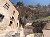
TheCaptain saw from a distance on 2nd Jun 2005 Now closed to the public this cave was discovered in 1895 and was pivotal in the argument for the decorations being of ancient origin. Apparently there are artworks from many different periods of the prehistoric past in here from the Gravettian through Mousterian to the Magdelenian. This cave is up a very windy rough track from Les Eyzies which I very nearly got stuck up due to a narrowing of the track on the way down the other side between a couple of farm buildings through which a camper van won’t fit. I just about managed to turn round using a farm lawn and got to go back down the way I had come up!
")
This cave is up a very windy rough track from Les Eyzies where I very nearly got stuck at, due to a narrowing of the track on the way down the other side between a couple of farm buildings through which a camper van won’t fit. I just about managed to turn round using a farm lawn and got to go back down the way I had come up!
You may be viewing yesterday's version of this page. To see the most up to date information please register for a free account.
")
")
")
")
Do not use the above information on other web sites or publications without permission of the contributor.
Nearby Images from Flickr

The above images may not be of the site on this page, but were taken nearby. They are loaded from Flickr so please click on them for image credits.
Click here to see more info for this site
Nearby sites
Click here to view sites on an interactive map of the areaKey: Red: member's photo, Blue: 3rd party photo, Yellow: other image, Green: no photo - please go there and take one, Grey: site destroyed
Download sites to:
KML (Google Earth)
GPX (GPS waypoints)
CSV (Garmin/Navman)
CSV (Excel)
To unlock full downloads you need to sign up as a Contributory Member. Otherwise downloads are limited to 50 sites.
Turn off the page maps and other distractions
Nearby sites listing. In the following links * = Image available
1.1km NNW 344° Grotte d'Abzac Cave or Rock Shelter
1.1km NNW 344° Grotte de la Croze* Cave or Rock Shelter
1.3km NNE 29° Font-de-Gaume* Cave or Rock Shelter
1.4km NNW 337° Musée National de Préhistoire* Museum
1.4km SW 220° La Combe cave* Cave or Rock Shelter
1.6km NNW 335° Gisement du Pataud* Cave or Rock Shelter
2.0km NNW 334° Abri de Cro-Magnon* Cave or Rock Shelter
2.5km NW 320° Grotte de l'Oreille d'Enfer* Cave or Rock Shelter
2.7km NE 39° Grotte des Combarelles 1* Cave or Rock Shelter
2.7km NE 38° Grotte des Combarelles II* Cave or Rock Shelter
2.8km NW 320° Abri du Poisson* Cave or Rock Shelter
2.8km NW 319° Abri de Lartet* Cave or Rock Shelter
3.2km NNW 326° Grotte de Grand Roc* Cave or Rock Shelter
3.3km NNW 328° Abri de Laugerie-Basse* Cave or Rock Shelter
3.4km NNW 336° Abri de Laugerie-Haute* Cave or Rock Shelter
3.8km E 79° Grotte de Bernifal* Cave or Rock Shelter
3.8km ENE 61° Roc de Cazelle* Ancient Village or Settlement
3.8km NNW 343° Gisement de la Micoque* Cave or Rock Shelter
4.1km E 86° Grotte dite Sous le Grand Lac Cave or Rock Shelter
4.2km W 272° Grotte du Sorcier* Cave or Rock Shelter
4.2km WSW 242° Campagne menhir* Standing Stone (Menhir)
4.3km WSW 247° Grotte du Roc de Marsal* Cave or Rock Shelter
4.8km N 8° Abri de la Madeleine* Cave or Rock Shelter
4.9km S 188° Polissoirs du Bousquet* Polissoir
4.9km N 9° Source de la Madeleine* Holy Well or Sacred Spring
View more nearby sites and additional images


 We would like to know more about this location. Please feel free to add a brief description and any relevant information in your own language.
 Wir möchten mehr über diese Stätte erfahren. Bitte zögern Sie nicht, eine kurze Beschreibung und relevante Informationen in Deutsch hinzuzufügen.
 Nous aimerions en savoir encore un peu sur les lieux. S'il vous plaît n'hesitez pas à ajouter une courte description et tous les renseignements pertinents dans votre propre langue.
 Quisieramos informarnos un poco más de las lugares. No dude en añadir una breve descripción y otros datos relevantes en su propio idioma.