Contributory members are able to log private notes and comments about each site
Sites JimChampion has logged. View this log as a table or view the most recent logs from everyone
Park Hill Camp
Date Added: 19th Sep 2010
Site Type: Hillfort
Country: England (Wiltshire)
Visited: Yes on 19th Sep 2010

Park Hill Camp submitted by JimChampion on 19th Sep 2010. Iron age fort on the Stourhead estate, on Park Hill (ridge to the west of Six Wells Bottom). Interior of the camp is to the right, on the far side of the bank. There has been some recent clearance of beech trees from this part of the earthworks.
(View photo, vote or add a comment)
Log Text: None
Badbury Rings
Date Added: 19th Sep 2010
Site Type: Hillfort
Country: England (Dorset)
Visited: Yes on 11th Jun 2010
Badbury Rings submitted by JimChampion on 11th Jun 2010. The cattle in the foreground were grazing the large field that includes the rings of Badbury. Beyond are the three round barrows alongside the track to the main car park.
(View photo, vote or add a comment)
Log Text: None
The King Barrow (Isle of Purbeck)
Date Added: 19th Sep 2010
Site Type: Round Barrow(s)
Country: England (Dorset)
Visited: Yes on 4th Jun 2010
The King Barrow (Isle of Purbeck) submitted by JimChampion on 4th Jun 2010. The King Barrow is the grassy mound in the centre of the photo. Apologies for the quality, this is a tightly-cropped photo taken through the heat haze from over half a km away, up on Ballard Down (just north of the trig pillar).
(View photo, vote or add a comment)
Log Text: None
The Ulwell Barrow
Date Added: 19th Sep 2010
Site Type: Round Barrow(s)
Country: England (Dorset)
Visited: Yes on 4th Jun 2010

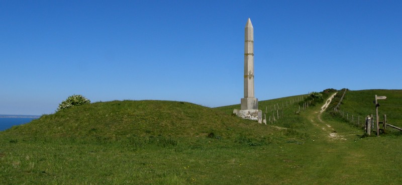
The Ulwell Barrow submitted by JimChampion on 4th Jun 2010. Two-photo panorama of the Ulwell Barrow and the obelisk. The path to the right of the barrow continues up to the highest part of Ballard Down and then onwards along the ridge towards the end of the Purbeck Hills at Ballard Point.
(View photo, vote or add a comment)
Log Text: None
Danby Beacon
Date Added: 19th Sep 2010
Site Type: Round Barrow(s)
Country: England (Yorkshire (North))
Visited: Yes on 30th Jul 2009

Danby Beacon submitted by JimChampion on 30th Jul 2009. The mound on the left is the Bronze Age burial mound re-used in more modern times as Danby Beacon. The beacon sculpture on the barrow was erected the Danby Beacon Trust in 2008, and first lit on the anniversary of Nelson's victory at the Battle of Trafalgar. The top of Beacon Hill, beyond the barrow, was the site of a major Second World War radar station.
(View photo, vote or add a comment)
Log Text: None
Agglestone
Date Added: 19th Sep 2010
Site Type: Natural Stone / Erratic / Other Natural Feature
Country: England (Dorset)
Visited: Yes on 5th Jun 2009
Agglestone submitted by JimChampion on 5th Jun 2009. Approaching the Agglestone along the sandy path from the high ground to the south-west.
(View photo, vote or add a comment)
Log Text: None
Bottlebush Down barrows
Date Added: 19th Sep 2010
Site Type: Barrow Cemetery
Country: England (Dorset)
Visited: Yes on 11th Jan 2009
Bottlebush Down barrows submitted by JimChampion on 11th Jan 2009. Round barrows on Bottlebush Down, viewed from the agger of the Ackling Dyke Roman road, towards Handley Cross.
(View photo, vote or add a comment)
Log Text: None
Alexander Keiller Museum
Date Added: 19th Sep 2010
Site Type: Museum
Country: England (Wiltshire)
Visited: Yes on 31st Dec 2008

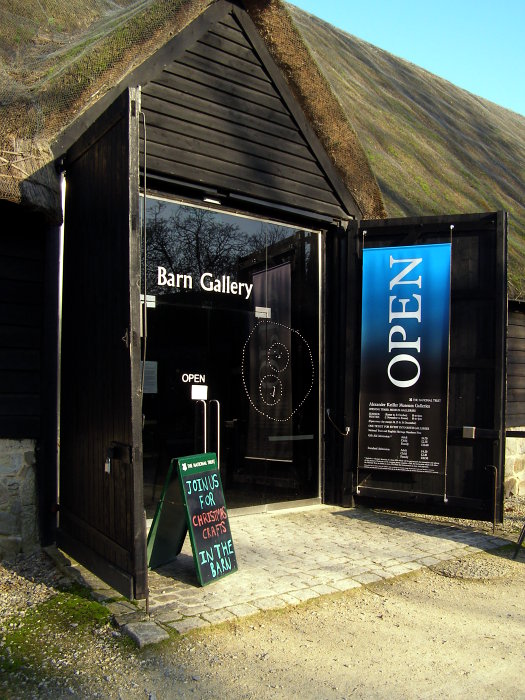
Alexander Keiller Museum submitted by JimChampion on 31st Dec 2008. The door to the Barn Gallery at Avebury. The barn is kept very cool in order to preserve the structure of the 17th century building, so it only houses a few archaeological exhibits - according to the NT leaflet it 'tells the story of the landscape through a fully interactive display'. Most of the archaeology collection is in the nearby Stables Gallery. Both are covered by the same admission ticket, unless you are a member of the National Trust (in which case both galleries are free).
(View photo, vote or add a comment)
Log Text: None
Trevilley Cliff Tumuli
Date Added: 19th Sep 2010
Site Type: Barrow Cemetery
Country: England (Cornwall)
Visited: Yes on 1st Sep 2008
Trevilley Cliff tumuli submitted by JimChampion on 1st Sep 2008. At the top of the slope, the cairn on Trevilley Cliff, at grid reference SW34682417. The path cuts through the left side of the cairn. In the distance on the right are the Land's End buildings (in white).
(View photo, vote or add a comment)
Log Text: None
Boskednan A
Date Added: 19th Sep 2010
Site Type: Cairn
Country: England (Cornwall)
Visited: Yes on 1st Sep 2008
Boskednan A submitted by JimChampion on 1st Sep 2008. Kerb stones, I think, at the cairn at grid reference SW43263530, to the north-west of the Nine Maidens stone circle.
(View photo, vote or add a comment)
Log Text: None
Lescudjack Castle
Date Added: 19th Sep 2010
Site Type: Hillfort
Country: England (Cornwall)
Visited: Yes on 31st Aug 2008
Lescudjack Castle submitted by JimChampion on 31st Aug 2008. From Trengwainton Carn there are splendid views across Mounts Bay. I took this photo, ostensibly of St Michael's Mount, using my camera's maximum zoom from the sunny but windy summit of Trengwainton Carn. Upon closer inspection later on, I found that I had inadvertently photographed Lescudjack Castle in Penzance - it lies roughly half way between The Mount and Trengwainton Carn. In this photo the hillfort is the area lit by direct sunlight in the centre left of the photo. For a version of this p...
(View photo, vote or add a comment)
Log Text: None
Mayon Cliff cairn
Date Added: 19th Sep 2010
Site Type: Cairn
Country: England (Cornwall)
Visited: Yes on 31st Aug 2008
Mayon Cliff cairn submitted by JimChampion on 31st Aug 2008. The cairn on Mayon Cliff, not listed as a scheduled monument by English Heritage. It is in fairly bad condition, but still recognisable on this exposed headland where the elements and visitor pressure keep the vegetation right down. The island in the distance is the Brisons and Cape Cornwall can be seen poking in from the right.
(View photo, vote or add a comment)
Log Text: None
Trengwainton Cross
Date Added: 19th Sep 2010
Site Type: Ancient Cross
Country: England (Cornwall)
Visited: Yes on 31st Aug 2008
Trengwainton Cross submitted by JimChampion on 31st Aug 2008. The front of Trengwainton Cross, after the brambles and bracken had been moved out of the way!
(View photo, vote or add a comment)
Log Text: None
Maen Castle
Date Added: 19th Sep 2010
Site Type: Promontory Fort / Cliff Castle
Country: England (Cornwall)
Visited: Yes on 31st Aug 2008
Maen Castle submitted by JimChampion on 31st Aug 2008. The name "Maen" Castle is from the Cornish for 'stone', and that describes it quite well. This exposed granite headland has many boulders and outcrops, and the promontory fort has little room for occupation. It is thought to be associated with field systems on the slope immediately to the east.
The headland in the distance is Dr Syntax's Head at Land's End, with the Longships rocks and lighthouse offshore.
(View photo, vote or add a comment)
Log Text: None
Boskednan Menhir 2
Date Added: 19th Sep 2010
Site Type: Standing Stone (Menhir)
Country: England (Cornwall)
Visited: Yes on 31st Aug 2008
Boskednan Menhir 2 submitted by JimChampion on 31st Aug 2008. This triangular stone stands on the tumulus at grid reference SW43263530, to the north-west of the Nine Maidens stone circle. The ruin on the hill in the distance is the Greenburrow engine house at the Ding Dong mine.
(View photo, vote or add a comment)
Log Text: None
St Levan's Stone
Date Added: 19th Sep 2010
Site Type: Natural Stone / Erratic / Other Natural Feature
Country: England (Cornwall)
Visited: Yes on 30th Aug 2008
St Levan's Stone submitted by JimChampion on 30th Aug 2008. Not wide enough for a packhorse with panniers astride, so the world's not done just yet. Demonstration by the other Dr Champion.
(View photo, vote or add a comment)
Log Text: None
Creeg Tol
Date Added: 19th Sep 2010
Site Type: Rock Outcrop
Country: England (Cornwall)
Visited: Yes on 29th Aug 2008

Creeg Tol submitted by JimChampion on 29th Aug 2008. View south-west from Creeg Tol, with the rock outcrop and basin(?) in the foreground. The dip in the horizon to the left is at Lamorna, the tower on the horizon to the right is St Buryan. The Boscawen-Un stone circle is a short distance to the south-east, just off to the left of this photo. This is a composite image from two photographs.
(View photo, vote or add a comment)
Log Text: None
St Levan's Well
Date Added: 19th Sep 2010
Site Type: Holy Well or Sacred Spring
Country: England (Cornwall)
Visited: Yes on 29th Aug 2008
St Levan's Well submitted by JimChampion on 29th Aug 2008. The back of St Levan's Well, in its spectacular setting above Porthchapel cove.
(View photo, vote or add a comment)
Log Text: None
Trewern menhir
Date Added: 19th Sep 2010
Site Type: Standing Stone (Menhir)
Country: England (Cornwall)
Visited: Yes on 29th Aug 2008
Trewern menhir submitted by JimChampion on 29th Aug 2008. The Trewern standing stone is just below centre in this photograph. Apologies for the quality, but it was taken at full zoom from a very windy Trengwainton Carn.
(View photo, vote or add a comment)
Log Text: None
Trewern Round
Date Added: 19th Sep 2010
Site Type: Ancient Village or Settlement
Country: England (Cornwall)
Visited: Yes on 29th Aug 2008
Trewern Round submitted by JimChampion on 29th Aug 2008. An oval Iron Age enclosure, about 50 metres in diameter. The stone wall still survives under the hedge, and the whole thing is quite obvious from some distance away. Apologies for the quality of this picture, it was taken from some distance at full zoom, and it was very windy (no tripod!).
(View photo, vote or add a comment)
Log Text: None
