


<< Our Photo Pages >> Carn Galver 2 - Natural Stone / Erratic / Other Natural Feature in England in Cornwall
Submitted by DavidShepherd on Wednesday, 25 March 2020 Page Views: 691
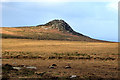
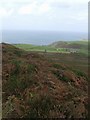
Natural PlacesSite Name: Carn Galver 2Country: England County: Cornwall Type: Natural Stone / Erratic / Other Natural Feature
Nearest Town: St Ives Nearest Village: Rosemergy
Map Ref: SW4279235973
Latitude: 50.167848N Longitude: 5.603148W
Condition:
| 5 | Perfect |
| 4 | Almost Perfect |
| 3 | Reasonable but with some damage |
| 2 | Ruined but still recognisable as an ancient site |
| 1 | Pretty much destroyed, possibly visible as crop marks |
| 0 | No data. |
| -1 | Completely destroyed |
| 5 | Superb |
| 4 | Good |
| 3 | Ordinary |
| 2 | Not Good |
| 1 | Awful |
| 0 | No data. |
| 5 | Can be driven to, probably with disabled access |
| 4 | Short walk on a footpath |
| 3 | Requiring a bit more of a walk |
| 2 | A long walk |
| 1 | In the middle of nowhere, a nightmare to find |
| 0 | No data. |
| 5 | co-ordinates taken by GPS or official recorded co-ordinates |
| 4 | co-ordinates scaled from a detailed map |
| 3 | co-ordinates scaled from a bad map |
| 2 | co-ordinates of the nearest village |
| 1 | co-ordinates of the nearest town |
| 0 | no data |
Internal Links:
External Links:
")
One prop and two points-of-contact.
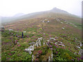
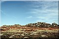
At the immediate foot of the clitter from the tor, this feature ‘faced’ west, perhaps toward the White Downs settlement area. Points-of-contact were not directly with bedrock but with rocks on the bedrock, or possibly a degraded surface layer.
You may be viewing yesterday's version of this page. To see the most up to date information please register for a free account.
Do not use the above information on other web sites or publications without permission of the contributor.
Nearby Images from Geograph Britain and Ireland:
©2006(licence)
©2005(licence)
©2008(licence)
©2008(licence)
©2008(licence)
The above images may not be of the site on this page, they are loaded from Geograph.
Please Submit an Image of this site or go out and take one for us!
Click here to see more info for this site
Nearby sites
Key: Red: member's photo, Blue: 3rd party photo, Yellow: other image, Green: no photo - please go there and take one, Grey: site destroyed
Download sites to:
KML (Google Earth)
GPX (GPS waypoints)
CSV (Garmin/Navman)
CSV (Excel)
To unlock full downloads you need to sign up as a Contributory Member. Otherwise downloads are limited to 50 sites.
Turn off the page maps and other distractions
Nearby sites listing. In the following links * = Image available
67m WNW 291° Carn Galver* Ancient Village or Settlement (SW42733600)
124m WSW 242° Carn Galver* Round Barrow(s) (SW42683592)
216m NNW 330° Carn Galver 1* Natural Stone / Erratic / Other Natural Feature (SW4269236165)
348m SE 145° Bosigran Barrows* Barrow Cemetery (SW42983568)
375m W 276° White downs hut circle and pound* Ancient Village or Settlement (SW42423603)
500m E 81° Little Galver Propped Stone* Natural Stone / Erratic / Other Natural Feature (SW43293603)
590m SSE 160° Four Parishes Rock* Sculptured Stone (SW42973541)
680m S 186° Men Scryfa* Early Christian Sculptured Stone (SW42693530)
688m ENE 59° Hannibal's carn* Ancient Village or Settlement (SW434363)
706m E 87° Carn Galver Cairn* Cairn (SW43503597)
742m WSW 246° Watch Croft Standing Stone* Standing Stone (Menhir) (SW421357)
749m ESE 113° Little Galver Kerbcairns* Ring Cairn (SW43473565)
780m S 169° Venton Bebibell* Holy Well or Sacred Spring (SW429352)
797m NNW 339° Bosigran Kerb Cairn* Cairn (SW42543673)
816m SE 142° Boskednan A* Cairn (SW43273531)
832m SE 142° Boskednan Menhir 2* Standing Stone (Menhir) (SW43273529)
870m SE 142° Boskednan B* Cairn (SW4329435260)
895m S 185° Men-an-tol Mound Cairn (SW4266835086)
929m S 183° Men-an-tol Artificial Mound (SW4270135048)
930m WSW 250° Watch Croft Cairns* Cairn (SW419357)
952m NE 51° Bosporthennis Quoit* Burial Chamber or Dolmen (SW43563654)
977m E 83° Bosporthennis Beehive Hut* Souterrain (Fogou, Earth House) (SW43773604)
993m SE 141° Boskednan Menhir 1* Standing Stone (Menhir) (SW43383517)
995m E 86° Bosporthennis 2* Ancient Village or Settlement (SW43793599)
1.0km S 185° Men-An-Tol* Holed Stone (SW4264434942)
View more nearby sites and additional images


 We would like to know more about this location. Please feel free to add a brief description and any relevant information in your own language.
 Wir möchten mehr über diese Stätte erfahren. Bitte zögern Sie nicht, eine kurze Beschreibung und relevante Informationen in Deutsch hinzuzufügen.
 Nous aimerions en savoir encore un peu sur les lieux. S'il vous plaît n'hesitez pas à ajouter une courte description et tous les renseignements pertinents dans votre propre langue.
 Quisieramos informarnos un poco más de las lugares. No dude en añadir una breve descripción y otros datos relevantes en su propio idioma.