

<< Our Photo Pages >> Carn Galver Cairn - Cairn in England in Cornwall
Submitted by coldrum on Tuesday, 13 October 2009 Page Views: 3465
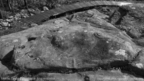
Neolithic and Bronze AgeSite Name: Carn Galver CairnCountry: England County: Cornwall Type: Cairn
Map Ref: SW43503597
Latitude: 50.168128N Longitude: 5.593253W
Condition:
| 5 | Perfect |
| 4 | Almost Perfect |
| 3 | Reasonable but with some damage |
| 2 | Ruined but still recognisable as an ancient site |
| 1 | Pretty much destroyed, possibly visible as crop marks |
| 0 | No data. |
| -1 | Completely destroyed |
| 5 | Superb |
| 4 | Good |
| 3 | Ordinary |
| 2 | Not Good |
| 1 | Awful |
| 0 | No data. |
| 5 | Can be driven to, probably with disabled access |
| 4 | Short walk on a footpath |
| 3 | Requiring a bit more of a walk |
| 2 | A long walk |
| 1 | In the middle of nowhere, a nightmare to find |
| 0 | No data. |
| 5 | co-ordinates taken by GPS or official recorded co-ordinates |
| 4 | co-ordinates scaled from a detailed map |
| 3 | co-ordinates scaled from a bad map |
| 2 | co-ordinates of the nearest village |
| 1 | co-ordinates of the nearest town |
| 0 | no data |
Be the first person to rate this site - see the 'Contribute!' box in the right hand menu.
Internal Links:
External Links:
I have visited· I would like to visit
LiveAndrew visited on 27th Jan 2022 - their rating: Cond: 2 Amb: 4 Access: 3
")
From Pastscape:
"Remains of a cairn near Carn Galver excavated circa 1840 and found to contain a burial urn."
http://www.pastscape.org.uk/hob.aspx?hob_id=423626
You may be viewing yesterday's version of this page. To see the most up to date information please register for a free account.
")
")
")
")
")
")
")
Do not use the above information on other web sites or publications without permission of the contributor.
Click here to see more info for this site
Nearby sites
Key: Red: member's photo, Blue: 3rd party photo, Yellow: other image, Green: no photo - please go there and take one, Grey: site destroyed
Download sites to:
KML (Google Earth)
GPX (GPS waypoints)
CSV (Garmin/Navman)
CSV (Excel)
To unlock full downloads you need to sign up as a Contributory Member. Otherwise downloads are limited to 50 sites.
Turn off the page maps and other distractions
Nearby sites listing. In the following links * = Image available
218m WNW 283° Little Galver Propped Stone* Natural Stone / Erratic / Other Natural Feature (SW43293603)
278m ENE 73° Bosporthennis Beehive Hut* Souterrain (Fogou, Earth House) (SW43773604)
290m E 83° Bosporthennis 2* Ancient Village or Settlement (SW43793599)
321m S 183° Little Galver Kerbcairns* Ring Cairn (SW43473565)
344m NNW 340° Hannibal's carn* Ancient Village or Settlement (SW434363)
573m N 3° Bosporthennis Quoit* Burial Chamber or Dolmen (SW43563654)
589m NE 49° Bosporthennis Well* Holy Well or Sacred Spring (SW4396436335)
594m WSW 238° Bosigran Barrows* Barrow Cemetery (SW42983568)
698m SSW 196° Boskednan A* Cairn (SW43273531)
706m W 267° Carn Galver 2* Natural Stone / Erratic / Other Natural Feature (SW4279235973)
717m SSW 196° Boskednan Menhir 2* Standing Stone (Menhir) (SW43273529)
739m SSW 193° Boskednan B* Cairn (SW4329435260)
768m W 269° Carn Galver* Ancient Village or Settlement (SW42733600)
770m SW 221° Four Parishes Rock* Sculptured Stone (SW42973541)
774m SSE 166° Boskednan 2* Cairn (SW43653521)
778m E 89° Treen Settlement* Ancient Village or Settlement (SW44283595)
808m S 186° Boskednan Menhir 1* Standing Stone (Menhir) (SW43383517)
819m W 264° Carn Galver* Round Barrow(s) (SW42683592)
828m W 281° Carn Galver 1* Natural Stone / Erratic / Other Natural Feature (SW4269236165)
843m S 183° Boskednan stone circle* Stone Circle (SW43423513)
975m SW 215° Venton Bebibell* Holy Well or Sacred Spring (SW429352)
979m SSE 149° Gulval 2 Round Barrow(s) (SW43973511)
1.0km S 177° Boskednan 4* Cairn (SW43503495)
1.0km SW 228° Men Scryfa* Early Christian Sculptured Stone (SW42693530)
1.1km N 352° Porthmeor Fogou* Souterrain (Fogou, Earth House) (SW43413703)
View more nearby sites and additional images


 We would like to know more about this location. Please feel free to add a brief description and any relevant information in your own language.
 Wir möchten mehr über diese Stätte erfahren. Bitte zögern Sie nicht, eine kurze Beschreibung und relevante Informationen in Deutsch hinzuzufügen.
 Nous aimerions en savoir encore un peu sur les lieux. S'il vous plaît n'hesitez pas à ajouter une courte description et tous les renseignements pertinents dans votre propre langue.
 Quisieramos informarnos un poco más de las lugares. No dude en añadir una breve descripción y otros datos relevantes en su propio idioma.