 with our Megalithic Portal iPhone app")

<< Our Photo Pages >> Chantry Well (Brigham) - Holy Well or Sacred Spring in England in Cumbria
Submitted by Anne T on Wednesday, 25 October 2017 Page Views: 2089
Springs and Holy WellsSite Name: Chantry Well (Brigham)Country: England County: Cumbria Type: Holy Well or Sacred Spring
Nearest Town: Cockermouth Nearest Village: Brigham
Map Ref: NY08463083
Latitude: 54.664207N Longitude: 3.420713W
Condition:
| 5 | Perfect |
| 4 | Almost Perfect |
| 3 | Reasonable but with some damage |
| 2 | Ruined but still recognisable as an ancient site |
| 1 | Pretty much destroyed, possibly visible as crop marks |
| 0 | No data. |
| -1 | Completely destroyed |
| 5 | Superb |
| 4 | Good |
| 3 | Ordinary |
| 2 | Not Good |
| 1 | Awful |
| 0 | No data. |
| 5 | Can be driven to, probably with disabled access |
| 4 | Short walk on a footpath |
| 3 | Requiring a bit more of a walk |
| 2 | A long walk |
| 1 | In the middle of nowhere, a nightmare to find |
| 0 | No data. |
| 5 | co-ordinates taken by GPS or official recorded co-ordinates |
| 4 | co-ordinates scaled from a detailed map |
| 3 | co-ordinates scaled from a bad map |
| 2 | co-ordinates of the nearest village |
| 1 | co-ordinates of the nearest town |
| 0 | no data |
Internal Links:
External Links:
I have visited· I would like to visit
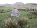
Anne T visited on 14th Aug 2018 - their rating: Cond: -1 Amb: 2 Chantry Well, Brigham (Destroyed) The Reverend Mary told us there was a holy well at Brigham. There are actually 2 listed – Chantry Well and Nun’s Well, next to the A66.
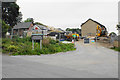
Mr. Furness, the church warden also mentioned the well, but said it was no longer there. In the field opposite the church, a new water pipeline is being constructed. In the field to the south a new housing estate is also being built. There is no access into the field because of the building works, but the grid reference gives a point where the tree line bends.
 (PID:184996)")
Listed in the Old Cumbria Gazetteer and recorded as Pastscape Monument No. 9025, this holy well, the Chantry Well, was destroyed by quarrying, but its location is still recorded.
A new mains water pipeline is being driven through the field in which this well stands, and a housing estate is being constructed (August 2018) in the field immediately to its south.
The well was remembered by local people as being one of two, the other being Nun's Well at NY 0872 3104, sited at the side of the A66, north of Old Parsonage Farm. It is also recorded as having been destroyed, although remnants of it may still be found in the bank that runs parallel to the road.
Due to the building works, no access was allowed into the field, but the red arrow marks the approximate site of this well.
[Update July 2022: This well is recorded as Cumbria Historic Environment Record 847, which tells us: "No traces remain of Chantry Well, which was destroyed by quarrying. A reference in (?) Whellan (1860, p296) notes: 'a rich pasture field near the church, known by the name of Chantry, contains a fine spring, and a mound supposed by some to cover the ruins of some ancient religious edifice'.
Using the grid reference given above, the location of the well is marked on the HE map search, with the site being marked as an ancient site with religious significance.
The well is also briefly recorded in the Old Cumbria Gazetteer - see their entry for Chantry Well.]
Note: Does anyone have any old photographs, drawings or illustrations of this now destroyed holy well?
You may be viewing yesterday's version of this page. To see the most up to date information please register for a free account.
Do not use the above information on other web sites or publications without permission of the contributor.
Nearby Images from Geograph Britain and Ireland:

©2019(licence)
©2019(licence)
©2007(licence)
©2009(licence)
©2019(licence)
The above images may not be of the site on this page, they are loaded from Geograph.
Please Submit an Image of this site or go out and take one for us!
Click here to see more info for this site
Nearby sites
Key: Red: member's photo, Blue: 3rd party photo, Yellow: other image, Green: no photo - please go there and take one, Grey: site destroyed
Download sites to:
KML (Google Earth)
GPX (GPS waypoints)
CSV (Garmin/Navman)
CSV (Excel)
To unlock full downloads you need to sign up as a Contributory Member. Otherwise downloads are limited to 50 sites.
Turn off the page maps and other distractions
Nearby sites listing. In the following links * = Image available
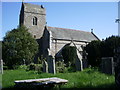
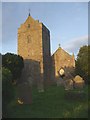
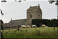
150m NE 52° St Bridget's Church (Brigham)* Ancient Cross (NY0858030920)
334m NE 50° Nun's Well (Brigham) Holy Well or Sacred Spring (NY0872031040)
4.3km NE 47° St Bridget's Church (Bridekirk)* Ancient Cross (NY1164133689)
5.6km SSW 193° St Oswald's Church (Dean)* Rock Art (NY0709725353)
5.7km NNW 347° St Mungo's Dearham* Ancient Cross (NY0724636396)
6.7km ESE 122° Stanger Spa* Holy Well or Sacred Spring (NY14122716)
7.5km ENE 57° Covered Well (Blindcrake)* Holy Well or Sacred Spring (NY14863482)
7.8km NW 323° Maryport Roman Fortress* Ancient Village or Settlement (NY03873721)
8.0km NNE 23° The Hatching Well (Gilcrux)* Holy Well or Sacred Spring (NY1172638137)
8.0km NNE 23° St Mary's Church (Gilcrux)* Ancient Cross (NY1173438176)
8.1km ENE 71° St Michael and All Angels (Isel)* Ancient Cross (NY1624133312)
8.3km NNE 25° Gilcrux Holy Well Holy Well or Sacred Spring (NY1210038270)
8.3km NNW 348° St John The Evangelist (Crosscanonby)* Ancient Cross (NY0691939004)
9.3km E 83° Elvaplain* Stone Circle (NY1770131716)
9.6km SSW 207° Studfold Stone Circle* Stone Circle (NY03992234)
9.6km N 350° Swarthy Hill Multivallate Hillfort Promontory Fort / Cliff Castle (NY0692940323)
11.6km E 89° Castle How Fort Hillfort (NY201308)
12.6km NNE 28° St Patrick's Well (Aspatria)* Holy Well or Sacred Spring (NY147418)
12.7km NNE 28° St Kentigern (Aspatria)* Ancient Cross (NY1475541910)
13.1km ENE 57° The Battery Enclosure* Misc. Earthwork (NY19653775)
13.3km S 187° Lamplugh Stone Circle (NY065177)
14.2km NE 40° Blennerhasset Cross* Ancient Cross (NY1783141517)
16.0km SW 215° Le Wheles Stone Circle (NX989180)
16.1km ENE 67° High Ireby Standing Stone* Standing Stone (Menhir) (NY234369)
16.3km ENE 57° Ireby Old Church* Ancient Cross (NY2238839305)
View more nearby sites and additional images


 We would like to know more about this location. Please feel free to add a brief description and any relevant information in your own language.
 Wir möchten mehr über diese Stätte erfahren. Bitte zögern Sie nicht, eine kurze Beschreibung und relevante Informationen in Deutsch hinzuzufügen.
 Nous aimerions en savoir encore un peu sur les lieux. S'il vous plaît n'hesitez pas à ajouter une courte description et tous les renseignements pertinents dans votre propre langue.
 Quisieramos informarnos un poco más de las lugares. No dude en añadir una breve descripción y otros datos relevantes en su propio idioma.