Featured: Lost Secrets - an adventure during Neolithic times

Lost Secrets - an adventure during Neolithic times

Random Image


Balix Lower

Solving Stonehenge, the new key to an ancient enigma

Solving Stonehenge, the new key to an ancient enigma

Who's Online

There are currently, 271 guests and 2 members online.

You are a guest. To join in, please register for free by clicking here

Sponsors

<< Our Photo Pages >> Giants Leap Wedge Tomb - Wedge Tomb in Ireland (Republic of) in Co. Cavan

Submitted by Anthony_Weir on Wednesday, 25 October 2017  Page Views:

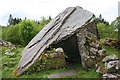
Neolithic and Bronze AgeSite Name: Giants Leap Wedge Tomb Alternative Name: Cavan Burren, The Giant's Grave, Legalough
Country: Ireland (Republic of) County: Co. Cavan Type: Wedge Tomb
Nearest Town: Sligo  Nearest Village: Blacklion
Map Ref: H0787435232
Discovery Map Number: D26
Latitude: 54.265891N  Longitude: 7.879903W
Condition:
5Perfect
4Almost Perfect
3Reasonable but with some damage
2Ruined but still recognisable as an ancient site
1Pretty much destroyed, possibly visible as crop marks
0No data.
-1Completely destroyed
4 Ambience:
5Superb
4Good
3Ordinary
2Not Good
1Awful
0No data.
5 Access:
5Can be driven to, probably with disabled access
4Short walk on a footpath
3Requiring a bit more of a walk
2A long walk
1In the middle of nowhere, a nightmare to find
0No data.
3 Accuracy:
5co-ordinates taken by GPS or official recorded co-ordinates
4co-ordinates scaled from a detailed map
3co-ordinates scaled from a bad map
2co-ordinates of the nearest village
1co-ordinates of the nearest town
0no data
5

Internal Links:
External Links:

I have visited· I would like to visit

macd visited on 1st Aug 2014 - their rating: Cond: 5 Amb: 5 Access: 4 Incredible area, but you really need a guided tour to understand what is going on, or at least download Gaby and Jim's amazing book - .pdf link on this website. The area is littered with modified boulders, field systems, hut sites etc in a wild and beautiful location, so get your walking boots on, take a picnic and explore. There's a small visitor centre and parking but no toilets, cafe or anything. Don't let that put you off - it's an enchanting area with so much to see and a credit to the local people (Gaby & Jim in particular) who noticed and recorded features hitherto unrecognised by the archaeological community. It pays to keep your eyes - and minds - open!

Giants Leap Wedge Tomb
Giants Leap Wedge Tomb submitted by Anthony_Weir : Photo by Anthony Weir (Vote or comment on this photo)
Wedge Tomb in Co. Cavan. Approached from a track running S from Tullygobban Lough into dreary conifer plantation, this tomb is a fine, large and well-preserved example with a gallery over 7 metres long, divided by a high septal slab into a long portico and a large main chamber.

NOTE: ‘Burren’ comes from the Irish for a stony place, and is a not-uncommon place-name. This tomb is not in THE Burren of county Clare, where there are dozens of typical Irish wedge-tombs.

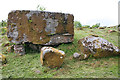
The gallery is covered by 5 roofstones, 3 of which cover the main chamber, and one of which has chock-stones. The front capstone has a series of depressions which may be artificial cup-marks. Two of the front orthostats of the façade lean together to form a triangular entrance to the antechamber. The septal slab has a gap at the bottom of the N end which seems artificial. The tomb resembles some of the large gallery-tombs (allées-couvertes) of France, and is well worth the trouble of searching for.

It can also be approached from the county Fermanagh side, via a lane leading SW from the ‘Marlbank Scenic Loop’ to the forest fence.

The stones visible on the skyline to the S of the wedge-tomb are the remains of the forecourt of a court-tomb in Legalough. Beyond this again is another wedge-tomb, more typically Irish than that of Burren.

~ 2.4 km ENE, in county Fermanagh is Clyhannagh single-court tomb whose gallery is distinctly kinked – suggesting that a two-chambered megalithic kist was enlarged by the addition of two more chambers and a forecourt.

~ 5.6 km NNW, also in county Fermanagh, on the other side of Lough Macnean Upper, 500 metres N of the Belcoo-Garrison road (H 062401) is Kilrooskagh portal-tomb, which must have been spectacular before its 3 x 2.4 metre capstone collapsed. Only three other stones survive.

Note: Burren-Marlbank - A Prehistoric Monumental Landscape by Gaby Burns and Jim Nolan - an important new ebook which sheds light on a little known aspect of megalithic architecture and its association with nearby rock art and boulder monuments. Details and free download in the comments on our page and more to come soon as we look to add more of these enigmatic sites to the Megalithic Portal.
You may be viewing yesterday's version of this page. To see the most up to date information please register for a free account.


Giants Leap Wedge Tomb
Giants Leap Wedge Tomb submitted by michmax : Detail of the Giant's Grave Wedge tomb in the beautiful surroundings of the Cavan Burren (Vote or comment on this photo)

Do not use the above information on other web sites or publications without permission of the contributor.

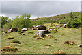
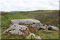
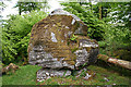
Nearby Images from Geograph Britain and Ireland:
H0735 : Erratics and Stumps by Anne Burgess
by Anne Burgess
©2014(licence)
H0735 : Boulder Tomb by Anne Burgess
by Anne Burgess
©2014(licence)
H0735 : Boulder Tomb by Anne Burgess
by Anne Burgess
©2014(licence)
H0735 : Pedestal Erratic by Anne Burgess
by Anne Burgess
©2014(licence)
H0735 : Portal Tomb by Anne Burgess
by Anne Burgess
©2014(licence)

The above images may not be of the site on this page, they are loaded from Geograph.
Please Submit an Image of this site or go out and take one for us!


Click here to see more info for this site

Nearby sites

Click here to view sites on an interactive map of the area

Key: Red: member's photo, Blue: 3rd party photo, Yellow: other image, Green: no photo - please go there and take one, Grey: site destroyed

Download sites to:
KML (Google Earth)
GPX (GPS waypoints)
CSV (Garmin/Navman)
CSV (Excel)

To unlock full downloads you need to sign up as a Contributory Member. Otherwise downloads are limited to 50 sites.


Turn off the page maps and other distractions

Nearby sites listing. In the following links * = Image available
 439m W 274° Tullygobban Wedge Tomb* Wedge Tomb (H0743435259)
 582m W 262° Boulder Grave* Chambered Tomb
 583m W 262° Calf house Portal Tomb* Portal Tomb (H0729535148)
 779m SW 224° Boulder Monument PB48* Natural Stone / Erratic / Other Natural Feature (H0733234670)
 788m SW 225° Boulder Monument PB46* Natural Stone / Erratic / Other Natural Feature (H0731934670)
 1.7km SE 132° The Dumbies Court Tomb (H09123413)
 2.3km SW 236° Moneygashel* Stone Fort or Dun (H0594933908)
 3.2km NW 323° St Brigid' Stones Stone Row / Alignment (H059378)
 3.2km NW 323° Killinagh* Rock Art (H059378)
 3.3km ESE 112° Tromogagh Stone Circle (H110340)
 4.8km N 2° Cloghbrack Stone Circle (H080400)
 5.0km NNW 340° Kilrooskagh Portal Tomb (H06143998)
 6.5km NNW 343° Toppan Stone Circle (H060415)
 6.7km NNW 343° Cloghastuckane Stone Circle (H059416)
 8.3km NW 324° Corraderrybrock Stone Circle (H030420)
 8.4km NNE 12° Aghanaglack Court Tomb (H096435)
 9.6km ESE 110° Aghatirourke Stone Circle (H1692831965)
 10.0km NNE 27° Reyfad Stones Stone Row / Alignment (H124442)
 11.1km E 91° Greenan Stone Circle (H190350)
 11.1km NW 313° Corracloona* Court Tomb (G997428)
 13.2km NNE 29° Ross Lough Crannog (H14294677)
 15.1km N 359° Rossinure More Court Tomb (H07715039)
 15.3km N 357° Rossinure Beg Court Tomb (H06915053)
 16.0km NW 317° Kilcoo Stone Circle (G970470)
 16.1km N 357° Doagh Glebe Promontory Fort / Cliff Castle (H0709051350)
View more nearby sites and additional images

<< Chantry Well (Brigham)

St Cuthbert's Church (Darlington) >>

Please add your thoughts on this site

Clickable Map of Ireland

Bending the Boyne: a Novel of Ancient Ireland

Bending the Boyne: a Novel of Ancient Ireland

Sponsors

Auto-Translation (Google)

Translate from English into:

"Giants Leap Wedge Tomb" | Login/Create an Account | 9 News and Comments
  
Go back to top of page    Comments are owned by the poster. We aren't responsible for their content.
Re: Burren by Andy B on Sunday, 06 May 2018
(User Info | Send a Message)
Class Megalithic tomb - wedge tomb
Townland BURREN (Tullyhaw By., Tuam ED)
SMR No. CV004-005----
Description Situated on a hilltop and is surrounded by trees. It is well preserved and consists of a roofed gallery, about 7.5m long, opening to the WSW. A tallseptal-stone divides it into a long portico and main chamber. An outer wall surrounds the gallery. Two slabs 0.6m apart, form the entrance to the portico which is 2.4m long and 1.1m wide. It is covered by two roofstones: the upper surface of the outer-most W stone has a series of cup-marks and at least two cup-and-ring motifs (CV004-005001-). A stone standing in the portico is of uncertain function. The main chamber, 4.5m long, narrows from 1.3m wide at the septal-stone to 1m at the E. A set stone continues the line of the N side of the gallery beyond the backstone. Three horizontally laid slabs roof the main chamber. Five outer wall stones remain in place. Some are now leaning and the westernmost at the N is broken in two. (de Valera and Ó Nualláin 1972, 106-8, No. 5) The above description is derived from the published 'Archaeological Inventory of County Cavan' (Dublin: Stationery Office, 1995). In certain instances the entries have been revised and updated in the light of recent research. Revised by: Paul Walsh Date of revision: 10 May 2012 See linked document with details from Ruaidhrí de Valera and Seán Ó Nualláin, Survey of the Megalithic Tombs of Ireland. Volume III. Counties Galway, Roscommon, Leitrim, Longford, Westmeath, Laoighis, Offaly, Kildare, Cavan. (Dublin: Stationery Office, 1972).

Source: NMS Ireland

More:
https://maps.environ.ie/arcgis/rest/services/NM/NationalMonuments/MapServer/0/29454/attachments/1225
[ Reply to This ]

Burren Street View by Runemage on Saturday, 05 May 2018
(User Info | Send a Message)

[ Reply to This ]

Burren-Marlbank - A Prehistoric Monumental Landscape by Gaby Burns and Jim Nolan by Andy B on Wednesday, 25 October 2017
(User Info | Send a Message)
An important new ebook which sheds light on a little known aspect of megalithic architecture and its association with nearby rock art and boulder monuments:

Burren-Marlbank A Prehistoric Monumental Landscape by Gaby Burns and Jim Nolan

A few miles from the border between County Cavan and County Fermanagh (and hence also the Irish Republic and Northern Ireland - which is part of the UK) lies the enigmatic bulk of Cuilcagh Mountain. This is an important part of the landscape of the Marble Arch Caves UNESCO Global Geopark which itself straddles the Irish border

Extract from Gaby Burns' introduction: This book is unusual, so also are the monuments and carvings. Jim and I have been exploring this area, as a team, since 1997 and individually for a long time before that. Together we have journeyed through the living spaces of past generations and have come to recognise how they expressed themselves through the stones - we don’t understand these messages but they must have been very important ones. What we do know is that we are privileged to be the first people in many thousands of years to uncover these special monuments and carvings.

Originally when we had our initial rock art findings published in Archaeology Ireland in 2007 we were greatly encouraged and at that stage we started to prepare a paper for submission to The Journal of Irish Archaeology. We abandoned this as we realised that at that stage it would have meant reducing all our discoveries to a summary and representative examples only - we realised that nothing less than publication of the ALL the discoveries would do, which is how this book came to be.

We we have taken the unusual step of providing our conclusions in the first chapter, to help the reader. Although we call them conclusions they really are just a summary of what we have found. After all we are presenting a number of completely new discoveries - even the ‘names’ of these features will be unfamiliar to readers as we had to invent a lot of new terminology. At least from the start you are warned what to expect!

We are both proud to say that the survey is a ‘local’ production as opposed to a ‘professional’ one by researchers that only too often disappear after - with their results only available to their own ‘closed’ group of ‘readers’. We can claim that we have already been sharing the discoveries over the years with the local community through numerous ‘guided walks’. Too many archaeological surveys are never seen by local people.

One original concern, which remains, is that the 30km of relict walls and nearly 200 hut/house site would be ‘sidelined’ by the ‘more spectacular’ boulder monuments and rock art - this has already happened. Yet we feel that these are at least equivalent to the Céide fields and what’s more, unlike the Céide fields, they are all on the surface, intact. We desperately need an excavation by archaeologists to help date these.

The Burren-Marlbank survey was started in 1997, covering one parish in County Cavan and another parish in County Fermanagh. The survey work was carried out exclusively by two researchers - Gaby Burns & Jim Nolan (aka Séamus Ó hUltacháin). All the recording and mapping was undertaken by Gaby Burns.

Atlantic Rock Art is very well studied as a subject and is to be found widespread in what is described as the Atlantic fringe countries. Yet to date rock art is rarely to be found in context with any other archaeological features apart from megalithic rock art on passage tombs and a few other isolated situations.

The Burren-Marlbank is unique as there is not only an abundance of rock art in a small area but it is probably the only rock art in the Atlantic fringe which is to be found within an integrated landscape of settlement features and associated boulder monuments. This is the very thing that rock art specialists have found to be missing elsewhere. There is more...

In addition to the rock art there is a

Read the rest of this post...
[ Reply to This ]
    Re: Burren-Marlbank - A Prehistoric Monumental Landscape by Gaby Burns and Jim Nolan by macd on Sunday, 05 November 2017
    (User Info | Send a Message)
    I met Gaby Burns 4 years ago at the Bronze Age Forum and was instantly fascinated by his investigations in the Cavan Burren-Marlbank area. I've had the privilege of a guided tour with him and bought the hardcopy book of the downloadable .pdf. It's so refreshing to have someone open-minded enough to make such discoveries, so I urge everyone to download the .pdf - or buy the book if you're in the area, but above all, come and look for yourselves.
    [ Reply to This ]

About Boulder PB140 (see page 86 of the book for further details) by Andy B on Wednesday, 25 October 2017
(User Info | Send a Message)
PB140 is a fairly ‘insignificant’ boulder but it has become an evidence ‘clincher’ as it confirms a number of major features. First it has typical sculptings such as deep circular hollow, channels and ridges. Magda Kluj, geologist, (pers. comm.), pointed out that they are clearly cut across bedding planes, as with PB45 (page 81 of book), hence the geology clearly shows they are anthropogenic (ie man made) - it is an Evidence Boulder based upon this geological evidence. The channels and ridges are directly comparable with PB47 (page 83 of book) and thereby geologically validates it also.

Secondly there are three ridges that are demonstrably directional ). Firstly there is a clear line of sight along one of the PB140 ridges on PB47 (page 8) and an even more interesting line of sight along another ridge on Giant’s Leap Tomb. What makes this
really interesting is that it is also on exactly the same alignment as the tomb itself, 243°/63° Even more significant is that this alignment is on the sunset on two cross quarter days. The tomb is clearly facing/aligned on the sunset on Imbolg and Samhain. This also means that the ridge on PB140 is directional on both a monument and an astronomical event.

See page 86 of the book (linked above) for further details
Burren-Marlbank - A Prehistoric Monumental Landscape by Gaby Burns and Jim Nolan
[ Reply to This ]

The wedge tomb at the Giant's Leap by Andy B on Wednesday, 25 October 2017
(User Info | Send a Message)
Séamus Ó hUltacháin writes: The wedge tomb at the Giant's Leap is perhaps the finest of its kind in Ireland. In addition to these recognized tombs there are a number of modified glacial erratics which may well be "prototype" graves. One of these, now classified as a tomb has a chamber carved from the limestone pedestal underneath.

Recently discovered cup and ring marks under a thin layer of peat on the overlying glacial erratic plus two adjacent "framing" pillar stones and further evidence of rock art nearby has confirmed it as a grave. This whole complex faces north-east, into the rising sun on the summer solstice. The Giants Leap wedge tomb and Tullygobban Hill wedge tomb (see nearby sites list) both face south-west, into the setting sun on the winter solstice.

Immediately outside the forest in the townland of Legolough and adjacent to each other are a court tomb, a wedge tomb and a round cairn. The Legolough tombs command magnificent views of surrounding lake and mountain, as did the Burren tombs prior to afforestation and when the forest was young. These views are commented on by Ruaidhri de Valera and SeanÓ Nualláin in their Survey of the Megalithic Tombs of Ireland.

That such a variety of tombs exist in Burren and surrounding townlands would suggest settlement in this area over a prolonged period in prehistory. Portal tombs are now generally dated to the period 3500 B.C. – 4000 B.C; court tombs to circa 3000 B.C; while wedge tombs were built in the Final Neolithic / early Bronze Age. An unusual feature of one of the portal tombs in Burren is that it survives in an almost intact round cairn. (This is the tomb Wakeman called a "perfect Newgrange in miniature" - see ref on web page ). Another larger dolmen (the "Calf House") was converted into an animal shelter in the late nineteenth century but is still hugely impressive – not least for its beautifully sculpted transverse portal stones.

Thirty seven hut sites have been discovered in the Burren Forest while a total of approximately one hundred and fifty hut or house sites have been discovered during the course of our wider survey in the Burren – Marlbank area. The huts usually survive as single small circular or oval footings of stone. However there is one site consisting of five contiguous rings of stone. We named this the "Taj Mahal". It is located approximately fifty metres from a large circular enclosure, also containing hut sites, which may well be the original clearing in the prehistoric forest. Beside this multiple hut complex is a probable prototype tomb with a "causeway" running back from it to the circular enclosure.

Read more at
http://cavanburren.ie/index.php?option=com_content&view=category&layout=blog&id=1&Itemid=2
[ Reply to This ]

Burren area and Prototype Tombs / Modified Glacial Erratics by Andy B on Sunday, 18 June 2017
(User Info | Send a Message)
About three kilometres south of Blacklion and north-west of Cuilcagh Mountain lies a remarkable limestone plateau at an altitude of between seven hundred and nine hundred feet, which is now beginning to be recognized as one of the finest relict landscapes of its size in all of Ireland.

Burren is in every respect a "relict" landscape. Its funereal monuments, habitation sites and fields survive from prehistoric times. Its glacial erratics survive from the last ice age while its dry valley and associated doline bear testimony to a pre-glacial river and sink. The fossils embedded in its limestone are the coral of a tropical sea of 350 million years ago.

The area is a unique educational resource, showing not only the history of human settlement from the tombs of the early Neolithic settlers to the limekilns and animal shelters of the nineteenth century farmers but in addition to this the evolution of a landscape from its formation in a tropical sea south of the Equator, through the various ice ages to the present. It is a palimpsest of history with layer upon layer of both human and natural history visible on its karstic features.

Its geographical location, plus the political situation in Northern Ireland probably contributed to a general lack of knowledge and appreciation of the Burren archaeological sites during the final third of the twentieth century. During this time also the maturing coniferous forest made access to the monuments extremely difficult, hiding from the general public this wonderful repository of human and natural history.

taken from "The Relict Landscape of the Burren Area of North-West Cavan" By Séamus Ó hUltacháin

The Cavan Burren is now part of the Marble Arch Caves Global Geopark, one of numerous UNESCO Global Geoparks found across the world. Some of the forestry has been cleared and pathways and signposts have been provided to many of the archaeological and historical sites.

Recent Discoveries in The Cavan Burren / Marlbank area

Prototype Tombs / Modified Glacial Erratics
"Prototype tombs are in fact modified glacial erratics which have been used for funereal purposes. They have not been found anywhere else in Ireland. We have for long suspected that they were tombs but did not get confirmation until quite recently.

They are very special - the missing link between the natural monuments (glacial erratic pedestal rocks) and the built megalithic monuments!!!.

Numerous other modified glacial erratics in the Cavan Burren and surrounding area (some incorporated into relict field walls) are also suggestive of sacred space and may have served as loci for ritual deposition in prehistoric times."

Séamus Ó hUltacháin 2009

More at http://cavanburren.ie

NOTE: ‘Burren’ comes from the Irish for a stony place, and is a not-uncommon place-name. This area is not in THE Burren of county Clare, where there are dozens of Irish wedge-tombs.
[ Reply to This ]
    Re: Burren area and Prototype Tombs / Modified Glacial Erratics by Andy B on Sunday, 18 June 2017
    (User Info | Send a Message)
    See Geograph photos above, including H0735 : Boulder Tomb. One of the archaeological features of the Cavan Burren is the so-called boulder tombs. These are large erratics partly supported by masonry, with burial chambers hollowed out underneath. They are described as the missing link between the natural monuments and the built megalithic monuments.
    [ Reply to This ]

Re: Burren by optimistic20814 on Sunday, 24 July 2016
(User Info | Send a Message)
This tomb is now far easier to access through the area's new Cavan Burren Megalithic Park. Much of the forestry has been hewn, and many sites are along well signed walking paths with information signs. i spent a lovely afternoon there in late June 2016. See entries under Tullyboggan Tomb, etc.
[ Reply to This ]

Your Name: Anonymous [ Register Now ]
Subject:


Add your comment or contribution to this page. Spam or offensive posts are deleted immediately, don't even bother

<<< What is five plus one as a number? (Please type the answer to this question in the little box on the left)
You can also embed videos and other things. For Youtube please copy and paste the 'embed code'.
For Google Street View please include Street View in the text.
Create a web link like this: <a href="https://www.megalithic.co.uk">This is a link</a>  

Allowed HTML is:
<p> <b> <i> <a> <img> <em> <br> <strong> <blockquote> <tt> <li> <ol> <ul> <object> <param> <embed> <iframe>

We would like to know more about this location. Please feel free to add a brief description and any relevant information in your own language.
Wir möchten mehr über diese Stätte erfahren. Bitte zögern Sie nicht, eine kurze Beschreibung und relevante Informationen in Deutsch hinzuzufügen.
Nous aimerions en savoir encore un peu sur les lieux. S'il vous plaît n'hesitez pas à ajouter une courte description et tous les renseignements pertinents dans votre propre langue.
Quisieramos informarnos un poco más de las lugares. No dude en añadir una breve descripción y otros datos relevantes en su propio idioma.