 with our Megalithic Portal iPhone app")

<< Our Photo Pages >> St Oswald's Church (Dean) - Rock Art in England in Cumbria
Submitted by Anne T on Monday, 29 August 2022 Page Views: 3110
Early Medieval (Dark Age)Site Name: St Oswald's Church (Dean) Alternative Name: Dean Church (Cumbria)Country: England
NOTE: This site is 0.4 km away from the location you searched for.
County: Cumbria Type: Rock Art
Nearest Town: Lilyhall Nearest Village: Dean
Map Ref: NY0709725353
Latitude: 54.614752N Longitude: 3.440096W
Condition:
| 5 | Perfect |
| 4 | Almost Perfect |
| 3 | Reasonable but with some damage |
| 2 | Ruined but still recognisable as an ancient site |
| 1 | Pretty much destroyed, possibly visible as crop marks |
| 0 | No data. |
| -1 | Completely destroyed |
| 5 | Superb |
| 4 | Good |
| 3 | Ordinary |
| 2 | Not Good |
| 1 | Awful |
| 0 | No data. |
| 5 | Can be driven to, probably with disabled access |
| 4 | Short walk on a footpath |
| 3 | Requiring a bit more of a walk |
| 2 | A long walk |
| 1 | In the middle of nowhere, a nightmare to find |
| 0 | No data. |
| 5 | co-ordinates taken by GPS or official recorded co-ordinates |
| 4 | co-ordinates scaled from a detailed map |
| 3 | co-ordinates scaled from a bad map |
| 2 | co-ordinates of the nearest village |
| 1 | co-ordinates of the nearest town |
| 0 | no data |
Internal Links:
External Links:
I have visited· I would like to visit
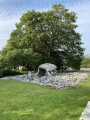
Anne T visited on 24th Jul 2022 - their rating: Cond: 3 Amb: 4 Access: 5 St Oswald's Church (Dean): Having left St Michael and All Angels at Isel, we visited the well in Eaglesfield and tried to find the Singing Well just outside Deanscales. The latter we could see over the hedge, but were unable to gain access to the field it sits in from the road. Parking by the lych gate of the church, walking along the southern side of the church, the preaching cross is easily visible, sitting on what looks like the base of a large market cross, with seven steps. The cross at the top is topped by a 'modern' (18th century) sundial.
We spent some considerable time in the church with the notes provided, tracking and photographing the medieval grave slabs that were visible. Enjoyed this visit.
 (PID:245341)")
The churchyard cross location is NY 07097 25353, and it is Grade II listed. It is recorded separately as Historic England List ID 1326878, which dates the cross "to probably the 17th century", although the notes provided within the church say the steps are original and may date from the 12th century, consistent with the date the church was founded (or even possibly pre-dating it); "the truncated cross shaft is much later".
The church is Grade I listed Historic England List ID 1145164,
This cup and ring marked boulder is featured on The Northern Antiquarian (TNA) - see their page for Dean Church (Cumbria). TNA give directions for finding the church, together with a brief archaeology & history plus a 1992 drawing and image by Stan Beckensall.
Whilst on mentioning only that "further architectural discoveries were made in 1967, the church is described in Pastscape Monument No. 8856, mentioning that it might originally have been a vicar's pele.
There is no official church guide available for sale within the church, but several A4 typed, illustrated pages which give a detailed history of the church and the artefacts within.
You may be viewing yesterday's version of this page. To see the most up to date information please register for a free account.
 (PID:245345)")
 (PID:245290)")
 (PID:245344)")
 (PID:245761)")
 (PID:245760)")
 (PID:245758)")
 (PID:245757)")
 (PID:245756)")
 (PID:245746)")
 (PID:245745)")
 (PID:245343)")
 (PID:245342)")
 (PID:178831)")
 (PID:178830)")
 (PID:178829)")
 (PID:178828)")
Do not use the above information on other web sites or publications without permission of the contributor.
Click here to see more info for this site
Nearby sites
Key: Red: member's photo, Blue: 3rd party photo, Yellow: other image, Green: no photo - please go there and take one, Grey: site destroyed
Download sites to:
KML (Google Earth)
GPX (GPS waypoints)
CSV (Garmin/Navman)
CSV (Excel)
To unlock full downloads you need to sign up as a Contributory Member. Otherwise downloads are limited to 50 sites.
Turn off the page maps and other distractions
Nearby sites listing. In the following links * = Image available
4.3km SW 225° Studfold Stone Circle* Stone Circle (NY03992234)
5.6km NNE 13° Chantry Well (Brigham)* Holy Well or Sacred Spring (NY08463083)
5.8km NNE 14° St Bridget's Church (Brigham)* Ancient Cross (NY0858030920)
5.9km NNE 15° Nun's Well (Brigham) Holy Well or Sacred Spring (NY0872031040)
7.2km ENE 74° Stanger Spa* Holy Well or Sacred Spring (NY14122716)
7.7km S 183° Lamplugh Stone Circle (NY065177)
9.5km NNE 27° St Bridget's Church (Bridekirk)* Ancient Cross (NY1164133689)
11.0km SW 227° Le Wheles Stone Circle (NX989180)
11.0km N 360° St Mungo's Dearham* Ancient Cross (NY0724636396)
11.4km S 184° Blakeley Raise* Stone Circle (NY06011403)
12.1km NE 48° St Michael and All Angels (Isel)* Ancient Cross (NY1624133312)
12.2km NE 38° Covered Well (Blindcrake)* Holy Well or Sacred Spring (NY14863482)
12.3km NNW 344° Maryport Roman Fortress* Ancient Village or Settlement (NY03873721)
12.3km ENE 58° Elvaplain* Stone Circle (NY1770131716)
13.6km NNE 19° The Hatching Well (Gilcrux)* Holy Well or Sacred Spring (NY1172638137)
13.6km NNE 19° St Mary's Church (Gilcrux)* Ancient Cross (NY1173438176)
13.6km N 358° St John The Evangelist (Crosscanonby)* Ancient Cross (NY0691939004)
13.7km S 182° Swarth Fell funerary cairn* Round Cairn (NY06241167)
13.8km NNE 20° Gilcrux Holy Well Holy Well or Sacred Spring (NY1210038270)
14.1km ENE 66° Castle How Fort Hillfort (NY201308)
14.6km S 178° Capelcrag Beck* Ring Cairn (NY07231072)
15.0km N 358° Swarthy Hill Multivallate Hillfort Promontory Fort / Cliff Castle (NY0692940323)
15.0km S 190° Yewcroft* Stone Circle (NY043106)
15.3km S 184° Friar's Well Barrow Cemetery (NY058101)
15.5km SW 217° St Bega's Well (St Bees) Holy Well or Sacred Spring (NX9751413094)
View more nearby sites and additional images


 We would like to know more about this location. Please feel free to add a brief description and any relevant information in your own language.
 Wir möchten mehr über diese Stätte erfahren. Bitte zögern Sie nicht, eine kurze Beschreibung und relevante Informationen in Deutsch hinzuzufügen.
 Nous aimerions en savoir encore un peu sur les lieux. S'il vous plaît n'hesitez pas à ajouter une courte description et tous les renseignements pertinents dans votre propre langue.
 Quisieramos informarnos un poco más de las lugares. No dude en añadir una breve descripción y otros datos relevantes en su propio idioma.